Extended Description of the Vector Map
Printable PDF Vector Map of Delhi India Metro Area Attractions High Detailed street map fully editable Layered Adobe PDF scalable, text/curves format all names, 119 MB ZIP
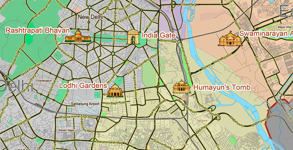
Principal street names, Attractions Historical Objects, City Districts. Map for design, printing, arts, projects, presentations, for architects, designers, and builders, business, logistics.
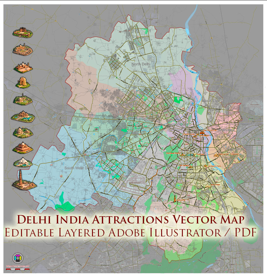
Delhi India Metro Area PDF Map Vector Attractions Exact High Detailed Street Map editable Adobe PDF in layers
Layers list:
- Legend
- Names of places (city, hamlet, etc.)
- Names of Attraction objects (parks, hospital, water)
- Names of main streets
- ATTRACTIONS ICONS POINTS 1,2,3 – PNG and Vectors
- Main Streets, roads
- Residential streets
- Railroads
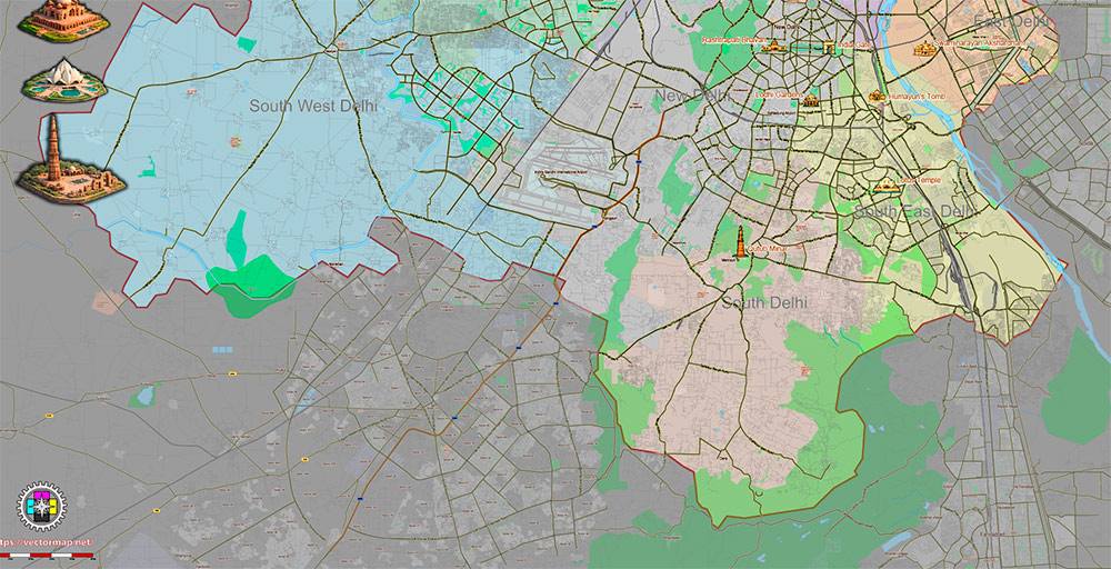
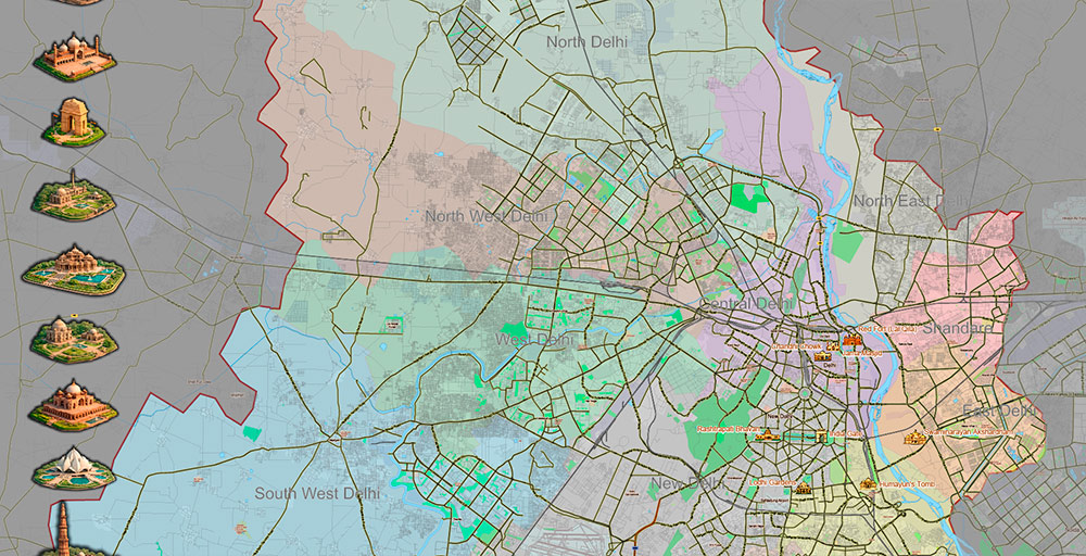
- City Districts with names
- Water objects (rivers, lakes, ponds)
- Waterways
- Color fills (parks, land use, etc.)
- Islands
- Background 1,2
The most exact and detailed map of the Delhi India Metro Area Attractions in scale.
For Editing and High-Quality Printing
Delhi India Metro Area PDF Map Vector Attractions Exact High Detailed Street Map editable Adobe PDF in layers
AO Brief — Delhi Urban Agglomeration
Overview
The Delhi Urban Agglomeration is one of the largest and most dynamic metropolitan regions in the world, centered on Delhi, the national capital territory of India. It encompasses an extensive urban fabric including New Delhi, Old Delhi, and sprawling suburbs extending into the neighboring states of Haryana and Uttar Pradesh.
Geography
The agglomeration lies in northern India on the fertile alluvial plains of the Yamuna River, a major tributary of the Ganges. The terrain is predominantly flat, with the river forming a central geographic axis. The climate is subtropical, with hot summers, a monsoon season, and cool winters.
Key Cities & Municipal Areas
Road & Transport Network
The road network is extensive and hierarchical, featuring:
-
National Highways linking the city to the rest of India
-
Major arterial roads including Ring Roads, Inner and Outer Ring Roads
-
Radial avenues connecting core districts to suburbs
-
Expressways facilitating high-speed transit (e.g., Yamuna Expressway, Delhi–Gurugram Expressway)
The agglomeration is served by a multimodal transport system:
-
Metro Rail network spanning extensive urban and suburban corridors
-
Bus Rapid Transit and comprehensive city bus services
-
Intercity rail terminals connecting to national rail routes
-
Multiple regional airports with Indira Gandhi International Airport as the primary hub
Demographics
The population of the Delhi Urban Agglomeration is among the highest globally, characterized by:
-
Dense, continuously growing urban density
-
A diverse socio-cultural mix drawn from every region of India
-
A large working-age population with significant youth representation
-
Rapid ongoing migration from rural and peri-urban areas
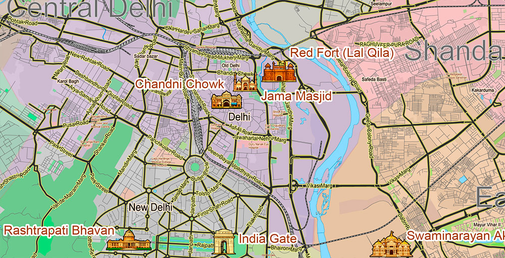
Landmarks & Points of Interest
The region hosts numerous historic, cultural, and political landmarks:
Urban Structure & Zones
The city’s functional layout includes:
-
Central administrative and diplomatic zones
-
Dense commercial and business districts
-
Residential sectors of varied typologies
-
Industrial and technology parks
-
Expansion corridors and satellite township developments
Transport & Mobility
-
Metro is a backbone for daily commuters
-
Road congestion is significant; elevated expressways and ring roads mitigate peak loads
-
Multi-modal hubs integrate rail, metro, bus, and taxi services
-
Non-motorized transport infrastructure is present but under continuous expansion
Socio-Economic Dynamics
-
Major center for services, government administration, IT, finance, and education
-
High economic output relative to regional peers
-
Urban challenges include housing demand, air quality, and infrastructure capacity
Cartographic Features for Vector Map
For an editable urban plan, layers should include:
-
Road hierarchy (national highways, expressways, arterial and local streets)
-
Administrative boundaries (city sectors, districts, suburbs)
-
Transit infrastructure (metro lines/stations, bus depots, rail lines)
-
Rivers, canals, and major green spaces
-
Landmark and point feature layer (historical and civic)
-
Elevation/terrain context (flat plains, river floodplain)
Intended Use
This vector map is suitable for:
-
Urban planning and GIS analysis
-
Transport modeling and logistics
-
Demographic visualization
-
Presentation and design projects
-
Strategic decision support
Delhi India Metro Area PDF Map Vector Attractions Exact High Detailed Street Map editable Adobe PDF in layers
Delhi India Metro Area PDF Map Vector Attractions Exact High Detailed Street Map editable Adobe PDF in layers

Delhi India Metro Area PDF Map Vector Attractions Exact High Detailed Street Map editable Adobe PDF in layers
Delhi India Metro Area PDF Map Vector Attractions Exact High Detailed Street Map editable Adobe PDF in layers

 Author: Kirill Shrayber, Ph.D. FRGS
