About this vectorial map of Czech Republic (Europe) in (.AI) format
Archive size: 5.8 Mb, zipped .AI
DPI: 300
Vector Map Data: 2016
License: Royalty Free
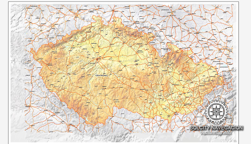
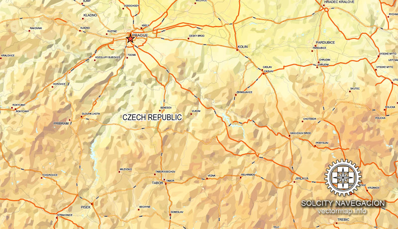
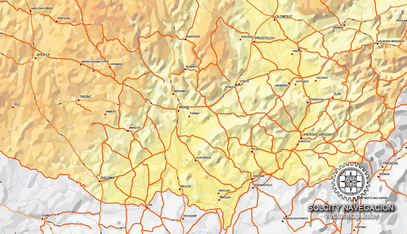
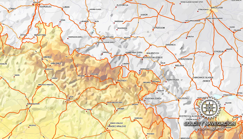
Czech Republic vector Relief road map in Adobe Illustrator [.AI] are full editable maps, which can be printed in all sizes needed, no matter what big it is. With no quality loss, because it`s vector format.
All maps in VectorMap portal has a Royalty Free license. You don`t pay for each use, you can change all the content you want, including line thickness, font design, or add the objects you want.
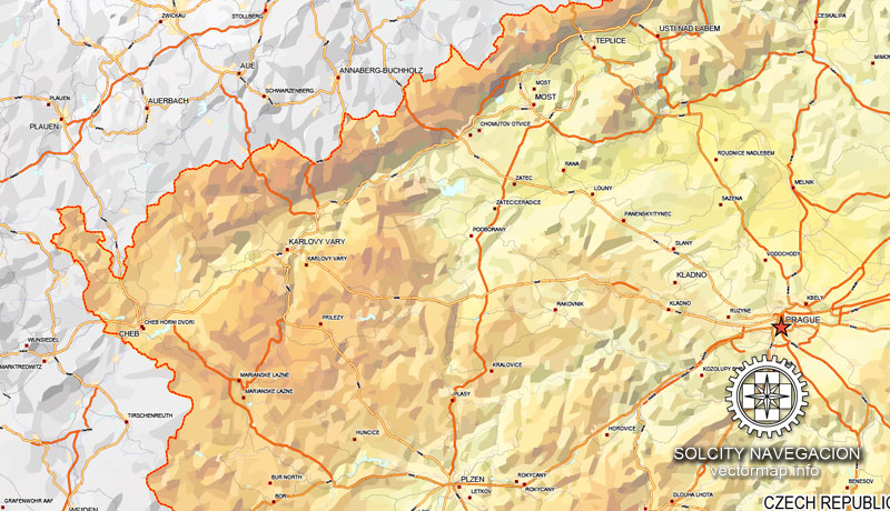
We provide very precise Relief road map of Czech Republic, perfect for large size printing, like office walls or billboards.
Also available in other formats at the same price: DWG, DXF AutoCAD, CDR, EPS, PDF.
This Czech Republic vector map features:
Highways, major roads
Relief road map
Big and small Rivers, small streams also,
Lake, ponds and other water bodies,
Landmark fill.
Need more data, or something special? Please, feel free to contact our friendly team.
Czech Republic.
This vector map of Czech Republic is used as a basis for design, editing, and further printing.
This is the most detailed, exact map of Czech Republic for high-quality printing and polygraphy. You can always clarify the map development date by contacting us.
For your convenience, all objects on Czech Republic vector map are divided into layers. And the editing is very easy – colors, lines, etc.
You can easily add any objects needed (e.g. shops, salons, sale points, gas station or attraction) on any layer of Czech Republic vector map.
The Czech Republic is a landlocked country in Central Europe bordered by Germany to the west, Austria to the south, Slovakia to the east and Poland to the northeast. The Czech Republic covers an area of 78,866 square kilometres (30,450 sq mi) with a mostly temperate continental climate and oceanic climate. It is a unitary parliamentary republic, with 10.6 million inhabitants; its capital and largest city is Prague, with 1.3 million residents. Other major cities are Brno, Ostrava and Pilsen. The Czech Republic is a member of the European Union (EU), NATO, the OECD, the United Nations, the OSCE, and the Council of Europe.
One of the advantages of Czech Republic vector maps of our production is the relevance of cartographic data, we constantly update all our products.
This vector map of Czech Republic is used by:
designers, layout designers, printers, advertisers and architects. Our product – vector maps – is designed for further editing and printing in large formats – from @Wall format (a few meters) to A-0 and A-1, A-2, A-3.
The Czech Republic map in vector format is used for design, urban planning, presentations and media visualizations.
The advertising and presentation map of Czech Republic (usually the final designer marks the routes, and puts the client’s objects (shops, saloons, gas stations etc.)
The undoubted advantage is that people will NEVER throw out this advertising product – the map. In fact, as an advertising medium, a map is the most “long-playing” of the well-known polygraphic advertising media, with the longest lifespan, and the maximum number of interactions with the customer.
For travelers, maps are sold at the airports and gas stations around the world. Often the source is our vector maps.
Take a look, who purchases our vector maps of Czech Republic in “Our Clients and Friends” page – these are large and small companies, from super-brands like Volvo and Starbucks, to small design studios and printing houses.
It’s very easy to work with vector maps of Czech Republic city, even for a not very experienced designer who can turn on and off the map layers, add new objects, change the colors of fill and lines according to customer requirements.
The undoubted advantage of Czech Republic vector maps in printing is an excellent and detailed visualization, when customer can expand a large paper map and instantly define his location, find a landmark, an object or address on map, unlike using the popular electronic formats of Google and Yandex maps for example.
Printable vector maps of Czech Republic are much more convenient and efficient than any electronic maps on your smartphone, because ALL DETAILS are displayed in the entire space of Czech Republic map.
Useful tips on working with vector maps of cities and countries in Adobe Illustrator.
«V» – launches the Selection tool (cursor, black arrow), which makes active any vector line.
«А» – launches the Direct Selection tool (white cursor), allows you to select curve elements and drag them to the desired place.
«R» – activates the Rotate tool, which helps you rotating selected objects around the center point by 360 degrees.
«E» – gives you the opportunity to use the Eraser tool and erase unnecessary parts.
«X» – switches between Fill and Stroke in the Tools section. Try to get used to this hot key and
you will quickly understand that you can’t live and work without it.
Guides are not limited to vertical and horizontal in Adobe Illustrator. You can also create a diagonal guide for example. Moreover, you can turn any contours into guides. Select the outline and go to View > Guides > Make Guides (Create Guides), or simply press Cmd/Ctrl + 5. You can also turn the guides back into an editable object. Go to menu, View > Guides > Unlock Guides (Release Guides), select the guide you want to edit and select View > Guides > Release Guides (Reset Guides), or just press Cmd/Ctrl + Option / Alt + 5).
You will probably want to change the color scheme used on our Czech Republic vector map.
To quickly and effectively play with colors.
Of course, you can do it manually, all objects in our Czech Republic vector map are divided according to types and layers, and you can easily change the color gamma of vector objects in groups and layers.
But there is more effective way of working with the whole VECTOR MAP of Czech Republic and all layers:
The overview dialog «Edit colors»/«Repaint Graphic Object» (this dialog box name can change depending on the context):
If you have selected a part or a layer of Czech Republic vector map and open the dialog box by clicking the icon in the Control panel, on the Samples palette or the Color Catalog, or if you choose Edit > Edit Colors> Repaint Graphic Object, then the «Repaint Graphic Object» dialog box appears, and you get access to «Assign» and «Edit» tabs.
If a picture or a map fragment is not selected, and you open the dialog box by clicking the icon in the Control panel, on the Samples palette or in the Color Catalog, the «Edit Colors» dialog box appears and you can only access the «Edit» tab.
Regardless of the name at the top of the dialog box, the right-hand side always displays the color group of the current document, as well as two default color groups: Print Color and Grayscale. These color groups can be selected and used any time.
Create and edit color groups of Czech Republic vector map, and also assign colors using the «Edit Colors»/ а «Repaint Graphic Object» dialog box.
A. Creating and editing of a color group on the «Edit» tab
B. Assigning colors on the «Assign» tab
C. Select a group of colors from the «Color groups» list
The option «Repaint a graphic object» in the lower part of the dialog box allows you to preview the colors on a selected layer of Vector map, or a group of elements, and specify whether its colors will be redefined when the dialog box is closed.
The main areas of the dialog box are:
«Edit»
The «Edit» tab is designed to create a new or edit the existing color groups.
The harmony rules Menu and the Color Wheel are used to conduct experiments with color harmonies. The color wheel shows how colors are related in color harmony, and the color bars allow you to view and manipulate an individual color values. In addition, you can adjust the brightness, add and remove colors, save color groups and view colors on the selected Vector Map of Czech Republic or a separated layers.
«Assign»
The «Assign» tab is used to view and control on how the original colors are replaced with colors from the color group like your corporate colors in the Vector Map of Czech Republic city.
The assign color ability is provided only if the entire map, layer or fragment is selected in the document. You can specify which of new colors replace the current colors, whether the spot colors should be preserved and how colors are replaced (for example, you can replace colors completely or changing the color tone while maintaining the brightness). The «Assign» tab allows you to redefine colors in the Vector Map of Czech Republic city, or in separate layers and fragments using the current color group or reducing the number of colors in the current Vector Map.
Color groups
Is a list of all saved color groups for current document (the same groups appear in the «Samples» palette). You can edit and delete the existing color groups, as well as creating a new ones using the list of “Color Groups” in the dialog box. All changes appear in the «Samples» palette.
The highlighted color group shows, which color group is currently edited.
Any color group can be selected and edited, or used to redefine the colors in the selected vector map of Czech Republic city, its fragments or elements.
Saving a color group adds this group to the specified list.
Opening the «Edit Colors»/«Repaint Graphic Object» dialog box.
Open the «Edit Colors»/«Repaint Graphic Object» dialog box using one of the following methods:
«Edit»> «Edit Colors»> «Repaint Graphic object» or «Repaint With Style».
Use these commands if you need to edit the colors in the selected vector map of Czech Republic city.
«Repaint Graphic object» button on the «Control» panel.
Use this button if you need to adjust colors of Czech Republic vector map using the а «Repaint graphic object» dialog box.
The specified button is available if the selected vector map or its fragment contains two or more colors.
Note. This color editing method is convenient for global color adjustment in a vector map, if global colors were not used when creating a Map of Czech Republic.
The «Edit colors» button or «Edit or apply colors» on the «Color Catalog» palette
Click this button if you need to edit colors on the «Color Catalog» palette or edit and then apply them to the selected Vector Map of Czech Republic or its fragment.
The «Edit color group» button or «Edit or apply color group» on the «Samples» palette.
Click this button if you need to edit the colors in the specific color group or edit and apply them to the selected Vector Map of Czech Republic or a group of its elements, for example, the whole layer “Streets and lines”. You can also double-click the color group in the Samples panel to open the dialog box.
If the map file is too large and your computer freezes or even can’t open it quickly:
1. Try to reduce the color resolution of the video card (display) to 256 colors while working with a large map.
2. Using Windows Task Manager, select all the application you don’t need, while working with map, just turn them off.
3. Launch Adobe Illustrator. (DO NOT OPEN the vector map file)
4. Start the Windows Task Manager using administrator rights > Find the “Illustrator” process > set the «real time» priority,
5. Open the file. When you see the LEGACY FONT popup window – click “OK” (do not update). You can restore the TEXT later.
6. Can also be useful: When file is opened – Edit > Settings > Basic Settings > disable smoothing. /// It looks scary, but works quickly)))
We recommend saving the file in Adobe Illustrator 10 version. It’s much more stable when working with VERY BIG size files.
It is a developed country with an advanced, high income export-oriented social market economy based in services, manufacturing and innovation. The UNDP ranks the country 14th in inequality-adjusted human development. The Czech Republic is a welfare state with a “continental” European social model, a universal health care system, tuition-free university education and is ranked 14th in the Human Capital Index. It ranks as the 6th safest or most peaceful country and is one of the most non-religious countries in the world, while achieving strong performance in democratic governance.
The Czech Republic includes the historical territories of Bohemia, Moravia, and Czech Silesia. The Czech state was formed in the late 9th century as the Duchy of Bohemia under the Great Moravian Empire. After the fall of the Empire in 907, the centre of power transferred from Moravia to Bohemia under the Přemyslid dynasty. In 1002, the duchy was formally recognized as part of the Holy Roman Empire, becoming the Kingdom of Bohemia in 1198 and reaching its greatest territorial extent in the 14th century. Besides Bohemia itself, the king of Bohemia ruled the lands of the Bohemian Crown, he had a vote in the election of the Holy Roman Emperor, and Prague was the imperial seat in periods between the 14th and 17th century. In the Hussite Wars of the 15th century driven by the Protestant Bohemian Reformation, the kingdom faced economic embargoes and defeated five consecutive crusades proclaimed by the leaders of the Catholic Church.
Following the Battle of Mohács in 1526, the whole Crown of Bohemia was gradually integrated into the Habsburg Monarchy alongside the Archduchy of Austria and the Kingdom of Hungary. The Protestant Bohemian Revolt (1618–20) against the Catholic Habsburgs led to the Thirty Years’ War. After the Battle of the White Mountain, the Habsburgs consolidated their rule, eradicated Protestantism and reimposed Catholicism, and also adopted a policy of gradual Germanization. This contributed to the anti-Habsburg sentiment. A long history of resentment of the Catholic Church followed and still continues. With the dissolution of the Holy Roman Empire in 1806, the Bohemian Kingdom became part of the Austrian Empire and the Czech language experienced a revival as a consequence of widespread romantic nationalism. In the 19th century, the Czech lands became the industrial powerhouse of the monarchy and were subsequently the core of the Republic of Czechoslovakia, which was formed in 1918 following the collapse of the Austro-Hungarian Empire after World War I.
Czechoslovakia remained the only democracy in this part of Europe in the interwar period. However, the Czech part of Czechoslovakia was occupied by Germany in World War II, while the Slovak region became the Slovak Republic; Czechoslovakia was liberated in 1945 by the armies of the Soviet Union and the United States. The Czech country lost the majority of its German-speaking inhabitants after they were expelled following the war. The Communist Party of Czechoslovakia won the 1946 elections and after the 1948 coup d’état, Czechoslovakia became a one-party communist state under Soviet influence. In 1968, increasing dissatisfaction with the regime culminated in a reform movement known as the Prague Spring, which ended in a Soviet-led invasion. Czechoslovakia remained occupied until the 1989 Velvet Revolution, when the communist regime collapsed and market economy was reintroduced. On 1 January 1993, Czechoslovakia peacefully dissolved, with its constituent states becoming the independent states of the Czech Republic and Slovakia. The Czech Republic joined NATO in 1999 and the EU in 2004.
Geography
The Czech Republic lies mostly between latitudes 48° and 51° N (a small area lies north of 51°), and longitudes 12° and 19° E.
The Czech landscape is exceedingly varied. Bohemia, to the west, consists of a basin drained by the Elbe and the Vltava rivers, surrounded by mostly low mountains, such as the Krkonoše range of the Sudetes. The highest point in the country, Sněžka at 1,603 m (5,259 ft), is located here. Moravia, the eastern part of the country, is also quite hilly. It is drained mainly by the Morava River, but it also contains the source of the Oder River (Czech: Odra).
Water from the landlocked Czech Republic flows to three different seas: the North Sea, Baltic Sea and Black Sea. The Czech Republic also leases the Moldauhafen, a 30,000-square-metre (7.4-acre) lot in the middle of the Hamburg Docks, which was awarded to Czechoslovakia by Article 363 of the Treaty of Versailles, to allow the landlocked country a place where goods transported down river could be transferred to seagoing ships. The territory reverts to Germany in 2028.
Phytogeographically, the Czech Republic belongs to the Central European province of the Circumboreal Region, within the Boreal Kingdom. According to the World Wide Fund for Nature, the territory of the Czech Republic can be subdivided into four ecoregions: the Western European broadleaf forests, Central European mixed forests, Pannonian mixed forests, and Carpathian montane conifer forests.
There are four national parks in the Czech Republic. The oldest is Krkonoše National Park (Biosphere Reserve), and the others are Šumava National Park (Biosphere Reserve), Podyjí National Park, Bohemian Switzerland.
The three historical lands of the Czech Republic (formerly the core countries of the Bohemian Crown) correspond almost perfectly with the river basins of the Elbe (Czech: Labe) and the Vltava basin for Bohemia, the Morava one for Moravia, and the Oder river basin for Czech Silesia (in terms of the Czech territory).
Cities and counties near or inside Czech Republic vectorial map, Europe
Looking for more Czech Republic vector maps?
Purchasing and downloading of Adobe Illustrator Czech Republic (Europe) vectorial Relief road map
We accept PayPal and Credit Card payment. After the payment you will be redirected to the download page. We guarantee 100% satisfaction. Royalty Free license.

 Author: Kirill Shrayber, Ph.D. FRGS


