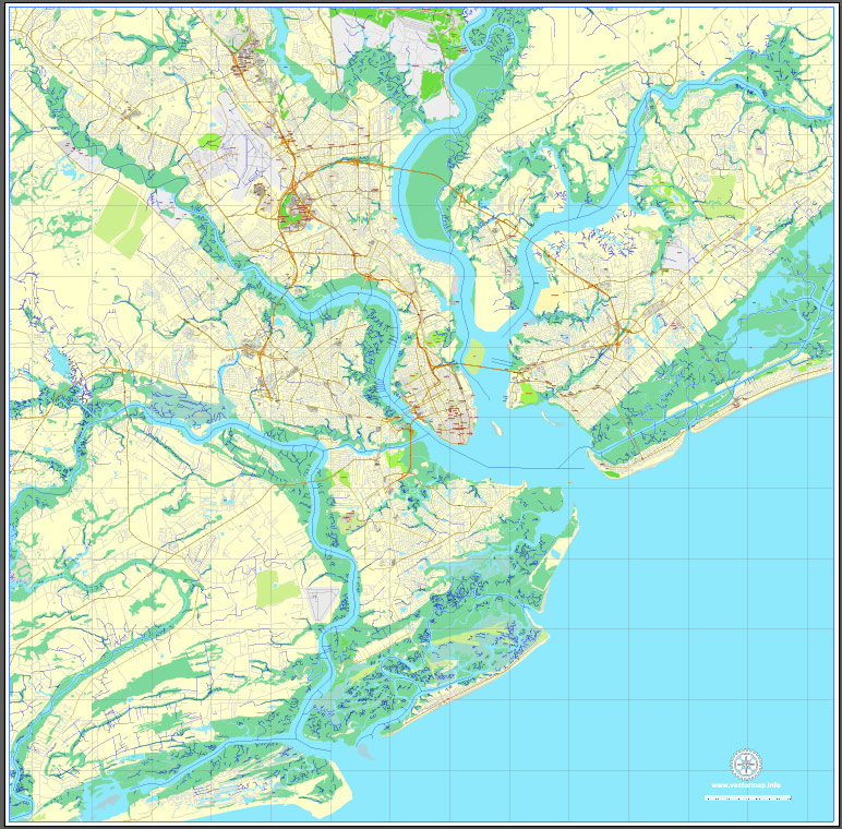
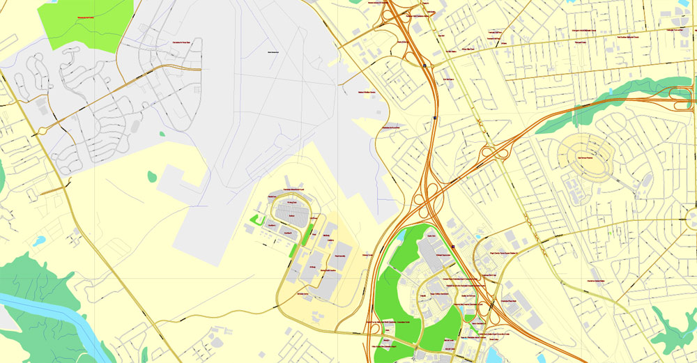
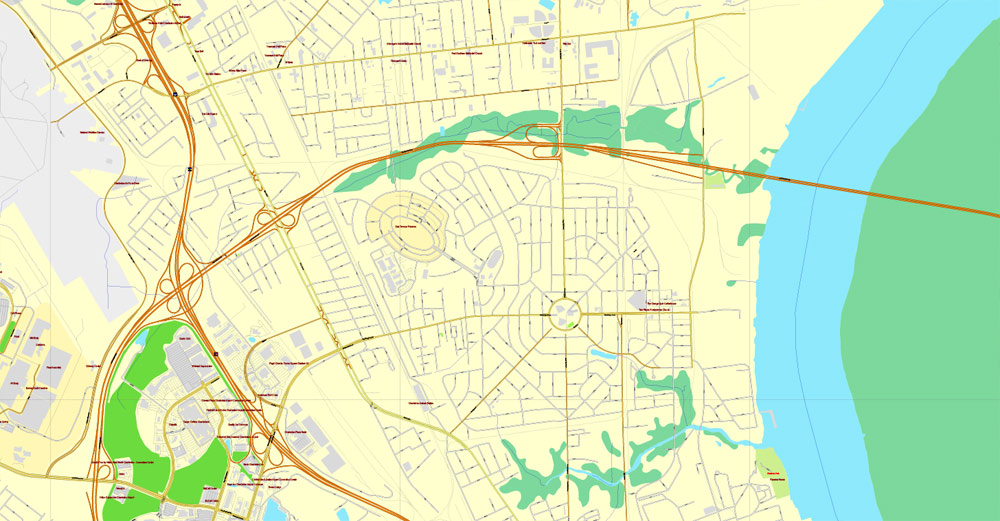
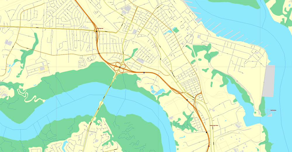
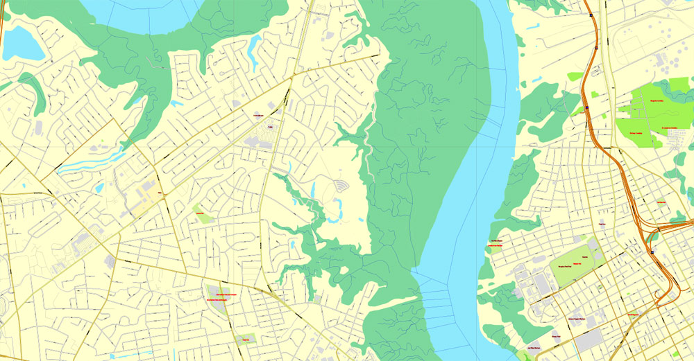
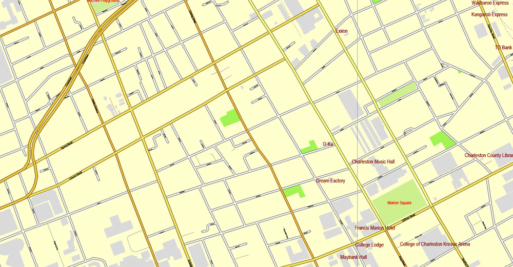
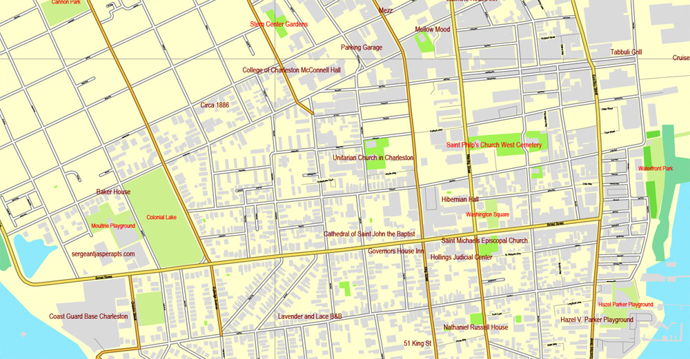
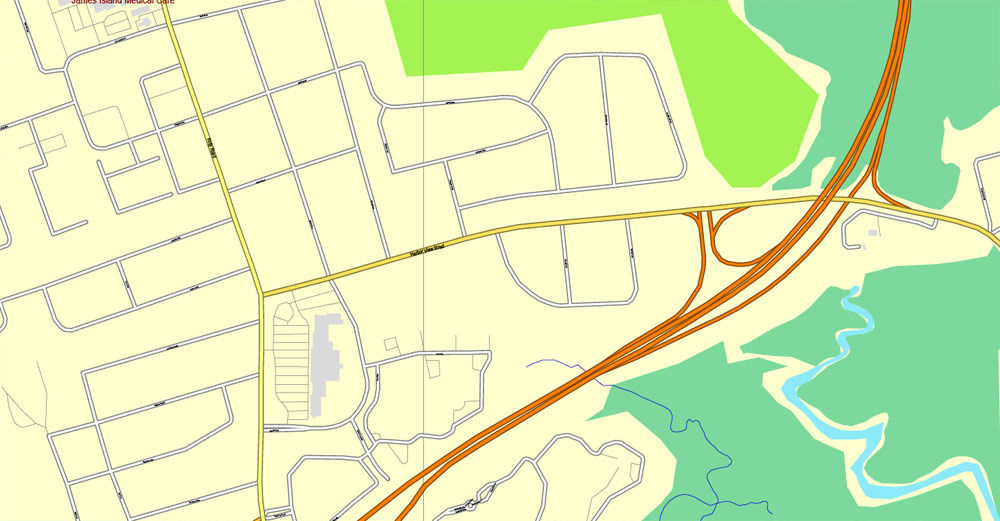
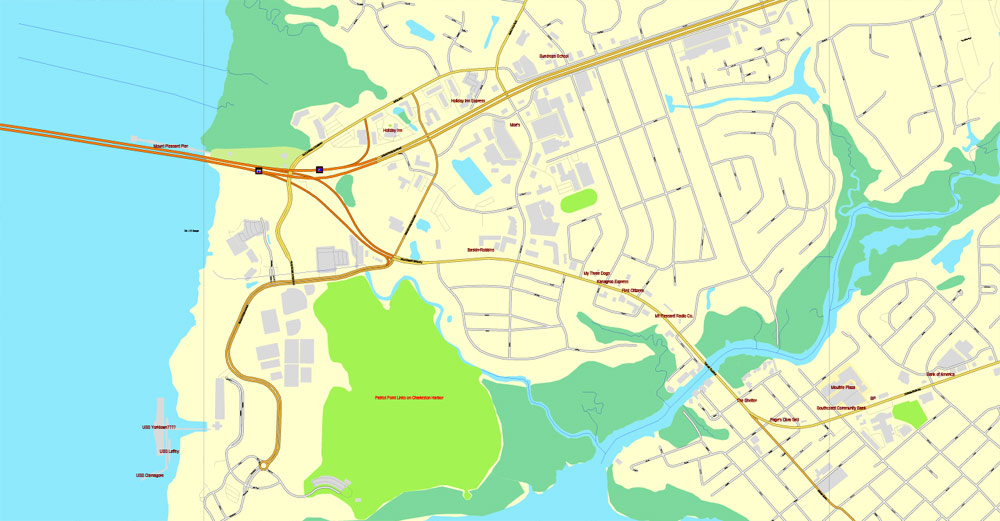
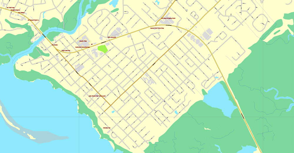
Charleston, South Carolina, PDF Map, US, exact vector street City Plan map, fully editable, Adobe PDF, V3.10 Center, full vector, scalable, editable, text format street names, 17 Mb ZIP.
All streets, primary buildings. Map for design, print, arts, projects, presentations.
PDF, DXF, CDR and other formats – on request, same price, please, contact.
You can edit this file by Adobe Illustrator, Adobe Acrobat, Corel Draw.
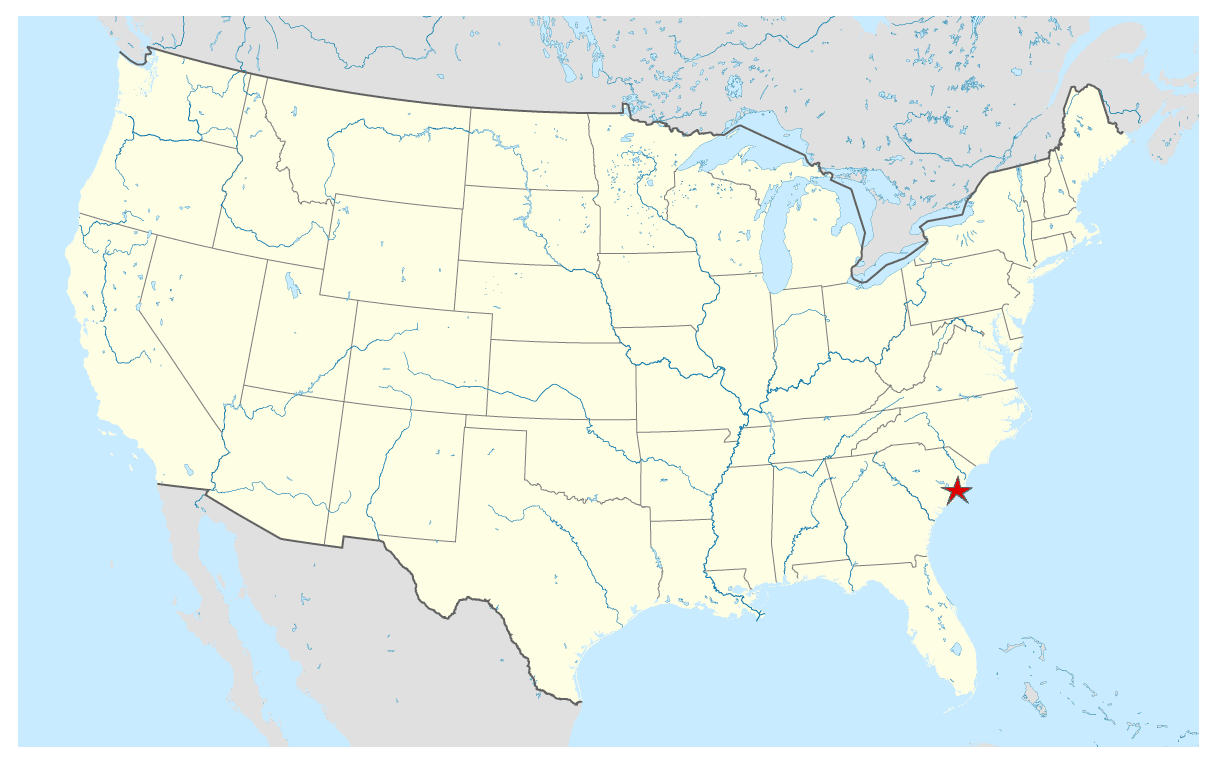
Charleston, South Carolina, USA.
This vector map of Charleston city is used as a basis for design, editing, and further printing.
This is the most detailed, exact map of Charleston city for high-quality printing and polygraphy. You can always clarify the map development date by contacting us.
You can easily add any objects needed (e.g. shops, salons, sale points, gas station or attraction) on any layer of Charleston vector map.
Charleston is the oldest and largest city in the U.S. state of South Carolina, the county seat of Charleston County, and the principal city in the Charleston–North Charleston–Summerville Metropolitan Statistical Area.
This vector map of Charleston city is used by:
designers, layout designers, printers, advertisers and architects. Our product – vector maps – is designed for further editing and printing in large formats – from @Wall format (a few meters) to A-0 and A-1, A-2, A-3.
The city lies just south of the geographical midpoint of South Carolina’s coastline and is located on Charleston Harbor, an inlet of the Atlantic Ocean formed by the confluence of the Ashley, Cooper, and Wando rivers.
The Charleston city map in vector format is used for design, urban planning, presentations and media visualizations.
The advertising and presentation map of Charleston city (usually the final designer marks the routes, and puts the client’s objects (shops, saloons, gas stations etc.)
The undoubted advantage is that people will NEVER throw out this advertising product – the map. In fact, as an advertising medium, a city map is the most “long-playing” of the well-known polygraphic advertising media, with the longest lifespan, and the maximum number of interactions with the customer.
Charleston had an estimated population of 134,875 in 2017. The estimated population of the Charleston metropolitan area, comprising Berkeley, Charleston, and Dorchester counties, was 761,155 residents in 2016, the third-largest in the state and the 78th-largest metropolitan statistical area in the United States.
For travelers, maps are sold at the airports and gas stations around the world. Often the source is our vector maps.
Take a look, who purchases our vector maps of Charleston city in “Our Clients and Friends” page – these are large and small companies, from super-brands like Volvo and Starbucks, to small design studios and printing houses.
Charleston was founded in 1670 as Charles Town, honoring King Charles II of England. Its initial location at Albemarle Point on the west bank of the Ashley River (now Charles Towne Landing) was abandoned in 1680 for its present site, which became the fifth-largest city in North America within ten years.
Printable vector maps of Charleston city are much more convenient and efficient than any electronic maps on your smartphone, because ALL DETAILS are displayed in the entire space of Charleston city map.
Useful tips on working with vector maps of cities and countries in Adobe Illustrator.
«V» – launches the Selection tool (cursor, black arrow), which makes active any vector line.
«А» – launches the Direct Selection tool (white cursor), allows you to select curve elements and drag them to the desired place.
«R» – activates the Rotate tool, which helps you rotating selected objects around the center point by 360 degrees.
«E» – gives you the opportunity to use the Eraser tool and erase unnecessary parts.
«X» – switches between Fill and Stroke in the Tools section. Try to get used to this hot key and
you will quickly understand that you can’t live and work without it.
Population growth in the interior of South Carolina influenced the removal of the state government to Columbia in 1788, but the port city remained among the ten largest cities in the United States through the 1840 census. Historians estimate that “nearly half of all Africans brought to America arrived in Charleston”, most at Gadsden’s Wharf.
Guides are not limited to vertical and horizontal in Adobe Illustrator. You can also create a diagonal guide for example. Moreover, you can turn any contours into guides. Select the outline and go to View > Guides > Make Guides (Create Guides), or simply press Cmd/Ctrl + 5. You can also turn the guides back into an editable object. Go to menu, View > Guides > Unlock Guides (Release Guides), select the guide you want to edit and select View > Guides > Release Guides (Reset Guides), or just press Cmd/Ctrl + Option / Alt + 5).
The only major antebellum American city to have a majority-enslaved population, Charleston was controlled by an oligarchy of white planters and merchants who successfully forced the federal government to revise its 1828 and 1832 tariffs during the Nullification Crisis and launched the Civil War in 1861 by seizing the Arsenal, Castle Pinckney, and Fort Sumter from their federal garrisons.
You will probably want to change the color scheme used on our Charleston vector city map.
To quickly and effectively play with colors.
Of course, you can do it manually, all objects in our Charleston city vector map are divided according to types and layers, and you can easily change the color gamma of vector objects in groups and layers.
Known for its rich history, well-preserved architecture, distinguished restaurants, and hospitable people, Charleston is a popular tourist destination. It has received numerous accolades, including “America’s Most Friendly” by Travel + Leisure in 2011 and in 2013 and 2014 by Condé Nast Traveler, and also “the most polite and hospitable city in America” by Southern Living magazine. In 2016, Charleston was ranked the “World’s Best City” by Travel + Leisure.
But there is more effective way of working with the whole VECTOR MAP of Charleston city and all layers:
The overview dialog «Edit colors»/«Repaint Graphic Object» (this dialog box name can change depending on the context):
If you have selected a part or a layer of Charleston city vector map and open the dialog box by clicking the icon in the Control panel, on the Samples palette or the Color Catalog, or if you choose Edit > Edit Colors> Repaint Graphic Object, then the «Repaint Graphic Object» dialog box appears, and you get access to «Assign» and «Edit» tabs.
If a picture or a map fragment is not selected, and you open the dialog box by clicking the icon in the Control panel, on the Samples palette or in the Color Catalog, the «Edit Colors» dialog box appears and you can only access the «Edit» tab.
Regardless of the name at the top of the dialog box, the right-hand side always displays the color group of the current document, as well as two default color groups: Print Color and Grayscale. These color groups can be selected and used any time.
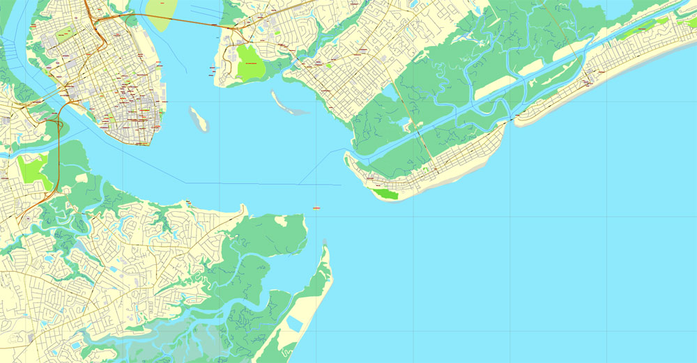
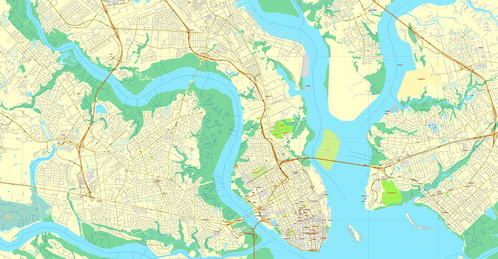
Downtown, or sometimes referred to as The Peninsula, is Charleston’s center city separated by the Ashley River to the west and the Cooper River to the east.
West Ashley, residential area to the west of Downtown bordered by the Ashley River to the east and the Stono River to the west.
Create and edit color groups of Charleston city vector map, and also assign colors using the «Edit Colors»/ а «Repaint Graphic Object» dialog box.
A. Creating and editing of a color group on the «Edit» tab
B. Assigning colors on the «Assign» tab
C. Select a group of colors from the «Color groups» list
The option «Repaint a graphic object» in the lower part of the dialog box allows you to preview the colors on a selected layer of Vector map, or a group of elements, and specify whether its colors will be redefined when the dialog box is closed.
Johns Island, far western limits of Charleston home to the Angel Oak, bordered by the Stono River to the east, Kiawah River to the south and Wadmalaw Island to the west.
James Island, popular residential area between Downtown and the town of Folly Beach where the McLeod Plantation is located.
The main areas of the dialog box are:
«Edit»
The «Edit» tab is designed to create a new or edit the existing color groups.
The harmony rules Menu and the Color Wheel are used to conduct experiments with color harmonies. The color wheel shows how colors are related in color harmony, and the color bars allow you to view and manipulate an individual color values. In addition, you can adjust the brightness, add and remove colors, save color groups and view colors on the selected Vector Map of Charleston city or a separated layers.
Cainhoy Peninsula, far eastern limits of Charleston bordered by the Wando River to the west and Nowell Creek to the east.
Daniel Island, fast-growing residential area to the north of downtown, east of the Cooper River and west of the Wando River.

«Assign»
The «Assign» tab is used to view and control on how the original colors are replaced with colors from the color group like your corporate colors in the Vector Map of Charleston city.
The assign color ability is provided only if the entire map, layer or fragment is selected in the document. You can specify which of new colors replace the current colors, whether the spot colors should be preserved and how colors are replaced (for example, you can replace colors completely or changing the color tone while maintaining the brightness). The «Assign» tab allows you to redefine colors in the Vector Map of Charleston city, or in separate layers and fragments using the current color group or reducing the number of colors in the current Vector Map.
Topography
The incorporated city fit into 4–5 square miles (10–13 km2) as late as the First World War, but has since greatly expanded, crossing the Ashley River and encompassing James Island and some of Johns Island.
Color groups
Is a list of all saved color groups for current document (the same groups appear in the «Samples» palette). You can edit and delete the existing color groups, as well as creating a new ones using the list of “Color Groups” in the dialog box. All changes appear in the «Samples» palette.
The highlighted color group shows, which color group is currently edited.
The city limits also have expanded across the Cooper River, encompassing Daniel Island and the Cainhoy area. The present city has a total area of 127.5 square miles (330.2 km2), of which 109.0 square miles (282.2 km2) is land and 18.5 square miles (47.9 km2) is covered by water.
Any color group can be selected and edited, or used to redefine the colors in the selected vector map of Charleston city, its fragments or elements.
Saving a color group adds this group to the specified list.
Opening the «Edit Colors»/«Repaint Graphic Object» dialog box.
Open the «Edit Colors»/«Repaint Graphic Object» dialog box using one of the following methods:
«Edit»> «Edit Colors»> «Repaint Graphic object» or «Repaint With Style».
North Charleston blocks any expansion up the peninsula, and Mount Pleasant occupies the land directly east of the Cooper River.
Use these commands if you need to edit the colors in the selected vector map of Charleston city.
«Repaint Graphic object» button on the «Control» panel.
Use this button if you need to adjust colors of Charleston city vector map using the а «Repaint graphic object» dialog box.
The specified button is available if the selected vector map or its fragment contains two or more colors.
Note. This color editing method is convenient for global color adjustment in a vector map, if global colors were not used when creating a City Map of Charleston.
Charleston Harbor runs about 7 miles (11 km) southeast to the Atlantic with an average width of about 2 miles (3.2 km), surrounded on all sides except its entrance. Sullivan’s Island lies to the north of the entrance and Morris Island to the south. The entrance itself is about 1 mile (2 km) wide; it was originally only 18 feet (5 m) deep, but began to be enlarged in the 1870s. The tidal rivers (Wando, Cooper, Stono, and Ashley) are evidence of a submergent or drowned coastline. There is a submerged river delta off the mouth of the harbor and the Cooper River is deep.
The «Edit colors» button or «Edit or apply colors» on the «Color Catalog» palette
Click this button if you need to edit colors on the «Color Catalog» palette or edit and then apply them to the selected Vector Map of Charleston city or its fragment.
The «Edit color group» button or «Edit or apply color group» on the «Samples» palette.
Click this button if you need to edit the colors in the specific color group or edit and apply them to the selected Vector Map of Charleston city or a group of its elements, for example, the whole layer “Streets and lines”. You can also double-click the color group in the Samples panel to open the dialog box.
If the map file is too large and your computer freezes or even can’t open it quickly:
1. Try to reduce the color resolution of the video card (display) to 256 colors while working with a large map.
2. Using Windows Task Manager, select all the application you don’t need, while working with map, just turn them off.
3. Launch Adobe Illustrator. (DO NOT OPEN the vector map file)
4. Start the Windows Task Manager using administrator rights > Find the “Illustrator” process > set the «real time» priority,
5. Open the file. When you see the LEGACY FONT popup window – click “OK” (do not update). You can restore the TEXT later.
6. Can also be useful: When file is opened – Edit > Settings > Basic Settings > disable smoothing. /// It looks scary, but works quickly)))
We recommend saving the file in Adobe Illustrator 10 version. It’s much more stable when working with VERY BIG size files.

Free vector maps:
 Free download this vector map: charleston_free_vector_map_usa_location_map

Free download Vector Map US Interstate roads, Adobe PDF, V.2 Free_Map_US_Interstates_Roads_2.pdf
Free download Vector Map US Interstate roads, Adobe Illustrator, V.2 Free_Map_US_Interstates_Roads_2.ai

Free Download Vector Map US County and State Adobe Illustrator
Free_Vector_Map_US_States_County_Map.ai
Free Download Vector Map US County and State Adobe PDF
Free_Vector_Map_US_States_County_Map.pdf

Free Vector Map US Census Data Top US Ancestries by County Adobe Illustrator
Free_Vector_Map_US_Census-Data-Top-US-Ancestries-by-County.ai
Free Vector Map US Census Data Top US Ancestries by County Adobe PDF
Free_Vector_Map_US_Census-Data-Top-US-Ancestries-by-County.pdf
Small guide: How to work with the vector map?
You can: Mass select objects by type and color – for example, the objects type “building” (they are usually dark gray) – and remove them from the map, if you do not need them in your print or design project. You can also easily change the thickness of lines (streets), just bulk selection the road by the line color.
The streets are separated by type, for example, type “residential road” are usually white with a gray stroke. Highway usually orange with a brown or dark gray stroke.
It is easy to change the font of inscriptions, all or each individually. Also, just can be make and any other manipulation of objects on the vector map in Adobe illustrator format.
Important: All the proportions on the map are true, that is, the relative sizes of the objects are true, because Map is based on an accurate GPS projection, and It transated into the (usual for all) the Mercator projection.
You can easily change the color, stroke and fill of any object on the map, zoom without loss of quality Image Verification.
Select object

Bulk selection the same objects on the vector map

See the bulk selected objects on the vector map

Bulk delete buildungs from the vector map

Select residencial road (small street) on the vector map

Bulk selection the same lines (streets, roads) on the full map

Create fat lines of the streets on the vector maps (bulk action) 1

Create fat lines of the streets on the vector maps (bulk action) 2

Create fat lines of the streets on the vector maps (bulk action) 3

You can easily change the color, stroke and fill of any object on the map, zoom without loss of quality Image Verification.
Charleston is the oldest and second-largest city in the U.S. state of South Carolina, the county seat of Charleston County, and the principal city in the Charleston–North Charleston–Summerville Metropolitan Statistical Area. The city lies just south of the geographical midpoint of South Carolina’s coastline and is located on Charleston Harbor, an inlet of the Atlantic Ocean formed by the confluence of the Ashley and Cooper Rivers, or, as is locally expressed, “where the Cooper and Ashley Rivers come together to form the Atlantic Ocean.” Charleston had an estimated population of 132,609 in 2015. The population of the Charleston metropolitan area, comprising Berkeley, Charleston, and Dorchester Counties, was counted by the 2015 estimate at 727,689—the third-largest in the state—and the 78th-largest metropolitan statistical area in the United States.
Geography of Charleston
The city proper consists of six distinct areas: the Peninsula or Downtown, West Ashley, Johns Island, James Island, Daniel Island, and the Cainhoy Peninsula.
Topography of Charleston
The old city is located on Oyster Point, where, as locals say, “The Ashley and the Cooper Rivers come together to form the Atlantic Ocean.” The entire peninsula is very low and presents a picturesque appearance from the harbor, where the buildings seem to rise from the sea. The situation, however, does leave the city vulnerable to frequent floods during hurricanes, heavy rains, storm surges, and some high tides.
The old town fit into 4–5 square miles (10–13 km2) as late as the First World Warbut has since greatly expanded, crossing the Ashley and encompassing James Island and some of Johns Island. The city limits also have expanded across the Cooper River, encompassing Daniel Island and the Cainhoy area. The present city has a total area of 127.5 square miles (330.2 km2), of which 109.0 square miles (282.2 km2) is land and 18.5 square miles (47.9 km2) is covered by water. North Charleston blocks any expansion up the peninsula, and Mount Pleasant occupies the land directly east of the Cooper River.
Charleston Harbor runs about 7 miles (11 km) southeast to the Atlantic with an average width of about 2 miles (3.2 km), surrounded on all sides except its entrance. Sullivan’s Island lies to the north of the entrance and Morris Island to itself south. The entrance itself is about 1 mile (2 km) wide; it was originally only 18 feet (5 m) deep, but began to be enlarged in the 1870s. The tidal rivers (Wando, Cooper, Stono, and Ashley) are evidence of a submergent or drowned coastline. There is a submerged river delta off the mouth of the harbor and the Cooper River is deep.
https://en.wikipedia.org/wiki/Charleston,_South_Carolina#Geography

 Author: Kirill Shrayber, Ph.D. FRGS

