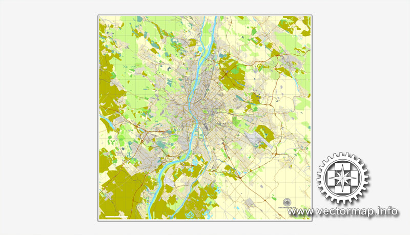
Budapest, Hungary, printable vector street City Plan map, full editable, Adobe illustrator, full vector, scalable, editable, text format street names, 18,7 mb ZIP
All streets, All buildings. Map for design, print, arts, projects, presentations,
for architects, designers and builders.
PDF, DXF, DWG, CDR and other formats – on request, same price, please, contact
Budapest, Magyarország, nyomtatható vektor utca várostérképe térkép, teljes szerkeszthető, Adobe Illustrator, a teljes vektor, méretezhető, szerkeszthető, szöveges formátumban utcanevek, 18,7 mb ZIP
Minden utcák, az épületek. Térkép a tervezés, nyomtatás, művészeti projektek, előadások,
az építészek, tervezők és építők.
PDF, DXF, DWG, CDR és más formátumok – kérésre, ugyanazon az áron, várjuk, contact
Budapest, Hungary.
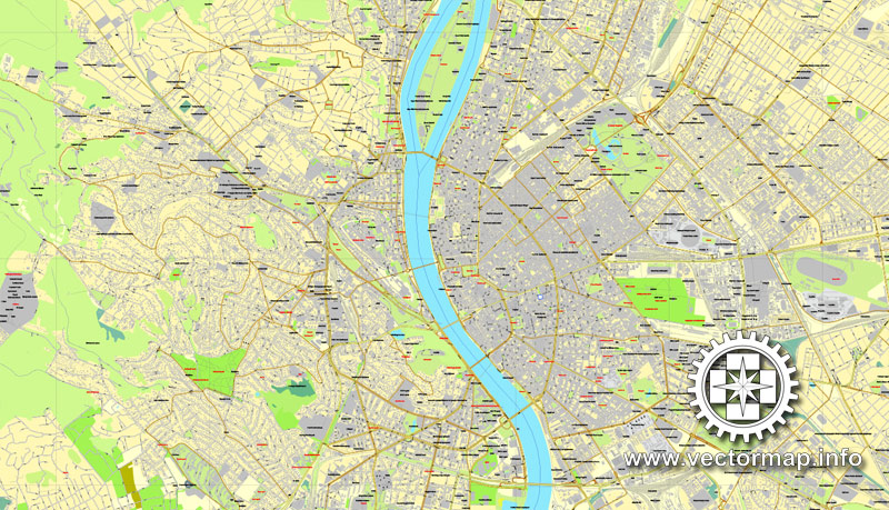
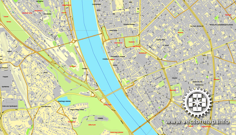
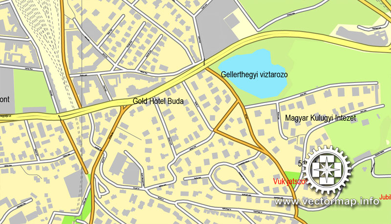
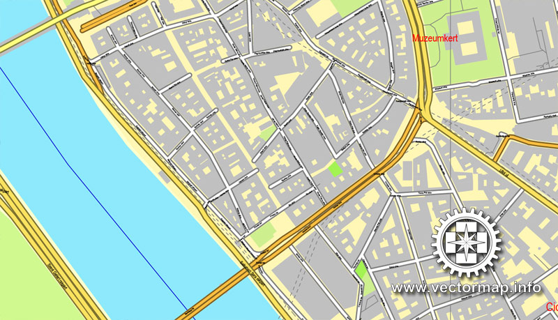
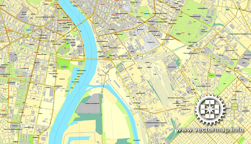
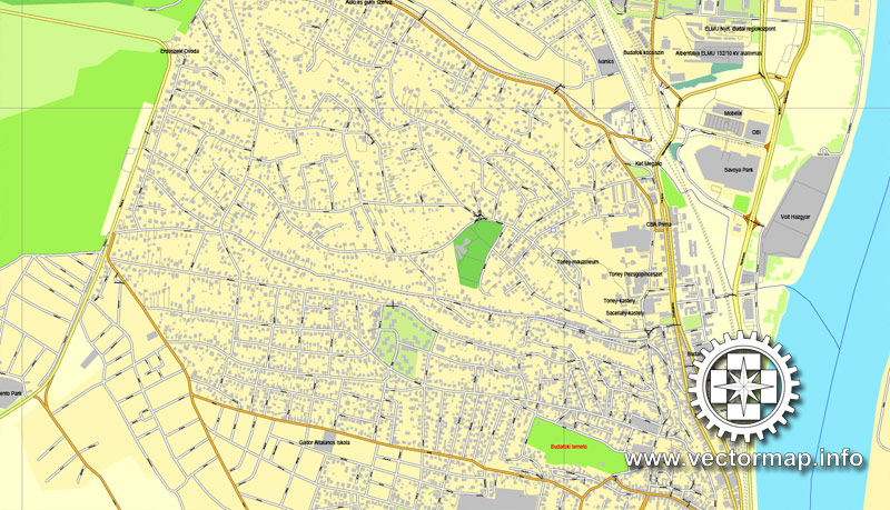
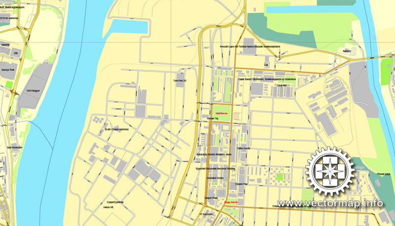
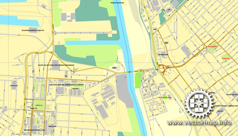
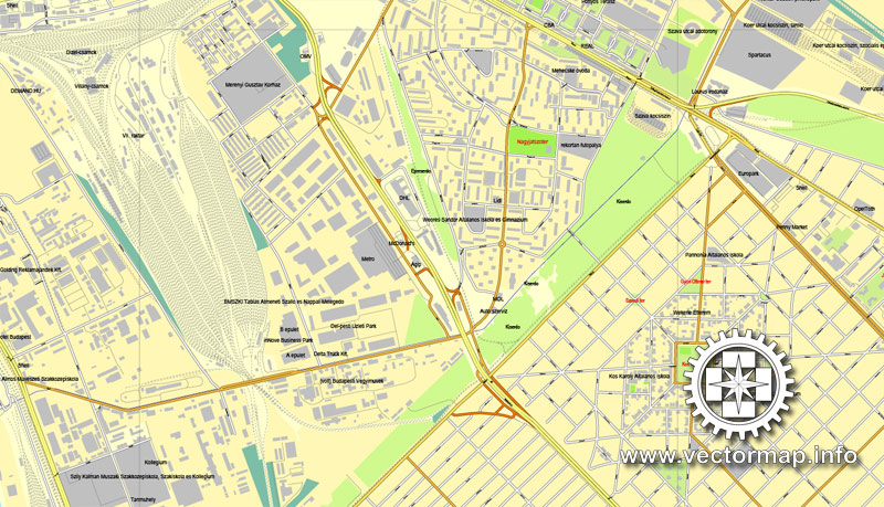
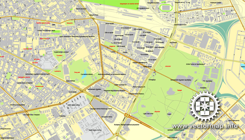
This vector map of Budapest is used as a basis for design, editing, and further printing.
This is the most detailed, exact map of Budapest for high-quality printing and polygraphy. You can always clarify the map development date by contacting us.
For your convenience, all objects on Budapest vector map are divided into layers. And the editing is very easy – colors, lines, etc.
You can easily add any objects needed (e.g. shops, salons, sale points, gas station or attraction) on any layer of Budapest vector map.
Budapest is the capital and the most populous city of Hungary, and the tenth-largest city in the European Union by population within city limits. The city had an estimated population of 1,752,704 in 2016 distributed over a land area of about 525 square kilometres (203 square miles). Budapest is both a city and county, and forms the centre of the Budapest metropolitan area, which has an area of 7,626 square kilometres (2,944 square miles) and a population of 3,303,786, comprising 33 percent of the population of Hungary.
One of the advantages of Budapest vector maps of our production is the relevance of cartographic data, we constantly update all our products.
This vector map of Budapest is used by:
designers, layout designers, printers, advertisers and architects. Our product – vector maps – is designed for further editing and printing in large formats – from @Wall format (a few meters) to A-0 and A-1, A-2, A-3.
Budapest map in vector format is used for design, urban planning, presentations and media visualizations.
Advertising and presentation map of Budapest (usually the final designer marks the routes, and puts the client’s objects (shops, saloons, gas stations etc.)
The undoubted advantage is that people will NEVER throw out this advertising product – the map. In fact, as an advertising medium, a map is the most “long-playing” of the well-known polygraphic advertising media, with the longest lifespan, and the maximum number of interactions with the customer.
For travelers, maps are sold at the airports and gas stations around the world. Often the source is our vector maps.
Take a look, who purchases our vector maps of Budapest in “Our Clients and Friends” page – these are large and small companies, from super-brands like Volvo and Starbucks, to small design studios and printing houses.
It’s very easy to work with vector maps of Budapest, even for a not very experienced designer who can turn on and off the map layers, add new objects, change the colors of fill and lines according to customer requirements.
The undoubted advantage of Budapest vector maps in printing is an excellent and detailed visualization, when customer can expand a large paper map and instantly define his location, find a landmark, an object or address on map, unlike using the popular electronic formats of Google and Yandex maps for example.
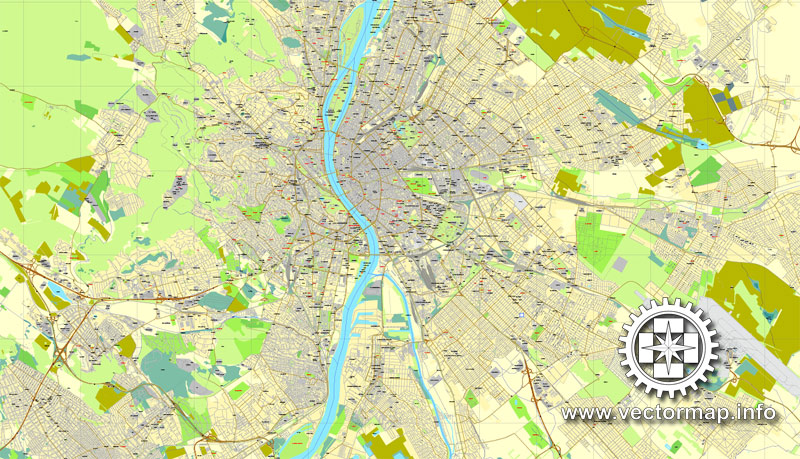
Printable vector maps of Budapest are much more convenient and efficient than any electronic maps on your smartphone, because ALL DETAILS are displayed in the entire space of Budapest map.
Useful tips on working with vector maps of cities and countries in Adobe Illustrator.
«V» – launches the Selection tool (cursor, black arrow), which makes active any vector line.
«А» – launches the Direct Selection tool (white cursor), allows you to select curve elements and drag them to the desired place.
«R» – activates the Rotate tool, which helps you rotating selected objects around the center point by 360 degrees.
«E» – gives you the opportunity to use the Eraser tool and erase unnecessary parts.
«X» – switches between Fill and Stroke in the Tools section. Try to get used to this hot key and
you will quickly understand that you can’t live and work without it.
Guides are not limited to vertical and horizontal in Adobe Illustrator. You can also create a diagonal guide for example. Moreover, you can turn any contours into guides. Select the outline and go to View > Guides > Make Guides (Create Guides), or simply press Cmd/Ctrl + 5. You can also turn the guides back into an editable object. Go to menu, View > Guides > Unlock Guides (Release Guides), select the guide you want to edit and select View > Guides > Release Guides (Reset Guides), or just press Cmd/Ctrl + Option / Alt + 5).
You will probably want to change the color scheme used on our Budapest vector map.
To quickly and effectively play with colors.
Of course, you can do it manually, all objects in our Budapest vector map are divided according to types and layers, and you can easily change the color gamma of vector objects in groups and layers.
But there is more effective way of working with the whole VECTOR MAP of Budapest and all layers:
The overview dialog «Edit colors»/«Repaint Graphic Object» (this dialog box name can change depending on the context):
If you have selected a part or a layer of Budapest vector map and open the dialog box by clicking the icon in the Control panel, on the Samples palette or the Color Catalog, or if you choose Edit > Edit Colors> Repaint Graphic Object, then the «Repaint Graphic Object» dialog box appears, and you get access to «Assign» and «Edit» tabs.
If a picture or a map fragment is not selected, and you open the dialog box by clicking the icon in the Control panel, on the Samples palette or in the Color Catalog, the «Edit Colors» dialog box appears and you can only access the «Edit» tab.
Regardless of the name at the top of the dialog box, the right-hand side always displays the color group of the current document, as well as two default color groups: Print Color and Grayscale. These color groups can be selected and used any time.
The history of Budapest began when an early Celtic settlement transformed into a Roman town of Aquincum, the capital of Lower Pannonia. The Hungarians arrived in the territory in the late 9th century. The area was pillaged by the Mongols in 1241. Buda, the settlements on the west bank of the river, became one of the centres of Renaissance humanist culture by the 15th century. The Battle of Mohács in 1526 was followed by nearly 150 years of Ottoman rule. After the reconquest of Buda in 1686, the region entered a new age of prosperity. Pest-Buda became a global city with the unification of Buda, Óbuda, and Pest on November 17, 1873, with the name ‘Budapest’ given to the new capital. Budapest also became the co-capital of the Austro-Hungarian Empire, a great power that dissolved in 1918, following World War I. The city was the focal point of the Hungarian Revolution of 1848, the Battle of Budapest in 1945, and the Hungarian Revolution of 1956.
Create and edit color groups of Budapest vector map, and also assign colors using the «Edit Colors»/ а «Repaint Graphic Object» dialog box.
A. Creating and editing of a color group on the «Edit» tab
B. Assigning colors on the «Assign» tab
C. Select a group of colors from the «Color groups» list
The option «Repaint a graphic object» in the lower part of the dialog box allows you to preview the colors on a selected layer of Vector map, or a group of elements, and specify whether its colors will be redefined when the dialog box is closed.
The main areas of the dialog box are:
«Edit»
The «Edit» tab is designed to create a new or edit the existing color groups.
The harmony rules Menu and the Color Wheel are used to conduct experiments with color harmonies. The color wheel shows how colors are related in color harmony, and the color bars allow you to view and manipulate an individual color values. In addition, you can adjust the brightness, add and remove colors, save color groups and view colors on the selected Vector Map of Budapest or a separated layers.
«Assign»
The «Assign» tab is used to view and control on how the original colors are replaced with colors from the color group like your corporate colors in the Vector Map of Budapest.
The assign color ability is provided only if the entire map, layer or fragment is selected in the document. You can specify which of new colors replace the current colors, whether the spot colors should be preserved and how colors are replaced (for example, you can replace colors completely or changing the color tone while maintaining the brightness). The «Assign» tab allows you to redefine colors in the Vector Map of Budapest, or in separate layers and fragments using the current color group or reducing the number of colors in the current Vector Map.
Color groups
Is a list of all saved color groups for current document (the same groups appear in the «Samples» palette). You can edit and delete the existing color groups, as well as creating a new ones using the list of “Color Groups” in the dialog box. All changes appear in the «Samples» palette.
The highlighted color group shows, which color group is currently edited.
Any color group can be selected and edited, or used to redefine the colors in the selected vector map of Budapest, its fragments or elements.
Saving a color group adds this group to the specified list.
Opening the «Edit Colors»/«Repaint Graphic Object» dialog box.
Open the «Edit Colors»/«Repaint Graphic Object» dialog box using one of the following methods:
«Edit»> «Edit Colors»> «Repaint Graphic object» or «Repaint With Style».
Use these commands if you need to edit the colors in the selected vector map of Budapest.
«Repaint Graphic object» button on the «Control» panel.
Use this button if you need to adjust colors of Budapest vector map using the а «Repaint graphic object» dialog box.
The specified button is available if the selected vector map or its fragment contains two or more colors.
Note. This color editing method is convenient for global color adjustment in a vector map, if global colors were not used when creating a Map of Budapest.
The «Edit colors» button or «Edit or apply colors» on the «Color Catalog» palette
Click this button if you need to edit colors on the «Color Catalog» palette or edit and then apply them to the selected Vector Map of Budapest or its fragment.
The «Edit color group» button or «Edit or apply color group» on the «Samples» palette.
Click this button if you need to edit the colors in the specific color group or edit and apply them to the selected Vector Map of Budapest or a group of its elements, for example, the whole layer “Streets and lines”. You can also double-click the color group in the Samples panel to open the dialog box.
If the map file is too large and your computer freezes or even can’t open it quickly:
1. Try to reduce the color resolution of the video card (display) to 256 colors while working with a large map.
2. Using Windows Task Manager, select all the application you don’t need, while working with map, just turn them off.
3. Launch Adobe Illustrator. (DO NOT OPEN the vector map file)
4. Start the Windows Task Manager using administrator rights > Find the “Illustrator” process > set the «real time» priority,
5. Open the file. When you see the LEGACY FONT popup window – click “OK” (do not update). You can restore the TEXT later.
6. Can also be useful: When file is opened – Edit > Settings > Basic Settings > disable smoothing. /// It looks scary, but works quickly)))
We recommend saving the file in Adobe Illustrator 10 version. It’s much more stable when working with VERY BIG size files.
Budapest is an Alpha- global city with strengths in commerce, finance, media, art, fashion, research, technology, education, and entertainment. It is Hungary’s financial centre and the highest ranked Central and Eastern European city on Innovation Cities Top 100 index, as well ranked as the second fastest-developing urban economy in Europe. Budapest is host to many major international organization’s regional offices, including the United Nations,ICDT and the Russian International Investment Bank. Furthermore it is the headquarters of the European Institute of Innovation and Technology, the European Police College and the first foreign office of the China Investment Promotion Agency. Over 40 colleges and universities are located in Budapest, including the Eötvös Loránd University, Semmelweis University and the notable Budapest University of Technology and Economics. Opened in 1896, the city’s subway system, the Budapest Metro, serves 1.27 million, while the Budapest Tram Network serves 1.08 million passengers daily.
Budapest is cited as one of the most beautiful cities in Europe, ranked as “the world’s second best city” by Condé Nast Traveler, and “Europe’s 7th most idyllic place to live” by Forbes. Among Budapest’s important museums and cultural institutions is the Museum of Fine Arts. Further famous cultural institutions are the Hungarian National Museum, House of Terror, Franz Liszt Academy of Music, Hungarian State Opera House and National Széchényi Library. The central area of the city along the Danube River is classified as a UNESCO World Heritage Site and has many notable monuments, including the Hungarian Parliament, Buda Castle, Fisherman’s Bastion, Gresham Palace, Széchenyi Chain Bridge, Matthias Church and the Liberty Statue. Other famous landmarks include Andrássy Avenue, St. Stephen’s Basilica, Heroes’ Square, the Great Market Hall, the Nyugati Railway Station built by the Eiffel Company of Paris in 1877 and the second-oldest metro line in the world, the Millennium Underground Railway. The city also has around 80 geothermal springs, the largest thermal water cave system, second largest synagogue, and third largest Parliament building in the world. Budapest attracts 4.4 million international tourists per year, making it a popular destination in Europe.
Topography
Budapest, strategically placed at the centre of the Carpathian Basin, lies on an ancient route linking the hills of Transdanubia with the Great Plain. By road it is 216 kilometres (134 mi) south-east of Vienna, 545 kilometres (339 mi) south of Warsaw, 1,565 kilometres (972 mi) south-west of Moscow, 1,122 kilometres (697 mi) north of Athens, 788 kilometres (490 mi) north-east of Milan, and 443 kilometres (275 mi) south-east of Prague.
The 525 square kilometres (203 sq mi) area of Budapest lies in Central Hungary, surrounded by settlements of the agglomeration in Pest county. The capital extends 25 and 29 km (16 and 18 mi) in the north-south, east-west direction respectively. The Danube enters the city from the north; later it encircles two islands, Óbuda Island and Margaret Island. The third island Csepel Island is the largest of the Budapest Danube islands, however only its northernmost tip is within city limits. The river that separates the two parts of the city is 230 m (755 ft) wide at its narrowest point in Budapest. Pest lies on the flat terrain of the Great Plain while Buda is rather hilly.
The wide Danube was always fordable at this point because of a small number of islands in the middle of the river. The city has marked topographical contrasts: Buda is built on the higher river terraces and hills of the western side, while the considerably larger Pest spreads out on a flat and featureless sand plain on the river’s opposite bank. Pest’s terrain rises with a slight eastward gradient, so the easternmost parts of the city lie at the same altitude as Buda’s smallest hills, notably Gellért Hill and Castle Hill.
The Buda hills consist mainly of limestone and dolomite, the water created speleothems, the most famous ones being the Pálvölgyi cave (total length 7,200 m or 23,600 ft) and the Szemlőhegyi cave (total length 2,200 m or 7,200 ft). The hills were formed in the Triassic Period. The highest point of the hills and of Budapest is János hill, at 527 metres (1,729 feet) above sea level. The lowest point is the line of the Danube which is 96 metres (315 feet) above sea level. Budapest is also rich in green areas. Of the 525 square kilometres (203 square miles) occupied by the city, 83 square kilometres (32 square miles) is green area, park and forest. The forests of Buda hills are environmentally protected.
The city’s importance in terms of traffic is very central, because all major European roads and European railway lines lead to Budapest. The Danube was and is still an important water-way and this region in the centre of the Carpathian Basin lies at the cross-roads of trade routes. Budapest is one of only two capital cities in the world which has thermal springs (the other being Reykjavík in Iceland). Some 125 springs produce 70 million litres (15,000,000 imperial gallons; 18,000,000 US gallons) of thermal water a day, with temperatures ranging up to 58 Celsius. Some of these waters have medicinal effects due to their medically valuable mineral contents.
Budapest
Capital of Hungary
Budapest, Hungary’s capital, is bisected by the River Danube, and the 19th-century Chain Bridge connects its hilly Buda district with flat Pest. A funicular runs up Castle Hill to Buda’s Old Town, where the Budapest History Museum traces life from Roman times onwards. Trinity Square is home to 13th-century Matthias Church and the turrets of the Fishermen’s Bastion, which offer sweeping views.
Small guide: How to work with the vector map?
You can: Mass select objects by type and color – for example, the objects type “building” (they are usually dark gray) – and remove them from the map, if you do not need them in your print or design project. You can also easily change the thickness of lines (streets), just bulk selection the road by the line color.
The streets are separated by type, for example, type “residential road” are usually white with a gray stroke. Highway usually orange with a brown or dark gray stroke.
It is easy to change the font of inscriptions, all or each individually. Also, just can be make and any other manipulation of objects on the vector map in Adobe illustrator format.
Important: All the proportions on the map are true, that is, the relative sizes of the objects are true, because Map is based on an accurate GPS projection, and It transated into the (usual for all) the Mercator projection.
You can easily change the color, stroke and fill of any object on the map, zoom without loss of quality Image Verification.
Select object

Bulk selection the same objects on the vector map

See the bulk selected objects on the vector map

Bulk delete buildungs from the vector map

Select residencial road (small street) on the vector map

Bulk selection the same lines (streets, roads) on the full map

Create fat lines of the streets on the vector maps (bulk action) 1

Create fat lines of the streets on the vector maps (bulk action) 2

Create fat lines of the streets on the vector maps (bulk action) 3

You can easily change the color, stroke and fill of any object on the map, zoom without loss of quality Image Verification.

 Author: Kirill Shrayber, Ph.D. FRGS
