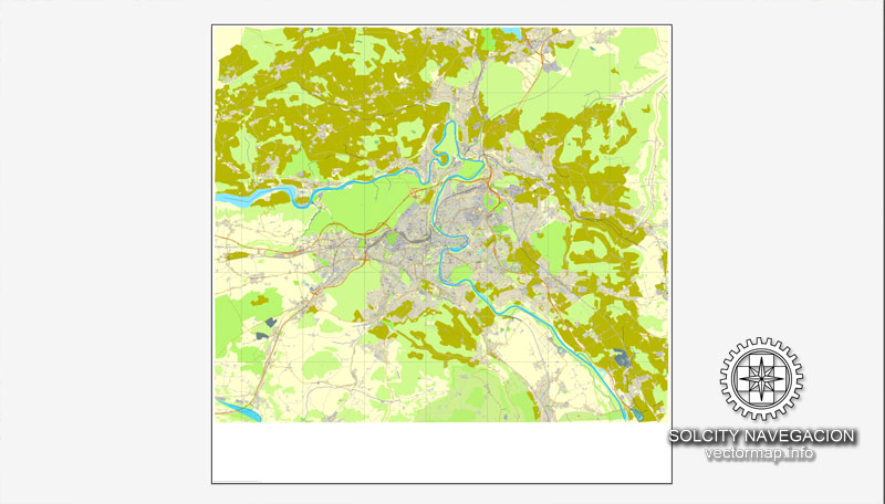
Bern, Switzerland printable vector street full City Plan map, full editable, Adobe Illustrator, full vector, scalable, editable, text format street names, 5,6 mb ZIP
All streets, all buildings.
PDF, DXF and other formats – on demand, same price, please, contact
DXF, DWG, CDR and other formats – on request, same price, please, contact
Bern, Switzerland.
This vector map of Bern city is used as a basis for design, editing, and further printing.
This is the most detailed, exact map of Bern city for high-quality printing and polygraphy. You can always clarify the map development date by contacting us.
For your convenience, all objects on Bern vector city map are divided into layers. And the editing is very easy – colors, lines, etc.
You can easily add any objects needed (e.g. shops, salons, sale points, gas station or attraction) on any layer of Bern vector map.
Bern or Berne is the de facto capital of Switzerland, referred to by the Swiss as their (e.g. in German) Bundesstadt, or “federal city”. With a population of 142,656 (March 2018), Bern is the fifth-most populous city in Switzerland. The Bern agglomeration, which includes 36 municipalities, had a population of 406,900 in 2014. The metropolitan area had a population of 660,000 in 2000. Bern is also the capital of the canton of Bern, the second-most populous of Switzerland’s cantons.
One of the advantages of Bern city vector maps of our production is the relevance of cartographic data, we constantly update all our products.
This vector map of Bern city is used by:
designers, layout designers, printers, advertisers and architects. Our product – vector maps – is designed for further editing and printing in large formats – from @Wall format (a few meters) to A-0 and A-1, A-2, A-3.
The Bern city map in vector format is used for design, urban planning, presentations and media visualizations.
The advertising and presentation map of Bern city (usually the final designer marks the routes, and puts the client’s objects (shops, saloons, gas stations etc.)
The undoubted advantage is that people will NEVER throw out this advertising product – the map. In fact, as an advertising medium, a city map is the most “long-playing” of the well-known polygraphic advertising media, with the longest lifespan, and the maximum number of interactions with the customer.
The official language in Bern is (the Swiss variety of Standard) German, but the most-spoken language is an Alemannic Swiss German dialect, Bernese German.
In 1983, the historic old town (in German: Altstadt) in the centre of Bern became a UNESCO World Heritage Site.
For travelers, maps are sold at the airports and gas stations around the world. Often the source is our vector maps.
Take a look, who purchases our vector maps of Bern city in “Our Clients and Friends” page – these are large and small companies, from super-brands like Volvo and Starbucks, to small design studios and printing houses.
It’s very easy to work with vector maps of Bern city, even for a not very experienced designer who can turn on and off the map layers, add new objects, change the colors of fill and lines according to customer requirements.
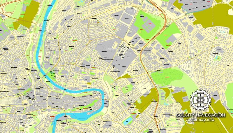
The undoubted advantage of Bern city vector maps in printing is an excellent and detailed visualization, when customer can expand a large paper map and instantly define his location, find a landmark, an object or address on map, unlike using the popular electronic formats of Google and Yandex maps for example.
Printable vector maps of Bern city are much more convenient and efficient than any electronic maps on your smartphone, because ALL DETAILS are displayed in the entire space of Bern city map.
Useful tips on working with vector maps of cities and countries in Adobe Illustrator.
«V» – launches the Selection tool (cursor, black arrow), which makes active any vector line.
«А» – launches the Direct Selection tool (white cursor), allows you to select curve elements and drag them to the desired place.
«R» – activates the Rotate tool, which helps you rotating selected objects around the center point by 360 degrees.
«E» – gives you the opportunity to use the Eraser tool and erase unnecessary parts.
«X» – switches between Fill and Stroke in the Tools section. Try to get used to this hot key and
you will quickly understand that you can’t live and work without it.
Geography and climate
Topography
Bern lies on the Swiss plateau in the canton of Bern, slightly west of the centre of Switzerland and 20 km (12 mi) north of the Bernese Alps. The countryside around Bern was formed by glaciers during the most recent ice age. The two mountains closest to Bern are Gurten with a height of 864 m (2,835 ft) and Bantiger with a height of 947 m (3,107 ft). The site of the old observatory in Bern is the point of origin of the CH1903 coordinate system at 46°57′08.66″N 7°26′22.50″E.
Guides are not limited to vertical and horizontal in Adobe Illustrator. You can also create a diagonal guide for example. Moreover, you can turn any contours into guides. Select the outline and go to View > Guides > Make Guides (Create Guides), or simply press Cmd/Ctrl + 5. You can also turn the guides back into an editable object. Go to menu, View > Guides > Unlock Guides (Release Guides), select the guide you want to edit and select View > Guides > Release Guides (Reset Guides), or just press Cmd/Ctrl + Option / Alt + 5).
You will probably want to change the color scheme used on our Bern vector city map.
To quickly and effectively play with colors.
Of course, you can do it manually, all objects in our Bern city vector map are divided according to types and layers, and you can easily change the color gamma of vector objects in groups and layers.
The city was originally built on a hilly peninsula surrounded by the river Aare, but outgrew natural boundaries by the 19th century. A number of bridges have been built to allow the city to expand beyond the Aare.
Bern is built on very uneven ground. An elevation difference of several metres exists between the inner city districts on the Aare (Matte, Marzili) and the higher ones (Kirchenfeld, Länggasse).
But there is more effective way of working with the whole VECTOR MAP of Bern city and all layers:
The overview dialog «Edit colors»/«Repaint Graphic Object» (this dialog box name can change depending on the context):
If you have selected a part or a layer of Bern city vector map and open the dialog box by clicking the icon in the Control panel, on the Samples palette or the Color Catalog, or if you choose Edit > Edit Colors> Repaint Graphic Object, then the «Repaint Graphic Object» dialog box appears, and you get access to «Assign» and «Edit» tabs.
If a picture or a map fragment is not selected, and you open the dialog box by clicking the icon in the Control panel, on the Samples palette or in the Color Catalog, the «Edit Colors» dialog box appears and you can only access the «Edit» tab.
Bern has an area, as of 2009, of 51.62 km2 (19.93 sq mi). Of this area, 9.79 km2 (3.78 sq mi) or 19.0% is used for agricultural purposes, while 17.33 km2 (6.69 sq mi) or 33.6% is forested. Of the rest of the land, 23.25 km2 (8.98 sq mi) or 45.0% is settled (buildings or roads), 1.06 km2 (0.41 sq mi) or 2.1% is either rivers or lakes, and 0.16 km2 (0.062 sq mi) or 0.3% is unproductive land.
Regardless of the name at the top of the dialog box, the right-hand side always displays the color group of the current document, as well as two default color groups: Print Color and Grayscale. These color groups can be selected and used any time.
Create and edit color groups of Bern city vector map, and also assign colors using the «Edit Colors»/ а «Repaint Graphic Object» dialog box.
A. Creating and editing of a color group on the «Edit» tab
B. Assigning colors on the «Assign» tab
C. Select a group of colors from the «Color groups» list
The option «Repaint a graphic object» in the lower part of the dialog box allows you to preview the colors on a selected layer of Vector map, or a group of elements, and specify whether its colors will be redefined when the dialog box is closed.
The main areas of the dialog box are:
«Edit»
The «Edit» tab is designed to create a new or edit the existing color groups.
The harmony rules Menu and the Color Wheel are used to conduct experiments with color harmonies. The color wheel shows how colors are related in color harmony, and the color bars allow you to view and manipulate an individual color values. In addition, you can adjust the brightness, add and remove colors, save color groups and view colors on the selected Vector Map of Bern city or a separated layers.
Of the developed, 3.6% consists of industrial buildings, 21.7% housing and other buildings, and 12.6% is devoted to transport infrastructure. Power and water infrastructure, as well as other special developed areas, made up 1.1% of the city, while another 6.0% consists of parks, green belts, and sports fields; 32.8% of the total land area is heavily forested. Of the agricultural land, 14.3% is used for growing crops and 4.0% is designated to be used as pastures. The rivers and streams provide all the water in the municipality.
«Assign»
The «Assign» tab is used to view and control on how the original colors are replaced with colors from the color group like your corporate colors in the Vector Map of Bern city.
The assign color ability is provided only if the entire map, layer or fragment is selected in the document. You can specify which of new colors replace the current colors, whether the spot colors should be preserved and how colors are replaced (for example, you can replace colors completely or changing the color tone while maintaining the brightness). The «Assign» tab allows you to redefine colors in the Vector Map of Bern city, or in separate layers and fragments using the current color group or reducing the number of colors in the current Vector Map.
Color groups
Is a list of all saved color groups for current document (the same groups appear in the «Samples» palette). You can edit and delete the existing color groups, as well as creating a new ones using the list of “Color Groups” in the dialog box. All changes appear in the «Samples» palette.
The highlighted color group shows, which color group is currently edited.
Any color group can be selected and edited, or used to redefine the colors in the selected vector map of Bern city, its fragments or elements.
Saving a color group adds this group to the specified list.
Opening the «Edit Colors»/«Repaint Graphic Object» dialog box.
Open the «Edit Colors»/«Repaint Graphic Object» dialog box using one of the following methods:
«Edit»> «Edit Colors»> «Repaint Graphic object» or «Repaint With Style».
Use these commands if you need to edit the colors in the selected vector map of Bern city.
«Repaint Graphic object» button on the «Control» panel.
Use this button if you need to adjust colors of Bern city vector map using the а «Repaint graphic object» dialog box.
The specified button is available if the selected vector map or its fragment contains two or more colors.
Note. This color editing method is convenient for global color adjustment in a vector map, if global colors were not used when creating a City Map of Bern.
Small guide: How to work with the vector map?
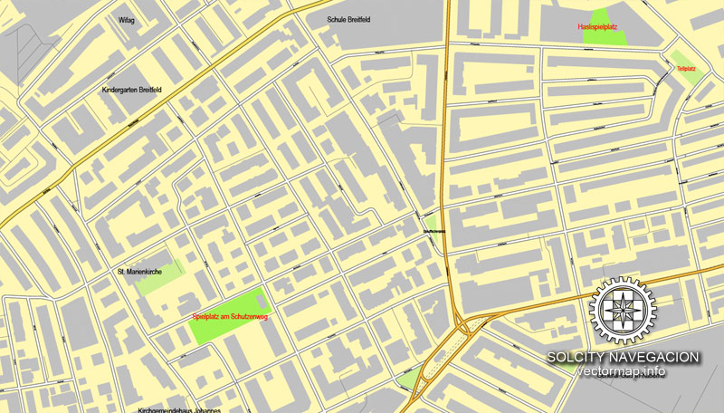
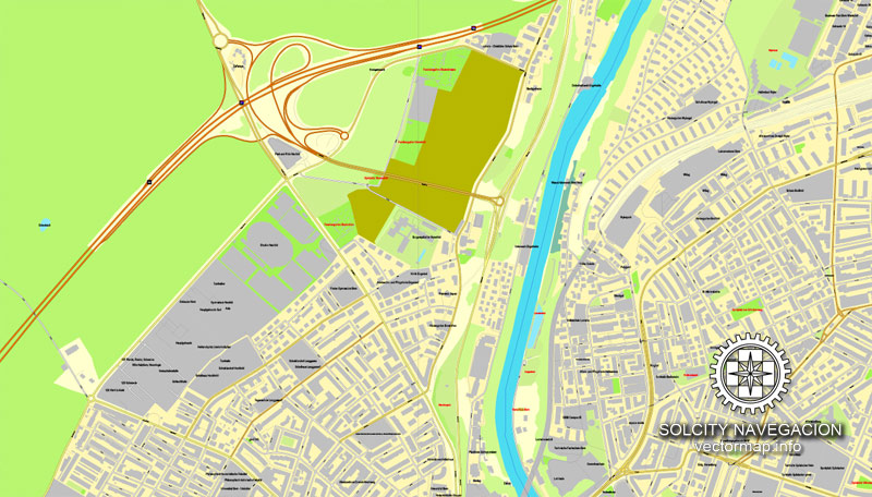
You can: Mass select objects by type and color – for example, the objects type “building” (they are usually dark gray) – and remove them from the map, if you do not need them in your print or design project. You can also easily change the thickness of lines (streets), just bulk selection the road by the line color.
The streets are separated by type, for example, type “residential road” are usually white with a gray stroke. Highway usually orange with a brown or dark gray stroke.
It is easy to change the font of inscriptions, all or each individually. Also, just can be make and any other manipulation of objects on the vector map in Adobe illustrator format.
Important: All the proportions on the map are true, that is, the relative sizes of the objects are true, because Map is based on an accurate GPS projection, and It transated into the (usual for all) the Mercator projection.
You can easily change the color, stroke and fill of any object on the map, zoom without loss of quality Image Verification.
Select object

Bulk selection the same objects on the vector map

See the bulk selected objects on the vector map

Bulk delete buildungs from the vector map

Select residencial road (small street) on the vector map

Bulk selection the same lines (streets, roads) on the full map

Create fat lines of the streets on the vector maps (bulk action) 1

Create fat lines of the streets on the vector maps (bulk action) 2

Create fat lines of the streets on the vector maps (bulk action) 3

You can easily change the color, stroke and fill of any object on the map, zoom without loss of quality Image Verification.

 Author: Kirill Shrayber, Ph.D. FRGS

 Street Map editable Adobe Illustrator in layers")