Printable PDF Vector Map Belgium Admin, exact Mercator Projection, editable Layered Adobe PDF, 1 Mb ZIP.
Exact boundaries Country, Provinces and Counties with names. Map for publishing, design, printing, publications, arts, projects, presentations, for architects, designers, and builders, business, logistics. The most accurate map of this level.
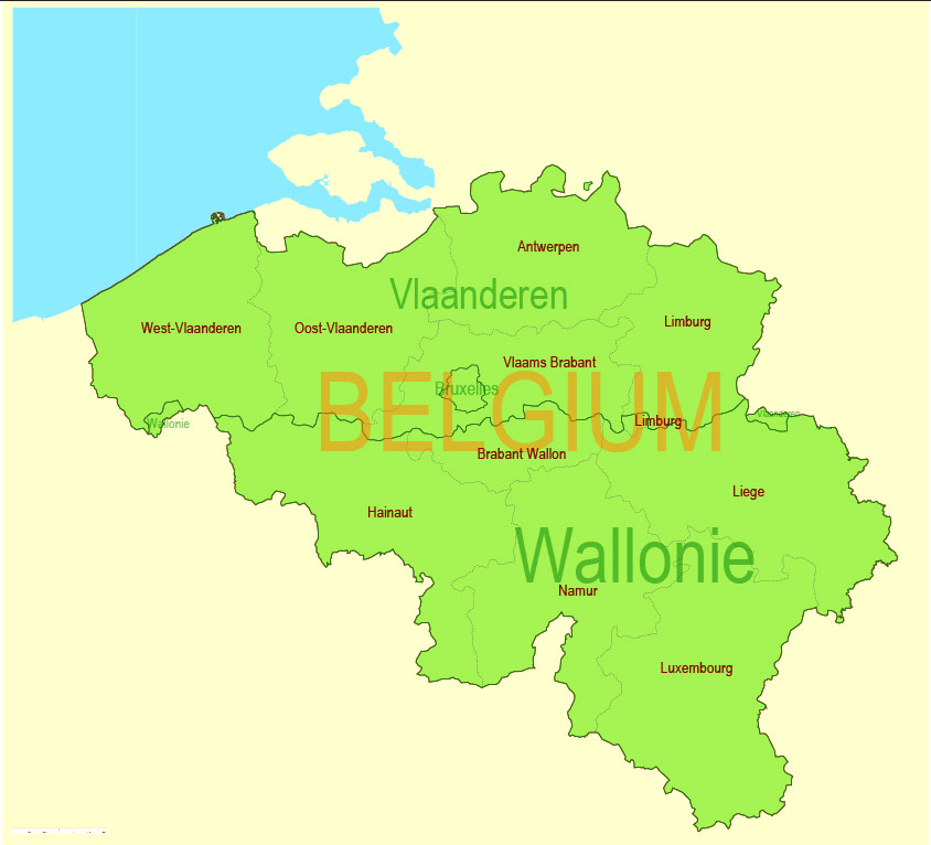
Layers: Ground_sea, Provinces, Names_provinces, Counties, Names_counties, Names_country, State_boundaries
Text format all names
DWG, DXF, CDR, ESRI Shapes, and other formats – by request, the same price, please contact.
Belgium.
This vector map of Belgium is used as a basis for design, editing, and further printing.
This is the most detailed, exact map of Belgium for high-quality printing and polygraphy. You can always clarify the map development date by contacting us.
For your convenience, all objects on Belgium vector map are divided into layers. And the editing is very easy – colors, lines, etc.
You can easily add any objects needed (e.g. shops, salons, sale points, gas station or attraction) on any layer of Belgium vector map.
Belgium is a country in Western Europe bordered by the Netherlands to the north, Germany to the east, Luxembourg to the southeast, France to the southwest, and the North Sea to the northwest. It covers an area of 30,528 square kilometres (11,787 sq mi) and has a population of more than 11.4 million. The capital and largest city is Brussels; other major cities are Antwerp, Ghent, Charleroi and Liège.
One of the advantages of Belgium vector maps of our production is the relevance of cartographic data, we constantly update all our products.
This vector map of Belgium is used by:
designers, layout designers, printers, advertisers and architects. Our product – vector maps – is designed for further editing and printing in large formats – from @Wall format (a few meters) to A-0 and A-1, A-2, A-3.
The Belgium map in vector format is used for design, urban planning, presentations and media visualizations.
The advertising and presentation map of Belgium (usually the final designer marks the routes, and puts the client’s objects (shops, saloons, gas stations etc.)
The undoubted advantage is that people will NEVER throw out this advertising product – the map. In fact, as an advertising medium, a map is the most “long-playing” of the well-known polygraphic advertising media, with the longest lifespan, and the maximum number of interactions with the customer.
For travelers, maps are sold at the airports and gas stations around the world. Often the source is our vector maps.
Take a look, who purchases our vector maps of Belgium in “Our Clients and Friends” page – these are large and small companies, from super-brands like Volvo and Starbucks, to small design studios and printing houses.
It’s very easy to work with vector maps of Belgium city, even for a not very experienced designer who can turn on and off the map layers, add new objects, change the colors of fill and lines according to customer requirements.
The undoubted advantage of Belgium vector maps in printing is an excellent and detailed visualization, when customer can expand a large paper map and instantly define his location, find a landmark, an object or address on map, unlike using the popular electronic formats of Google and Yandex maps for example.
Printable vector maps of Belgium are much more convenient and efficient than any electronic maps on your smartphone because ALL DETAILS are displayed in the entire space of Belgium map.
Useful tips on working with vector maps of cities and countries in Adobe Illustrator.
«V» – launches the Selection tool (cursor, black arrow), which makes active any vector line.
«А» – launches the Direct Selection tool (white cursor), allows you to select curve elements and drag them to the desired place.
«R» – activates the Rotate tool, which helps you rotating selected objects around the center point by 360 degrees.
«E» – gives you the opportunity to use the Eraser tool and erase unnecessary parts.
«X» – switches between Fill and Stroke in the Tools section. Try to get used to this hot key and
you will quickly understand that you can’t live and work without it.
Guides are not limited to vertical and horizontal in Adobe Illustrator. You can also create a diagonal guide for example. Moreover, you can turn any contours into guides. Select the outline and go to View > Guides > Make Guides (Create Guides), or simply press Cmd/Ctrl + 5. You can also turn the guides back into an editable object. Go to menu, View > Guides > Unlock Guides (Release Guides), select the guide you want to edit and select View > Guides > Release Guides (Reset Guides), or just press Cmd/Ctrl + Option / Alt + 5).
You will probably want to change the color scheme used on our Belgium vector map.
To quickly and effectively play with colors.
Of course, you can do it manually, all objects in our Belgium vector map are divided according to types and layers, and you can easily change the color gamma of vector objects in groups and layers.
But there is more effective way of working with the whole VECTOR MAP of Belgium and all layers:
The overview dialog «Edit colors»/«Repaint Graphic Object» (this dialog box name can change depending on the context):
If you have selected a part or a layer of Belgium vector map and open the dialog box by clicking the icon in the Control panel, on the Samples palette or the Color Catalog, or if you choose Edit > Edit Colors> Repaint Graphic Object, then the «Repaint Graphic Object» dialog box appears, and you get access to «Assign» and «Edit» tabs.
If a picture or a map fragment is not selected, and you open the dialog box by clicking the icon in the Control panel, on the Samples palette or in the Color Catalog, the «Edit Colors» dialog box appears and you can only access the «Edit» tab.
Regardless of the name at the top of the dialog box, the right-hand side always displays the color group of the current document, as well as two default color groups: Print Color and Grayscale. These color groups can be selected and used any time.
Create and edit color groups of Belgium vector map, and also assign colors using the «Edit Colors»/ а «Repaint Graphic Object» dialog box.
A. Creating and editing of a color group on the «Edit» tab
B. Assigning colors on the «Assign» tab
C. Select a group of colors from the «Color groups» list
The option «Repaint a graphic object» in the lower part of the dialog box allows you to preview the colors on a selected layer of Vector map, or a group of elements, and specify whether its colors will be redefined when the dialog box is closed.
The main areas of the dialog box are:
«Edit»
The «Edit» tab is designed to create a new or edit the existing color groups.
The harmony rules Menu and the Color Wheel are used to conduct experiments with color harmonies. The color wheel shows how colors are related in color harmony, and the color bars allow you to view and manipulate an individual color values. In addition, you can adjust the brightness, add and remove colors, save color groups and view colors on the selected Vector Map of Belgium or a separated layers.
«Assign»
The «Assign» tab is used to view and control on how the original colors are replaced with colors from the color group like your corporate colors in the Vector Map of Belgium city.
The assign color ability is provided only if the entire map, layer or fragment is selected in the document. You can specify which of new colors replace the current colors, whether the spot colors should be preserved and how colors are replaced (for example, you can replace colors completely or changing the color tone while maintaining the brightness). The «Assign» tab allows you to redefine colors in the Vector Map of Belgium city, or in separate layers and fragments using the current color group or reducing the number of colors in the current Vector Map.
Color groups
Is a list of all saved color groups for current document (the same groups appear in the «Samples» palette). You can edit and delete the existing color groups, as well as creating a new ones using the list of “Color Groups” in the dialog box. All changes appear in the «Samples» palette.
The highlighted color group shows, which color group is currently edited.
Any color group can be selected and edited, or used to redefine the colors in the selected vector map of Belgium city, its fragments or elements.
Saving a color group adds this group to the specified list.
Opening the «Edit Colors»/«Repaint Graphic Object» dialog box.
Open the «Edit Colors»/«Repaint Graphic Object» dialog box using one of the following methods:
«Edit»> «Edit Colors»> «Repaint Graphic object» or «Repaint With Style».
Use these commands if you need to edit the colors in the selected vector map of Belgium city.
«Repaint Graphic object» button on the «Control» panel.
Use this button if you need to adjust colors of Belgium vector map using the а «Repaint graphic object» dialog box.
The specified button is available if the selected vector map or its fragment contains two or more colors.
Note. This color editing method is convenient for global color adjustment in a vector map, if global colors were not used when creating a Map of Belgium.
The «Edit colors» button or «Edit or apply colors» on the «Color Catalog» palette
Click this button if you need to edit colors on the «Color Catalog» palette or edit and then apply them to the selected Vector Map of Belgium or its fragment.
The «Edit color group» button or «Edit or apply color group» on the «Samples» palette.
Click this button if you need to edit the colors in the specific color group or edit and apply them to the selected Vector Map of Belgium or a group of its elements, for example, the whole layer “Streets and lines”. You can also double-click the color group in the Samples panel to open the dialog box.
If the map file is too large and your computer freezes or even can’t open it quickly:
1. Try to reduce the color resolution of the video card (display) to 256 colors while working with a large map.
2. Using Windows Task Manager, select all the application you don’t need, while working with map, just turn them off.
3. Launch Adobe Illustrator. (DO NOT OPEN the vector map file)
4. Start the Windows Task Manager using administrator rights > Find the “Illustrator” process > set the «real time» priority,
5. Open the file. When you see the LEGACY FONT popup window – click “OK” (do not update). You can restore the TEXT later.
6. Can also be useful: When file is opened – Edit > Settings > Basic Settings > disable smoothing. /// It looks scary, but works quickly)))
We recommend saving the file in Adobe Illustrator 10 version. It’s much more stable when working with VERY BIG size files.
The sovereign state of Belgium is a federal constitutional monarchy with a parliamentary system of governance. Its institutional organisation is complex and is structured on both regional and linguistic grounds. It is divided into three highly autonomous regions: Flanders in the north, Wallonia in the south, and the Brussels-Capital Region. Brussels is both the smallest and richest region in terms of GDP per capita. It is also the most densely populated area in Belgium.
Belgium is home to two main linguistic groups or Communities: the Dutch-speaking, mostly Flemish Community, which constitutes about 59 percent of the population, and the French-speaking Community, which comprises about 40 percent of all Belgians. Additionally, a small German-speaking Community, numbering around one percent, exists in the East Cantons. The Brussels-Capital Region is officially bilingual (French and Dutch), although French is the dominant language of the population. Belgium’s linguistic diversity and related political conflicts are reflected in its political history and complex system of governance, made up of six different governments.
Historically, Belgium was part of an area known as the Low Countries, a somewhat larger region than the current Benelux group of states that also included parts of northern France and western Germany. Its name is derived from the Latin word Belgica, after the Roman province of Gallia Belgica. From the end of the Middle Ages until the 17th century, the area of Belgium was a prosperous and cosmopolitan centre of commerce and culture. Between the 16th and early 19th centuries, Belgium served as the battleground between many European powers, earning the moniker the “Battlefield of Europe”, a reputation strengthened by both world wars. The country emerged in 1830 following the Belgian Revolution when it seceded from the Netherlands.
Belgium participated in the Industrial Revolution and, during the course of the 20th century, possessed a number of colonies in Africa. The second half of the 20th century was marked by rising tensions between the Dutch-speaking and the French-speaking citizens fueled by differences in language and culture and the unequal economic development of Flanders and Wallonia. This continuing antagonism has led to several far-reaching reforms, resulting in a transition from a unitary to a federal arrangement during the period from 1970 to 1993. Despite the reforms, tensions between the groups have remained, if not increased; there is significant separatism particularly among the Flemish; controversial language laws exist such as the municipalities with language facilities; and the formation of a coalition government took 18 months following the June 2010 federal election, a world record. Unemployment in Wallonia is more than double that of Flanders, which boomed after the war.
Belgium is one of the six founding countries of the European Union and hosts the official seats of the European Commission, the Council of the European Union, and the European Council, as well as a seat of the European Parliament in the country’s capital, Brussels. Belgium is also a founding member of the Eurozone, NATO, OECD, and WTO, and a part of the trilateral Benelux Union and the Schengen Area. Brussels hosts several of the EU’s official seats as well as the headquarters of many major international organizations such as NATO.
Belgium is a developed country, with an advanced high-income economy. The country achieves very high standards of living, life quality, healthcare, education, and is categorized as “very high” in the Human Development Index. It also ranks as one of the safest or most peaceful countries in the world.
Geography
Belgium shares borders with France (620 km), Germany (167 km), Luxembourg (148 km) and the Netherlands (450 km). Its total surface, including water area, is 30,528 square kilometres from which land area alone 30,278 km2. It lies between latitudes 49°30 and 51°30 N, and longitudes 2°33 and 6°24 E.
Polders along the Yser river.
Belgium has three main geographical regions; the coastal plain in the northwest and the central plateau both belong to the Anglo-Belgian Basin, and the Ardennes uplands in the southeast to the Hercynian orogenic belt. The Paris Basin reaches a small fourth area at Belgium’s southernmost tip, Belgian Lorraine.
The coastal plain consists mainly of sand dunes and polders. Further inland lies a smooth, slowly rising landscape irrigated by numerous waterways, with fertile valleys and the northeastern sandy plain of the Campine (Kempen). The thickly forested hills and plateaux of the Ardennes are more rugged and rocky with caves and small gorges. Extending westward into France, this area is eastwardly connected to the Eifel in Germany by the High Fens plateau, on which the Signal de Botrange forms the country’s highest point at 694 metres (2,277 ft).
The climate is maritime temperate with significant precipitation in all seasons (Köppen climate classification: Cfb), like most of northwest Europe. The average temperature is lowest in January at 3 °C (37.4 °F) and highest in July at 18 °C (64.4 °F). The average precipitation per month varies between 54 millimetres (2.1 in) for February and April, to 78 mm (3.1 in) for July. Averages for the years 2000 to 2006 show daily temperature minimums of 7 °C (44.6 °F) and maximums of 14 °C (57.2 °F) and monthly rainfall of 74 mm (2.9 in); these are about 1 °C and nearly 10 millimetres above last century’s normal values, respectively.
Phytogeographically, Belgium is shared between the Atlantic European and Central European provinces of the Circumboreal Region within the Boreal Kingdom. According to the World Wide Fund for Nature, the territory of Belgium belongs to the ecoregion of Atlantic mixed forests. Because of its high population density, industrialization and its location in the centre of Western Europe, Belgium still faces some environmental problems. However, due to consistent efforts by the various levels of government in Belgium, the state of the environment in Belgium is gradually improving. This led to Belgium being ranked as one of the top 10 countries (9 out of 132) in terms of environmental protection trends, and to Belgium being ranked in 2012 as the 24th country out of 132 for environmental protection. Belgium moreover has one of Europe’s highest waste recycling rates. In particular, the Flemish region of Belgium has the highest waste diversion rate in Europe. Almost 75 percent of the residential waste produced there is reused, recycled, or composted.
Provinces
The territory of Belgium is divided into three Regions, two of which, the Flemish Region and Walloon Region, are in turn subdivided into provinces; the third Region, the Brussels Capital Region, is neither a province nor a part of a province.
Belgium is a federal state located in Western Europe, bordering the North Sea. Belgium shares borders with France (556 km), Germany (133 km), Luxembourg (130 km) and the Netherlands (478 km). Belgium comprises the regions of Flanders, Wallonia and Brussels.
Belgium
Country in Europe
Belgium, a country in Western Europe, is known for medieval towns, Renaissance architecture and as headquarters of the European Union and NATO. The country has distinctive regions including Dutch-speaking Flanders to the north, French-speaking Wallonia to the south and a German-speaking community to the east. The bilingual capital, Brussels, has ornate guildhalls at Grand-Place and elegant art-nouveau buildings.
Capital: City of Brussels
Free vector maps:

Free download printable map Europe vector Adobe Illustrator >>>
Free download printable PDF map Europe vector Adobe PDF >>>

 Author: Kirill Shrayber, Ph.D. FRGS


