About this vectorial map of Austria (Europe) in (.CDR) format
Archive size: 2.1 Mb, zipped .CDR
DPI: 300
Vector Map Data: 2016
License: Royalty Free
Austria vector maps in Corel Draw format [.CDR] are full editable maps, which can be printed in all sizes needed, no matter what big it is. With no quality loss, because it`s vector format.
All maps in VectorMap portal has a Royalty Free license. You don`t pay for each use, you can change all the content you want, including line thickness, font design, or add the objects you want.
We provide very precise maps of Austria, perfect for large size printing, like office walls or billboards.
Also available in other formats at the same price: DWG, DXF AutoCAD, AI, EPS, PDF.
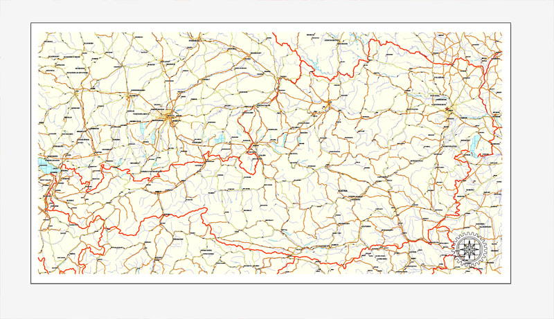
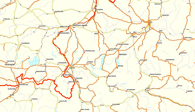
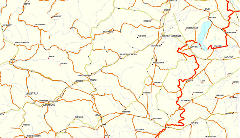
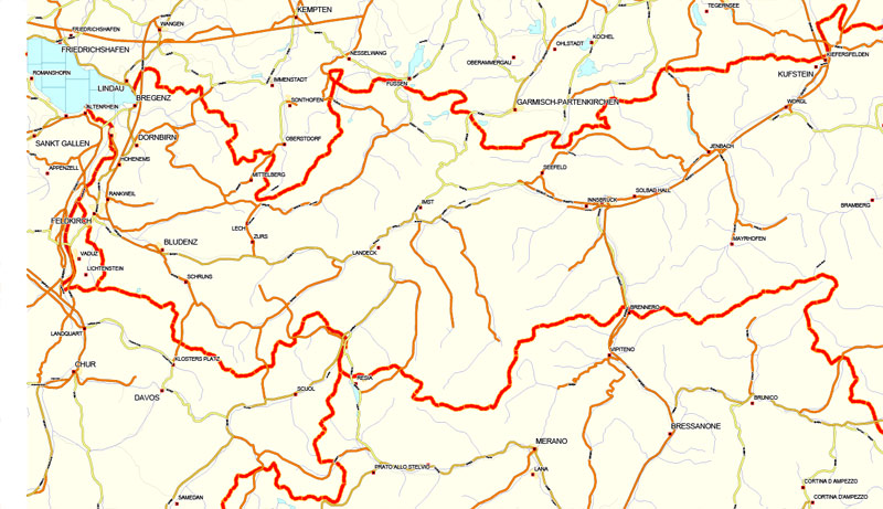
This Austria vector map features:
Highways, major roads
Big and small Rivers, small streams also,
Lake, ponds and other water bodies,
Landmark fill.
Need more data, or something special? Please, feel free to contact our friendly team.
Looking for more Austria vector maps?
Austria.
This vector map of Austria is used as a basis for design, editing, and further printing.
This is the most detailed, exact map of Austria for high-quality printing and polygraphy. You can always clarify the map development date by contacting us.
For your convenience, all objects on Austria vector map are divided into layers. And the editing is very easy – colors, lines, etc.
You can easily add any objects needed (e.g. shops, salons, sale points, gas station or attraction) on any layer of Austria vector map.
Austria is a country of nearly 9 million people in Central Europe. It is bordered by the Czech Republic and Germany to the north, Hungary and Slovakia to the east, Slovenia and Italy to the south, and Switzerland and Liechtenstein to the west. The territory of Austria covers 83,879 km2 (32,386 sq mi). The terrain is highly mountainous, lying within the Alps; only 32% of the country is below 500 m (1,640 ft), and its highest point is 3,798 m (12,461 ft). The majority of the population speaks local Bavarian dialects of German as their native language, and German in its standard form is the country’s official language. Other local official languages are Hungarian, Burgenland Croatian, and Slovene.
One of the advantages of Austria vector maps of our production is the relevance of cartographic data, we constantly update all our products.
This vector map of Austria is used by:
designers, layout designers, printers, advertisers and architects. Our product – vector maps – is designed for further editing and printing in large formats – from @Wall format (a few meters) to A-0 and A-1, A-2, A-3.
The Austria map in vector format is used for design, urban planning, presentations and media visualizations.
The advertising and presentation map of Austria (usually the final designer marks the routes, and puts the client’s objects (shops, saloons, gas stations etc.)
The undoubted advantage is that people will NEVER throw out this advertising product – the map. In fact, as an advertising medium, a map is the most “long-playing” of the well-known polygraphic advertising media, with the longest lifespan, and the maximum number of interactions with the customer.
For travelers, maps are sold at the airports and gas stations around the world. Often the source is our vector maps.
Take a look, who purchases our vector maps of Austria in “Our Clients and Friends” page – these are large and small companies, from super-brands like Volvo and Starbucks, to small design studios and printing houses.
It’s very easy to work with vector maps of Austria city, even for a not very experienced designer who can turn on and off the map layers, add new objects, change the colors of fill and lines according to customer requirements.
The undoubted advantage of Austria vector maps in printing is an excellent and detailed visualization, when customer can expand a large paper map and instantly define his location, find a landmark, an object or address on map, unlike using the popular electronic formats of Google and Yandex maps for example.
Printable vector maps of Austria are much more convenient and efficient than any electronic maps on your smartphone, because ALL DETAILS are displayed in the entire space of Austria map.
Useful tips on working with vector maps of cities and countries in Adobe Illustrator.
«V» – launches the Selection tool (cursor, black arrow), which makes active any vector line.
«А» – launches the Direct Selection tool (white cursor), allows you to select curve elements and drag them to the desired place.
«R» – activates the Rotate tool, which helps you rotating selected objects around the center point by 360 degrees.
«E» – gives you the opportunity to use the Eraser tool and erase unnecessary parts.
«X» – switches between Fill and Stroke in the Tools section. Try to get used to this hot key and
you will quickly understand that you can’t live and work without it.
Guides are not limited to vertical and horizontal in Adobe Illustrator. You can also create a diagonal guide for example. Moreover, you can turn any contours into guides. Select the outline and go to View > Guides > Make Guides (Create Guides), or simply press Cmd/Ctrl + 5. You can also turn the guides back into an editable object. Go to menu, View > Guides > Unlock Guides (Release Guides), select the guide you want to edit and select View > Guides > Release Guides (Reset Guides), or just press Cmd/Ctrl + Option / Alt + 5).
You will probably want to change the color scheme used on our Austria vector map.
To quickly and effectively play with colors.
Of course, you can do it manually, all objects in our Austria vector map are divided according to types and layers, and you can easily change the color gamma of vector objects in groups and layers.
But there is more effective way of working with the whole VECTOR MAP of Austria and all layers:
The overview dialog «Edit colors»/«Repaint Graphic Object» (this dialog box name can change depending on the context):
If you have selected a part or a layer of Austria vector map and open the dialog box by clicking the icon in the Control panel, on the Samples palette or the Color Catalog, or if you choose Edit > Edit Colors> Repaint Graphic Object, then the «Repaint Graphic Object» dialog box appears, and you get access to «Assign» and «Edit» tabs.
If a picture or a map fragment is not selected, and you open the dialog box by clicking the icon in the Control panel, on the Samples palette or in the Color Catalog, the «Edit Colors» dialog box appears and you can only access the «Edit» tab.
Regardless of the name at the top of the dialog box, the right-hand side always displays the color group of the current document, as well as two default color groups: Print Color and Grayscale. These color groups can be selected and used any time.
Create and edit color groups of Austria vector map, and also assign colors using the «Edit Colors»/ а «Repaint Graphic Object» dialog box.
A. Creating and editing of a color group on the «Edit» tab
B. Assigning colors on the «Assign» tab
C. Select a group of colors from the «Color groups» list
The option «Repaint a graphic object» in the lower part of the dialog box allows you to preview the colors on a selected layer of Vector map, or a group of elements, and specify whether its colors will be redefined when the dialog box is closed.
The main areas of the dialog box are:
«Edit»
The «Edit» tab is designed to create a new or edit the existing color groups.
The harmony rules Menu and the Color Wheel are used to conduct experiments with color harmonies. The color wheel shows how colors are related in color harmony, and the color bars allow you to view and manipulate an individual color values. In addition, you can adjust the brightness, add and remove colors, save color groups and view colors on the selected Vector Map of Austria or a separated layers.
«Assign»
The «Assign» tab is used to view and control on how the original colors are replaced with colors from the color group like your corporate colors in the Vector Map of Austria city.
The assign color ability is provided only if the entire map, layer or fragment is selected in the document. You can specify which of new colors replace the current colors, whether the spot colors should be preserved and how colors are replaced (for example, you can replace colors completely or changing the color tone while maintaining the brightness). The «Assign» tab allows you to redefine colors in the Vector Map of Austria city, or in separate layers and fragments using the current color group or reducing the number of colors in the current Vector Map.
Color groups
Is a list of all saved color groups for current document (the same groups appear in the «Samples» palette). You can edit and delete the existing color groups, as well as creating a new ones using the list of “Color Groups” in the dialog box. All changes appear in the «Samples» palette.
The highlighted color group shows, which color group is currently edited.
Any color group can be selected and edited, or used to redefine the colors in the selected vector map of Austria city, its fragments or elements.
Saving a color group adds this group to the specified list.
Opening the «Edit Colors»/«Repaint Graphic Object» dialog box.
Open the «Edit Colors»/«Repaint Graphic Object» dialog box using one of the following methods:
«Edit»> «Edit Colors»> «Repaint Graphic object» or «Repaint With Style».
Use these commands if you need to edit the colors in the selected vector map of Austria city.
«Repaint Graphic object» button on the «Control» panel.
Use this button if you need to adjust colors of Austria vector map using the а «Repaint graphic object» dialog box.
The specified button is available if the selected vector map or its fragment contains two or more colors.
Note. This color editing method is convenient for global color adjustment in a vector map, if global colors were not used when creating a Map of Austria.
The «Edit colors» button or «Edit or apply colors» on the «Color Catalog» palette
Click this button if you need to edit colors on the «Color Catalog» palette or edit and then apply them to the selected Vector Map of Austria or its fragment.
The «Edit color group» button or «Edit or apply color group» on the «Samples» palette.
Click this button if you need to edit the colors in the specific color group or edit and apply them to the selected Vector Map of Austria or a group of its elements, for example, the whole layer “Streets and lines”. You can also double-click the color group in the Samples panel to open the dialog box.
If the map file is too large and your computer freezes or even can’t open it quickly:
1. Try to reduce the color resolution of the video card (display) to 256 colors while working with a large map.
2. Using Windows Task Manager, select all the application you don’t need, while working with map, just turn them off.
3. Launch Adobe Illustrator. (DO NOT OPEN the vector map file)
4. Start the Windows Task Manager using administrator rights > Find the “Illustrator” process > set the «real time» priority,
5. Open the file. When you see the LEGACY FONT popup window – click “OK” (do not update). You can restore the TEXT later.
6. Can also be useful: When file is opened – Edit > Settings > Basic Settings > disable smoothing. /// It looks scary, but works quickly)))
We recommend saving the file in Adobe Illustrator 10 version. It’s much more stable when working with VERY BIG size files.
Austria is a federal republic with a parliamentary representative democracy comprising nine federated states. The capital and largest city, with a population exceeding 1.8 million, is Vienna. Other major urban areas of Austria include Graz, Linz, Salzburg and Innsbruck. Austria is consistently ranked as one of the richest countries in the world by per capita GDP terms. The country has developed a high standard of living and in 2018 was ranked 20th in the world for its Human Development Index. The republic declared its perpetual neutrality in foreign political affairs in 1955. Austria has been a member of the United Nations since 1955, joined the European Union in 1995, and is a founder of the OECD. Austria also signed the Schengen Agreement in 1995, and adopted the euro currency in 1999.
Geography
Austria is a largely mountainous country due to its location in the Alps. The Central Eastern Alps, Northern Limestone Alps and Southern Limestone Alps are all partly in Austria. Of the total area of Austria (84,000 km2 or 32,433 sq mi), only about a quarter can be considered low lying, and only 32% of the country is below 500 metres (1,640 ft). The Alps of western Austria give way somewhat into low lands and plains in the eastern part of the country.
Austria lies between latitudes 46° and 49° N, and longitudes 9° and 18° E.
It can be divided into five areas, the biggest being the Eastern Alps, which constitute 62% of the nation’s total area. The Austrian foothills at the base of the Alps and the Carpathians account for around 12% and the foothills in the east and areas surrounding the periphery of the Pannoni low country amount to about 12% of the total landmass. The second greater mountain area (much lower than the Alps) is situated in the north. Known as the Austrian granite plateau, it is located in the central area of the Bohemian Mass and accounts for 10% of Austria. The Austrian portion of the Vienna basin comprises the remaining 4%.
Austria is a small, predominantly mountainous country in Central Europe, approximately between Germany, Italy and Hungary. It has a total area of 83,879 km² (32,385 mi²), about twice the size of Switzerland.
The landlocked country shares national borders with Switzerland (a non-European Union member state, which it borders for 158 km, or 98 mi) and the principality of Liechtenstein (also a non-EU member state, of which it borders for 34 km or 21 mi) to the west, Germany (801 km or 497 mi) and the Czech Republic (402 km or 249 mi) and Slovakia (105 km or 65 mi) to the north, Hungary to the east (331 km or 205 mi), and Slovenia (299 km or 185 mi) and Italy (404 km or 251 mi) to the south (total: 2,534 km or 1,574 mi).
The westernmost third of the somewhat pear-shaped country consists of a narrow corridor between Germany and Italy that is between 32 km (19 mi) and 60 km (37 mi) wide. The rest of Austria lies to the east and has a maximum north–south width of 280 km (173 mi). The country measures almost 600 km (372 mi) in length, extending from Lake Constance (German Bodensee) on the Austrian-Swiss-German border in the west to the Neusiedler See on the Austrian-Hungarian border in the east. The contrast between these two lakes – one in the Alps and the other a typical steppe lake on the westernmost fringe of the Hungarian Plain – illustrates the diversity of Austria’s landscape.
Seven of Austria’s nine provinces have long historical traditions predating the establishment of the Republic of Austria in 1918: Upper Austria, Lower Austria, Styria, Carinthia, Salzburg, Tyrol, and Vorarlberg. The provinces of Burgenland and Vienna were established after World War I. Most of Burgenland had been part of the Kingdom of Hungary, but it had a predominantly German-speaking population and hence became Austrian. Administrative and ideological reasons played a role in the establishment of Vienna as an independent province. Vienna, historically the capital of Lower Austria, was a socialist stronghold, whereas Lower Austria was conservative, and both socialists and conservatives wanted to consolidate their influence in their respective provinces. Each province has a provincial capital with the exception of Vienna, which is a province in its own right in addition to being the federal capital. In Vienna, the City Council and the mayor function as a provincial parliament and provincial governor, respectively.
Purchasing and downloading of Corel Draw Austria (Europe) vectorial map
We accept PayPal and Credit Card payment. After the payment you will be redirected to the download page. We guarantee 100% satisfaction. Royalty Free license.
De:
Über diese vectorial Karte von Österreich (Europa) in (.CDR) Format
Archivgröße: 2.1 Mb, Reißverschluss .CDR
DPI: 300
Vektor-Karte Daten: 2016
Lizenz: Royalty Free
Österreich Vektorkarten in Corel Draw Format [.CDR] sind voll editierbar Karten, die in allen Größen benötigt werden, egal was groß es ist gedruckt werden kann. Ohne Qualitätsverlust, weil es `s Vektor-Format.
Alle Karten im Vektorkarte-Portal hat eine Royalty Free Lizenz. Sie don `t für jeden Einsatz zu bezahlen, können Sie alle Inhalte, die Sie möchten, einschließlich Linienstärke, Schriftdesign zu ändern, oder fügen Sie die Objekte, die Sie wollen.
Wir bieten Ihnen eine sehr genaue Karten von Österreich, ideal für Großformatdruck, wie Bürowänden oder Werbetafeln.
Auch in andere Formate zum gleichen Preis: DWG, DXF AutoCAD, AI, EPS, PDF.
Das Österreich-Vektor-Karte verfügt über:
Autobahnen, Hauptstraßen
Große und kleine Flüsse, kleine Bäche auch,
See, Teichen und anderen Gewässern,
Landmark Füllung.
Sie benötigen weitere Daten oder etwas Besonderes? Bitte, zögern Sie unser freundliches Team zu kontaktieren.
Städte und Landkreise in der Nähe oder in Österreich vectorial Karte, Europa
Auf der Suche nach mehr Österreich Vektorkarten?
Kaufen und Herunterladen von Corel Draw Österreich (Europa) vectorial Karte
Wir akzeptieren PayPal und Kreditkarten-Zahlung. Nach der Bezahlung werden Sie zur Download-Seite umgeleitet werden. Wir garantieren 100% Zufriedenheit. Lizenzfreie Lizenz.

 Author: Kirill Shrayber, Ph.D. FRGS


