Extended Description of the Vector Map
Printable PDF Vector Map Austria Full high detailed road map + admin 1, 2 areas + cities and towns and villages + water objects editable Layered Adobe PDF, + separate file (same scale) all roads, scalable, editable text format of all names, 622 Mb ZIP.
Layered exact editable map: Map for publishing, design, printing, publications, arts, projects, presentations, for architects, designers, and builders, business, logistics. The most exact and detailed map. GPS correct Mercator Projection.
For printing any format.
Please note: This country map is compiled from multiple, unrelated geodata sources.
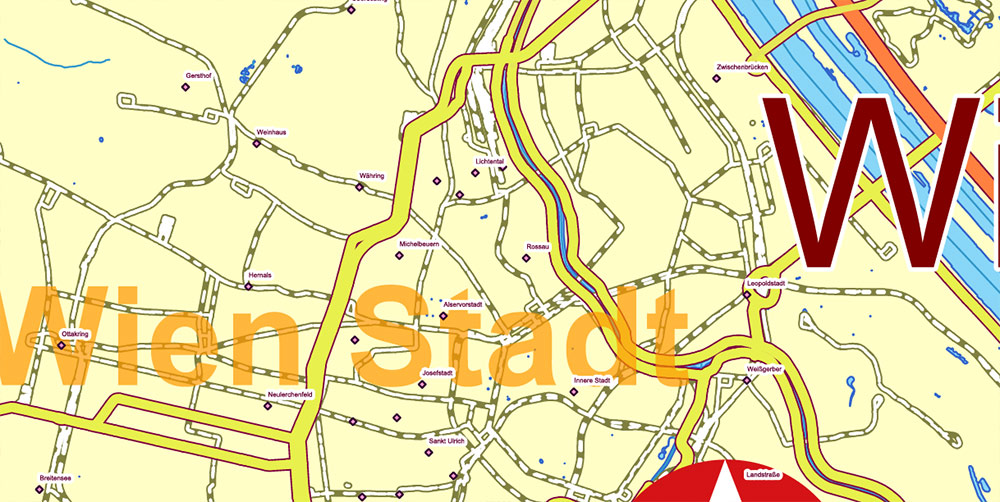
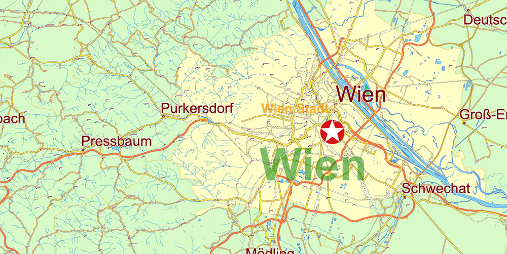
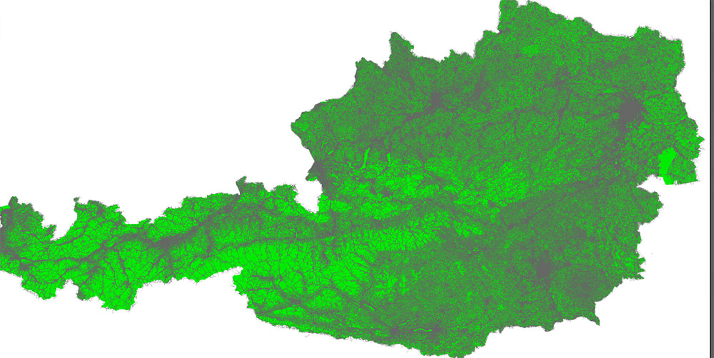
Please note: in the preview, ALL LAYERS are enabled and visible. Of course, you can easily turn off the layers you don’t need and the map will become much simpler.
DWG, DXF, CDR, ESRI Shapes, and other formats – by request, the same price, please contact.
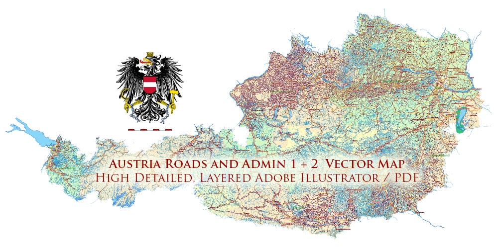
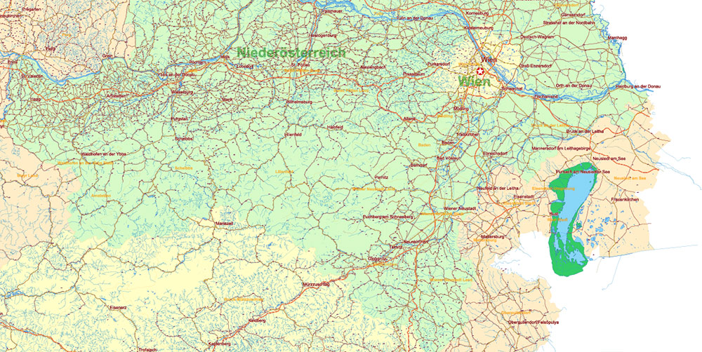
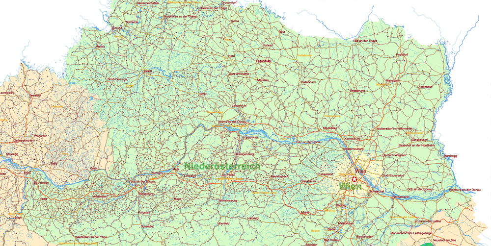
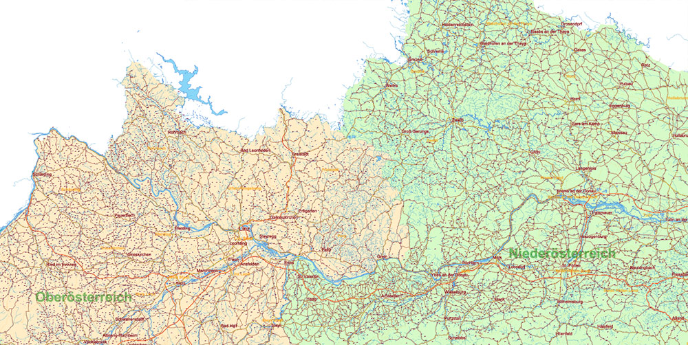
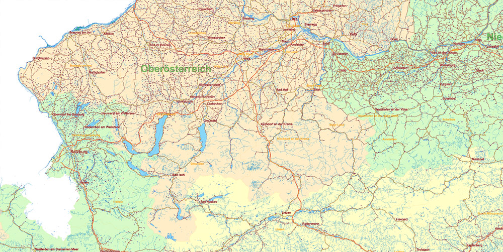
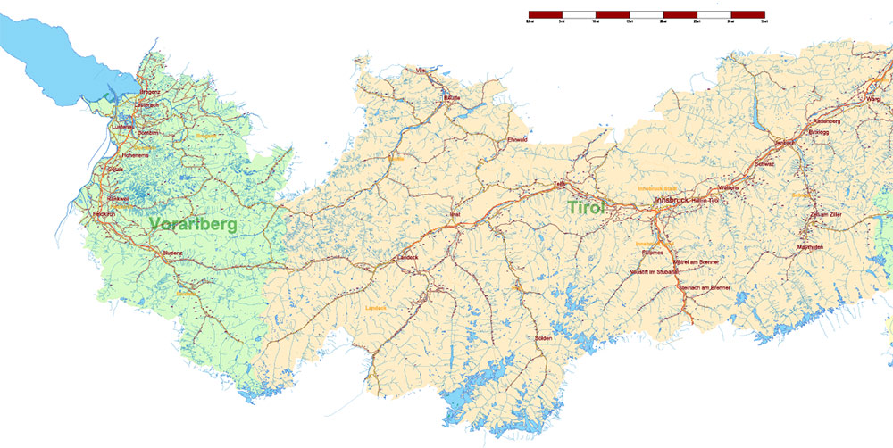
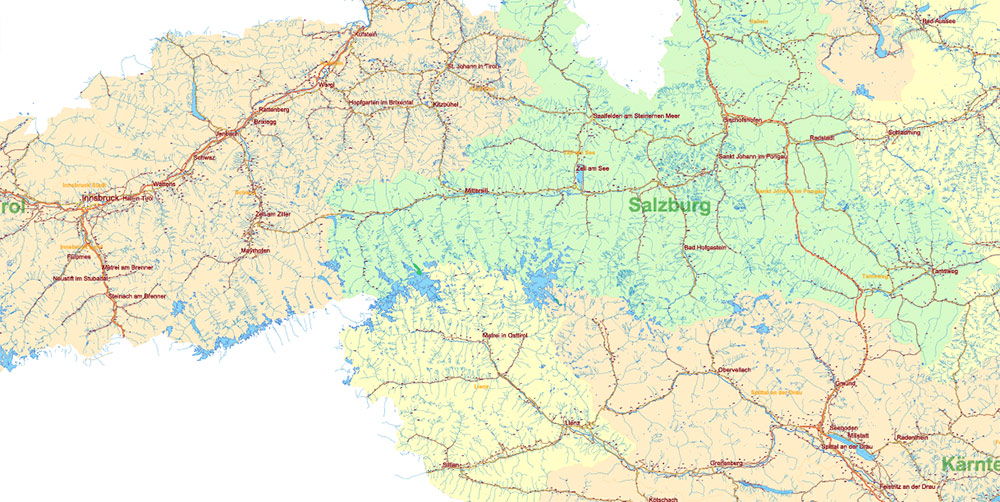
Austria Full PDF Vector Map high detailed all road map + admin 1, 2 areas + cities, towns and water objects editable Layered Adobe PDF
Separated layers:
- Legend / Scale
- Names main cities and towns
- Names villages
- Geopoints 1, 2 – cities, towns, villages
- Names admin areas 2 Politische Bezirke
- Names admin areas 1 Bundesländer
- Main roads and streets
- Railroads
- All streets and roads (separated file, same scale)
- Waterways
- Water areas
- Admin areas 2 Politische Bezirke
- Admin areas 1 Bundesländer
- Background
Austria Full PDF Vector Map high detailed all road map + admin 1, 2 areas + cities, towns and water objects editable Layered Adobe PDF
Austria Full PDF Vector Map high detailed all road map + admin 1, 2 areas + cities, towns and water objects editable Layered Adobe PDF
Austria Full PDF Vector Map high detailed all road map + admin 1, 2 areas + cities, towns and water objects editable Layered Adobe PDF
AO BRIEF: Austria Operational Overview
Overview / Ground Truth
-
Landlocked Central Europe; borders DE, CZ, SK, HU, SI, IT, CH, LI.
-
Core axes: Danube corridor east–west, Alpine valleys north–south.
-
Population: ~9.1M; highly urbanized east (Vienna) with dispersed Alpine communities elsewhere.
-
Terrain: ~60% Alpine; remaining lowlands/basins in the east and north.
Administrative Divisions (9 Bundesländer)
-
Vienna (Wien) – city-state, national hub.
-
Lower Austria (Niederösterreich) – encircles Vienna; agriculture/industry.
-
Upper Austria (Oberösterreich) – Linz industrial belt, Danube crossings.
-
Styria (Steiermark) – Graz; forested uplands.
-
Salzburg – Alpine passes and tunnels.
-
Tyrol (Tirol) – split by East Tyrol; controls Brenner and Inn Valley.
-
Carinthia (Kärnten) – lakes/Alpine basins; links to Slovenia/Italy.
-
Vorarlberg – western wedge to Switzerland/Liechtenstein; Lake Constance.
-
Burgenland – flatlands to Hungary; Lake Neusiedl.
Key Rivers & Lakes (Hydrography)
-
Rivers (operational corridors & flood risks):
-
Danube (Donau): Vienna–Linz–Passau axis; main inland waterway.
-
Inn: Tyrol to Germany via the Inn Valley (Inntal).
-
Enns, Salzach, Traun: Danube tributaries; valley mobility.
-
Mur (Graz) & Drava/Drau (Carinthia): SE corridors toward Slovenia/Croatia.
-
Major lakes (visibility/weather modifiers, local choke lines):
-
Neusiedler See (Burgenland), Attersee/Traunsee/Wolfgangsee/Mondsee (Salzkammergut),
Wörthersee (Carinthia), Millstätter See (Carinthia), Bodensee/Lake Constance (Vorarlberg).
Relief & Mobility (Terrain)
-
Alps dominate: steep relief, narrow valleys, high avalanche/rockfall risk.
-
Primary passes/tunnels (critical choke points):
-
Brenner (A13/A22, rail): Tyrol ↔ Italy; busiest north–south Alpine crossing.
-
Tauern (A10, Tauern/Katschberg tunnels): Salzburg ↔ Carinthia.
-
Arlberg (S16, road/rail tunnels): Tyrol ↔ Vorarlberg.
-
Semmering (S6, historic rail tunnel + S6 expressway): Lower Austria ↔ Styria.
-
Pyhrn (A9, Bosruck/Pyhrn tunnels): Upper Austria ↔ Styria.
-
Karawanken (A11 tunnel): Carinthia ↔ Slovenia.
Climate / Seasonality
Main Cities (Urban Terrain)
-
Vienna (Wien): capital; dense historic core + ring roads; Danube channels/islands; major bridges and port.
-
Graz: Mur River; mixed historic/modern fabric; university city.
-
Linz: Danube industrial hub; bridge chokepoints.
-
Salzburg: river constriction between hills; tourism density.
-
Innsbruck: tight Inn Valley corridor; gateway to Brenner.
-
Klagenfurt/Villach (Carinthia): nodes near Wörthersee and Tauern/Karawanken axes.
-
Bregenz/Dornbirn (Vorarlberg): Lake Constance rim; access to CH/DE.
Demography / Human Terrain
-
Language: German (standard); recognized minority communities (Slovene in Carinthia, Croatian/Hungarian in east).
-
Population density: highest in Vienna Basin and Danube corridor; sparse high-alpine settlements.
-
Socio-economic: high infrastructure reliability, strong civil services, tourism-heavy Alpine regions.
Transportation Network (LOCs)
Road (Autobahnen & Schnellstraßen):
-
A1 West (Vienna–St. Pölten–Linz–Salzburg): primary E–W spine.
-
A2 Süd (Vienna–Graz–Klagenfurt–Italy/Slovenia): SE axis.
-
A3 (to Burgenland/Hungary), A4 Ost (Vienna–Airport–Hungary).
-
A8 Innkreis (Upper Austria ↔ Germany).
-
A9 Pyhrn (Linz–Graz via tunnels).
-
A10 Tauern (Salzburg–Carinthia via Tauern/Katschberg).
-
A11 Karawanken (to Slovenia), A12 Inntal (German border–Innsbruck),
-
A13 Brenner (Innsbruck–Italy), A14 Rheintal/Walgau (Vorarlberg).
-
S6 Semmering, S16 Arlberg (key tunnel routes).
Rail (ÖBB):
-
Westbahn (Vienna–Linz–Salzburg–Innsbruck–Bregenz): high-capacity corridor.
-
Südbahn (Vienna–Graz–Villach): links to Italy/Slovenia.
-
Tauern/Arlberg/Semmering lines: tunnel-dependent, weather-resilient but chokepoint-sensitive.
Airports (fixed-wing insertion/logistics):
-
Vienna (VIE) primary international hub. Regional fields: Salzburg (SZG), Innsbruck (INN), Graz (GRZ), Linz (LNZ), Klagenfurt (KLU), smaller airfields throughout Alpine valleys (weather-limited).
Inland Waterway:
Hazards / Threats to Movement
-
Alpine hazards: avalanches, rockfall, white-outs; winter tire/chain mandates.
-
Hydro: Danube/tributary floods; bridge closures = major detours.
-
Tunnels: incident in a long tunnel (Arlberg/Tauern/Karawanken) can sever regions.
-
Fog: persistent in Vienna/Linz/Graz basins autumn–winter.
Logistics / Sustainment Notes
-
Best ground MSRs: A1 (E–W), A2/A9 (SE), A12–A13 (Brenner N–S), A10 (central N–S).
-
Rail redundancy via multiple long tunnels; still corridor-dependent.
-
Fuel/depots concentrated along Autobahnen and around Vienna/Linz/Graz nodes.
-
Medical/urban support strongest in Vienna, Graz, Linz, Innsbruck, Salzburg.
Command Takeaways
-
Two natural axes: Danube (E–W) and Alpine valleys/passes (N–S); control bridges and tunnels to shape maneuver.
-
Winter dominates planning: allocate de-icing, avalanche intel, alternate routes; pre-clear tunnel risks.
-
Urban chokepoints: Vienna bridges, Linz crossings, Innsbruck valley constriction, Salzburg river gap.
-
Interoperability: quick cross-border pivots via Brenner (IT), Karawanken (SI), and Danube ports (DE/SK/HU).
-
Redundancy: pair road MSRs with rail equivalents; pre-stage at basin edges for weather windows.
Austria Full PDF Vector Map high detailed all road map + admin 1, 2 areas + cities, towns and water objects editable Layered Adobe PDF
Austria Full PDF Vector Map high detailed all road map + admin 1, 2 areas + cities, towns and water objects editable Layered Adobe PDF
Austria Full PDF Vector Map high detailed all road map + admin 1, 2 areas + cities, towns and water objects editable Layered Adobe PDF
Austria Full PDF Vector Map high detailed all road map + admin 1, 2 areas + cities, towns and water objects editable Layered Adobe PDF

Austria Full PDF Vector Map high detailed all road map + admin 1, 2 areas + cities, towns and water objects editable Layered Adobe PDF
Austria Full PDF Vector Map high detailed all road map + admin 1, 2 areas + cities, towns and water objects editable Layered Adobe PDF
Austria Full PDF Vector Map high detailed all road map + admin 1, 2 areas + cities, towns and water objects editable Layered Adobe PDF
Austria Full PDF Vector Map high detailed all road map + admin 1, 2 areas + cities, towns and water objects editable Layered Adobe PDF


 Author: Kirill Shrayber, Ph.D. FRGS


