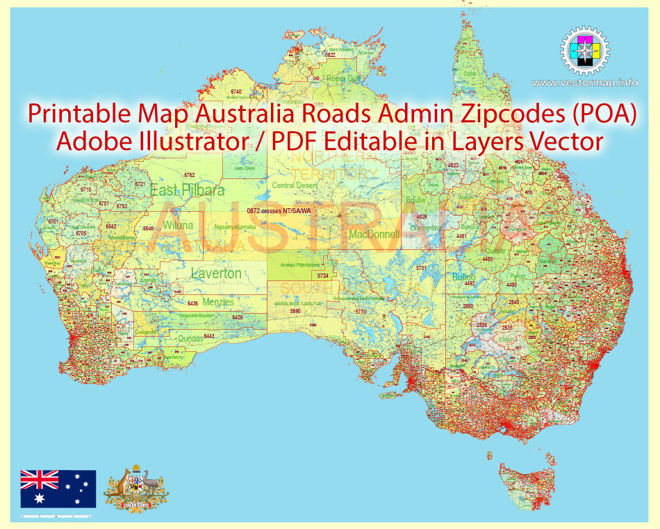
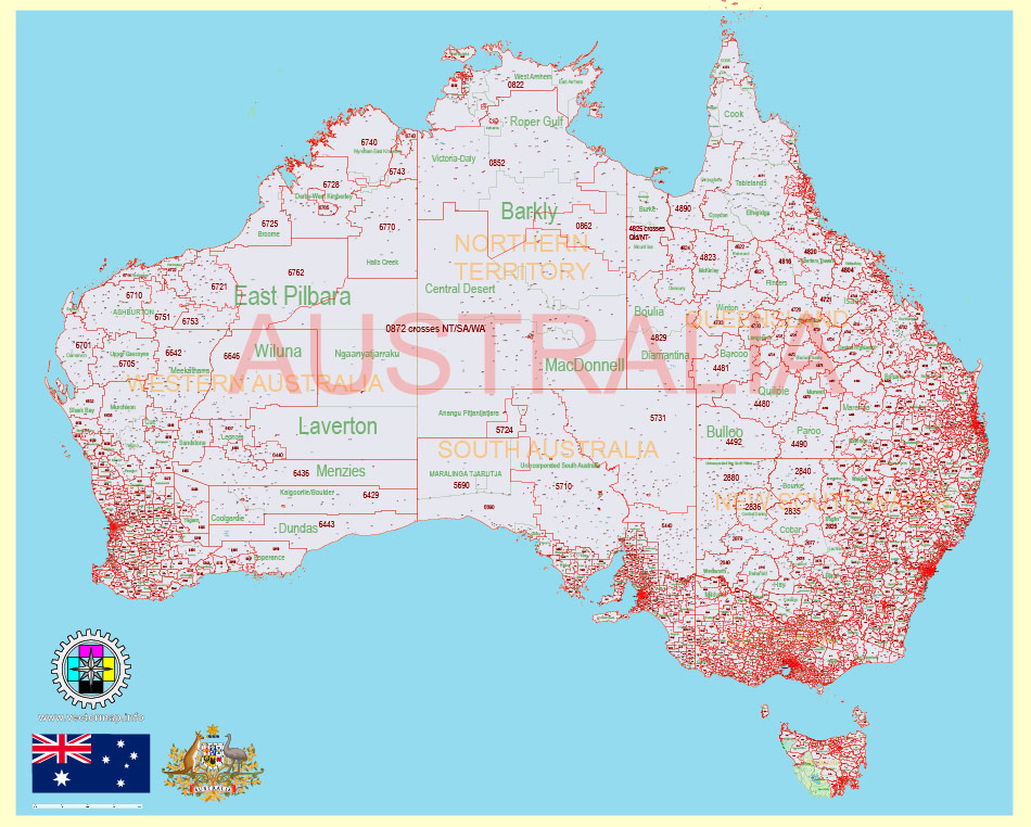
Printable Vector PDF Map Australia, exact extra detailed Country Plan Roads Admin ZipCodes (POA) full editable Adobe PDF in layers, scalable, 200 mb ZIP
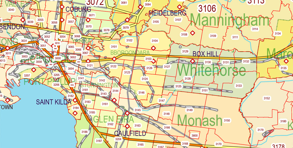
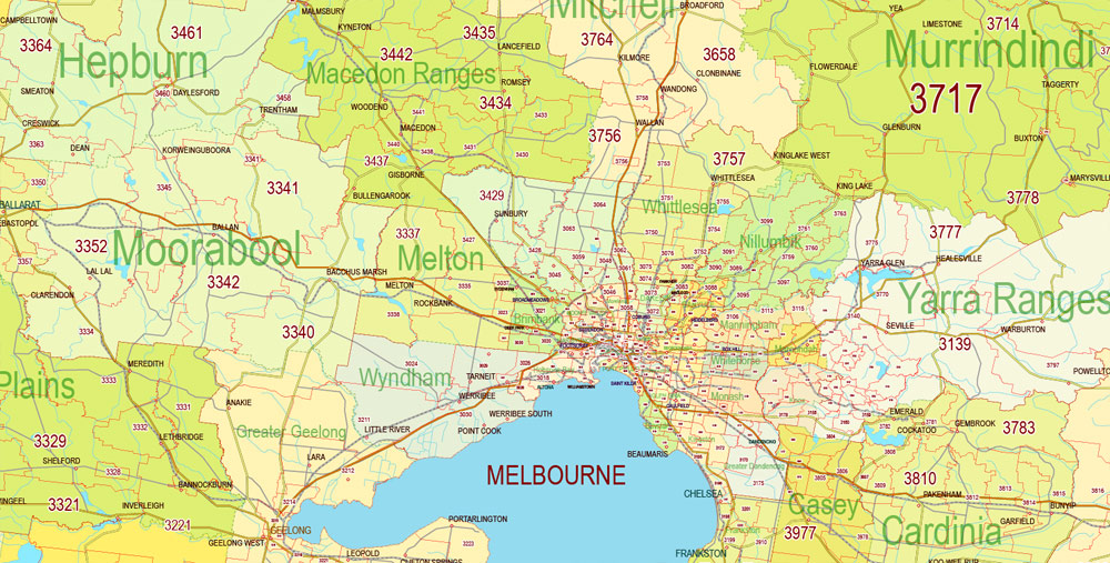
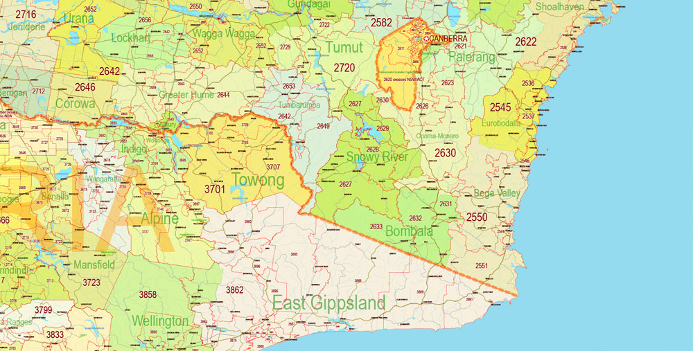
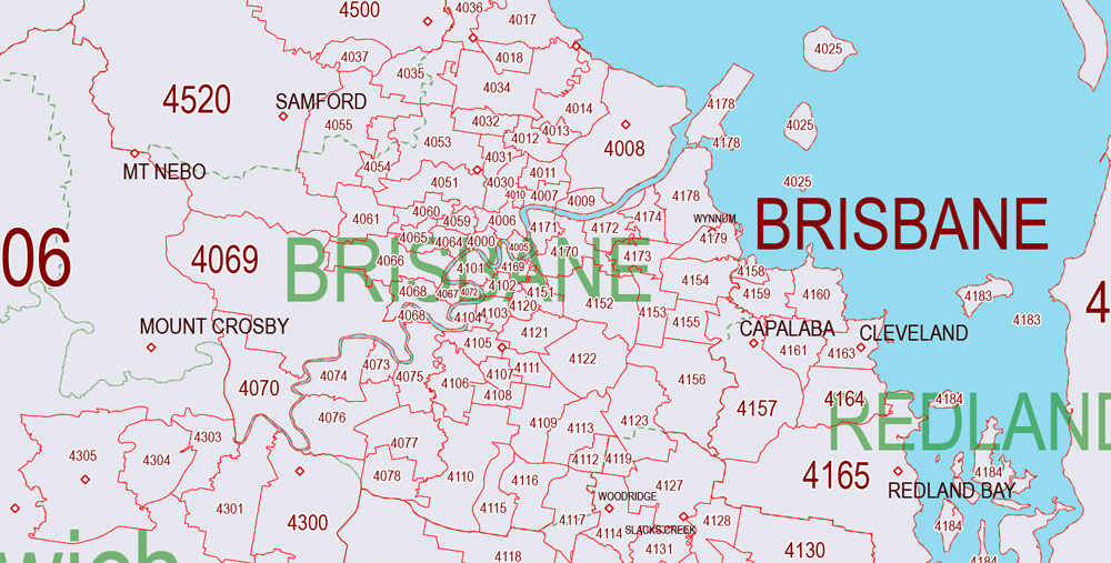
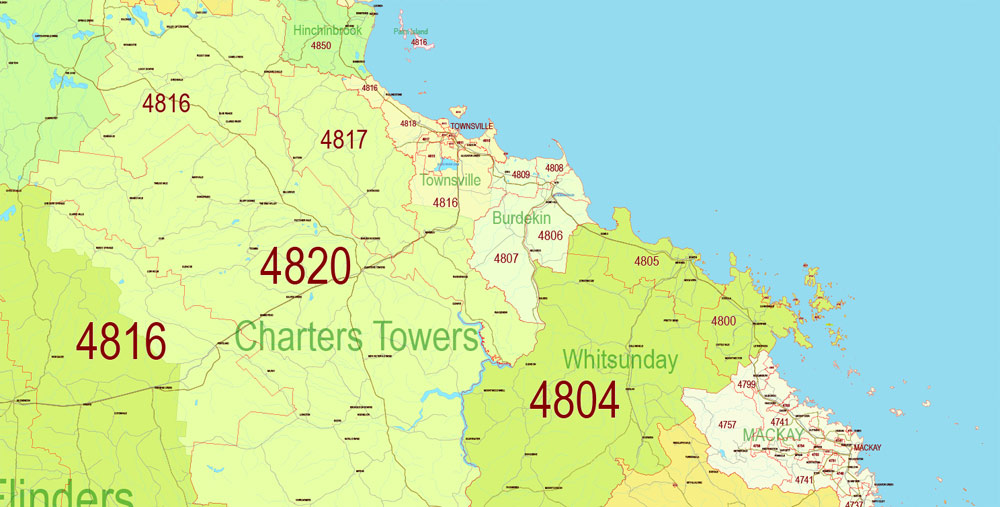
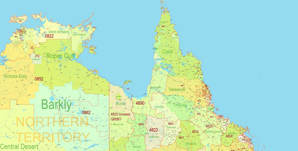
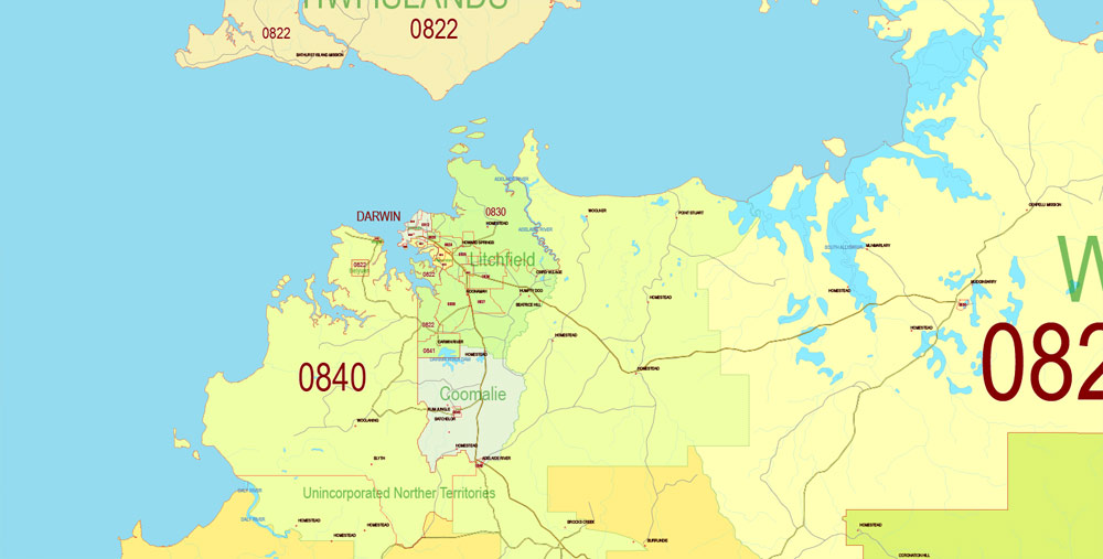
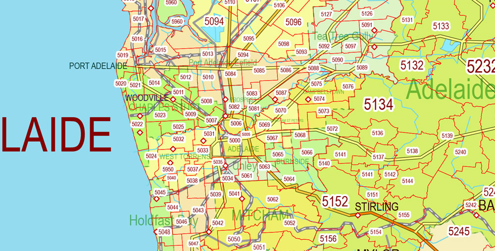
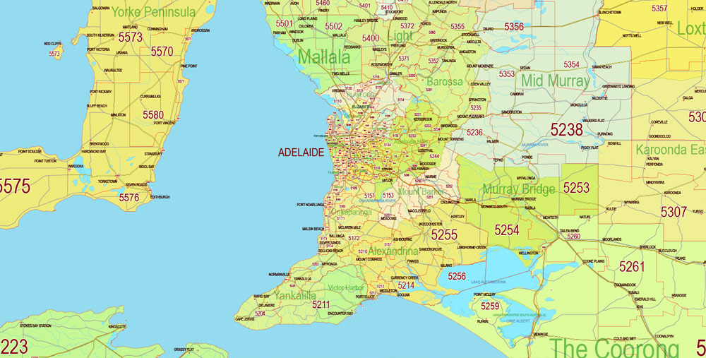
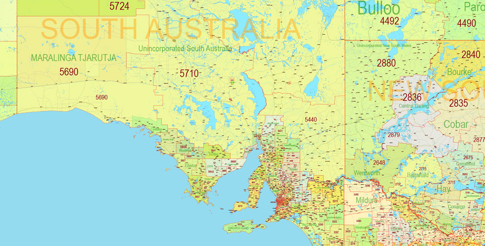
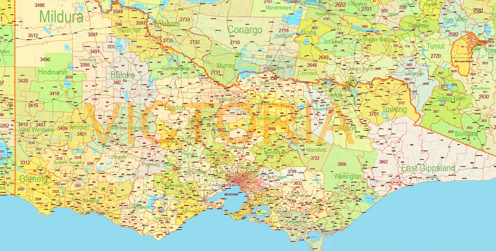
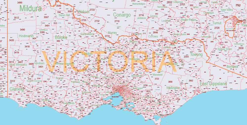
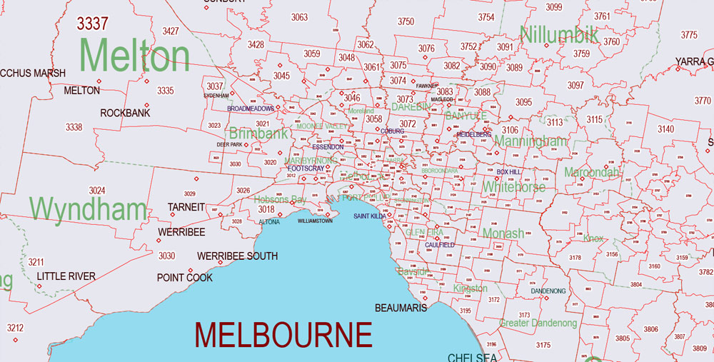
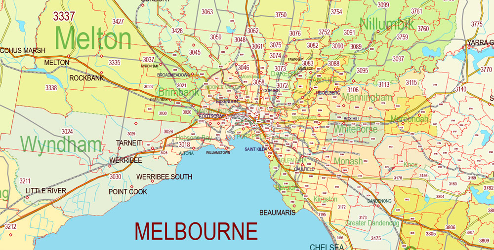
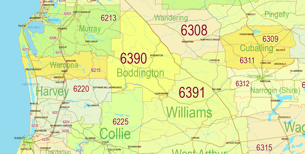
Main roads, cities, admin areas, ZIPcodes (POA). Map for design, printing, arts, projects, presentations, for architects, designers and builders, business, logistics.
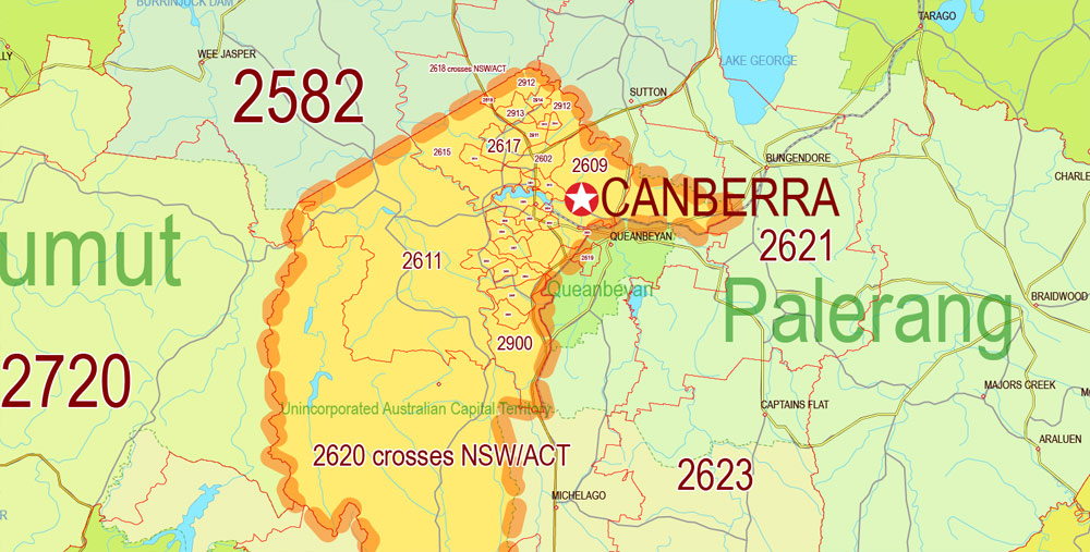
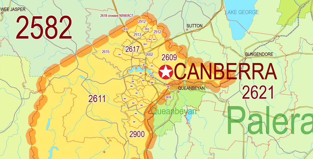
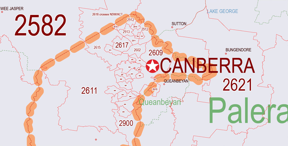
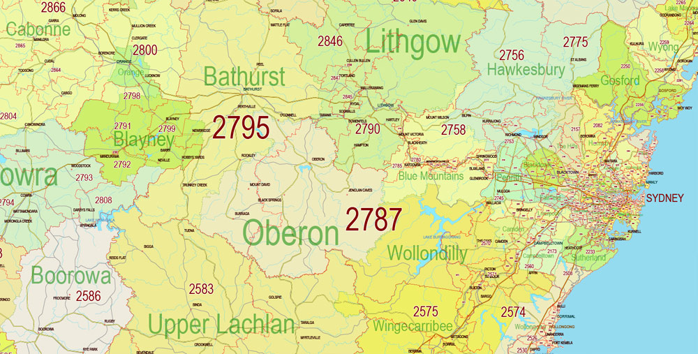
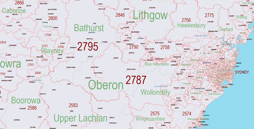
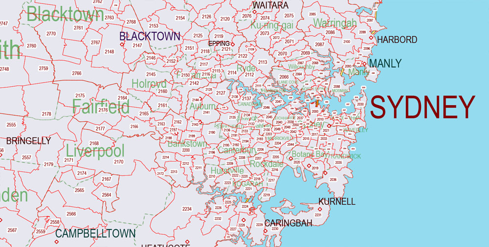
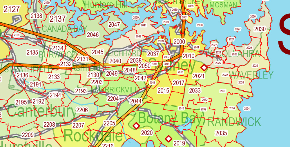
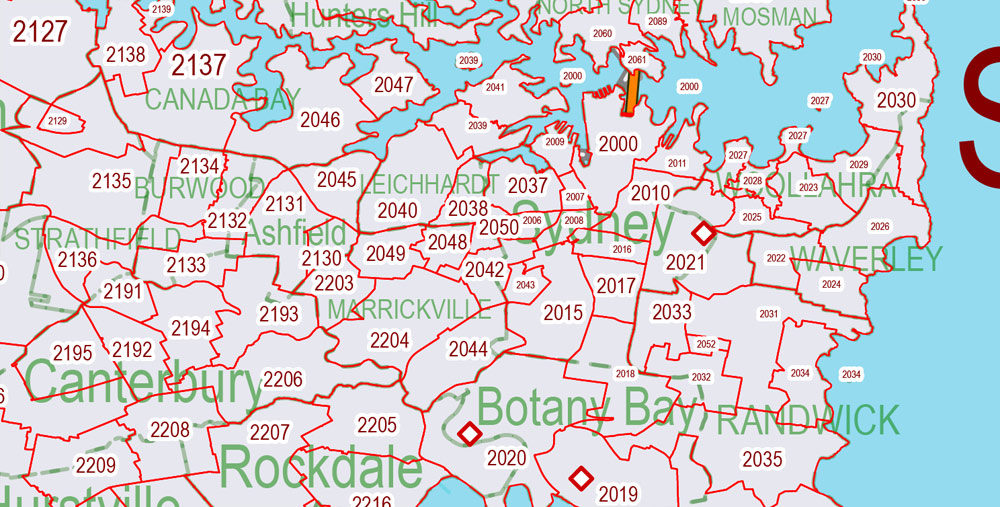
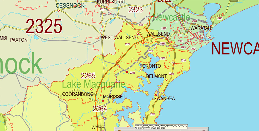
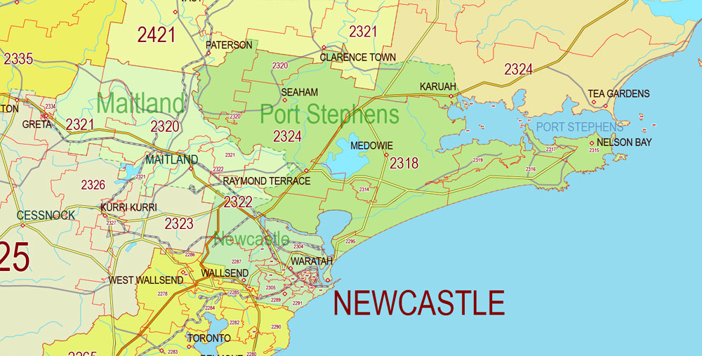
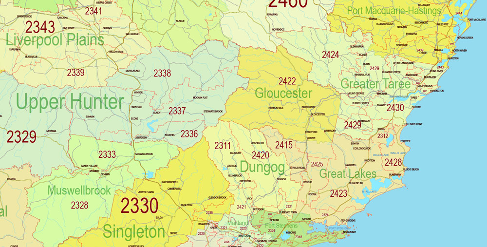
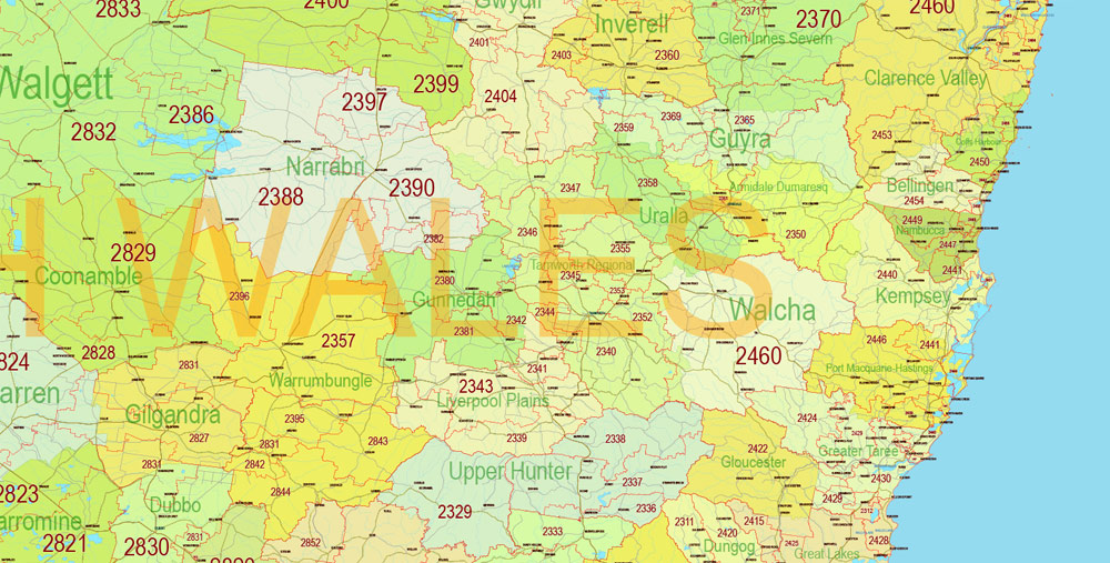
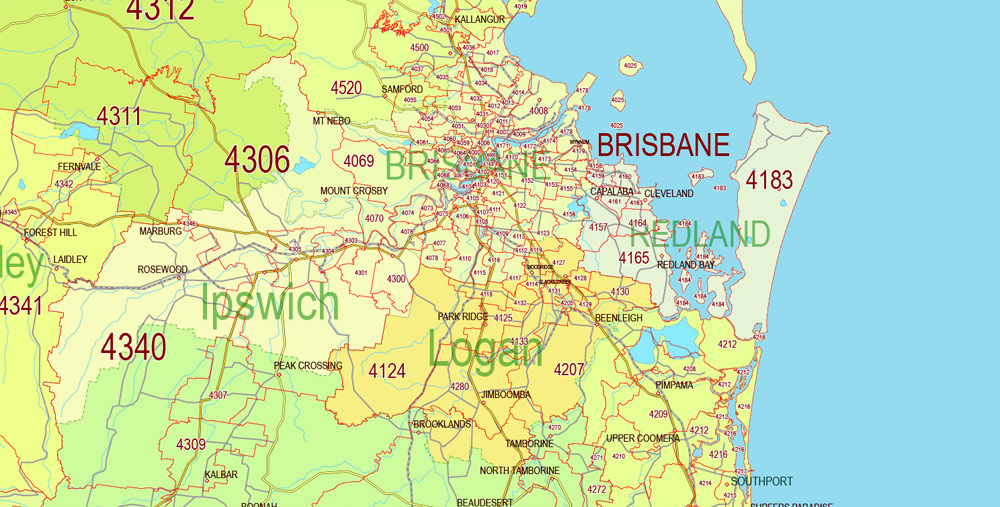
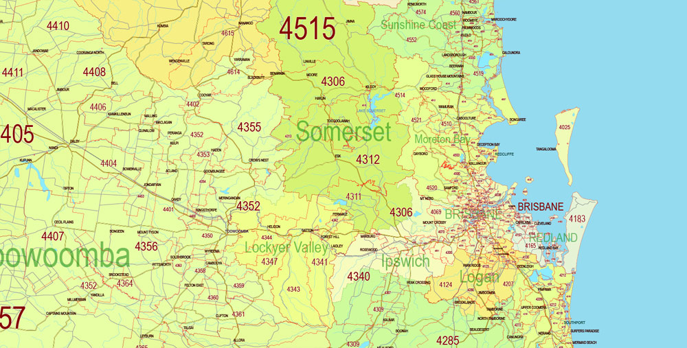
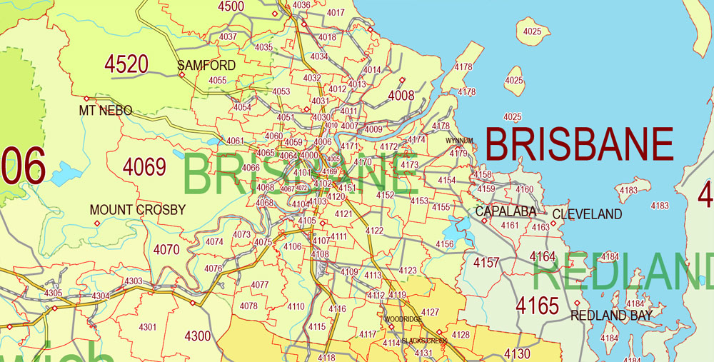
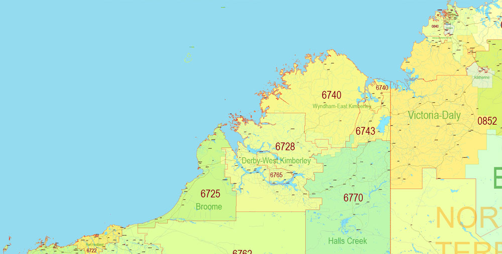
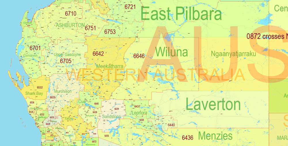
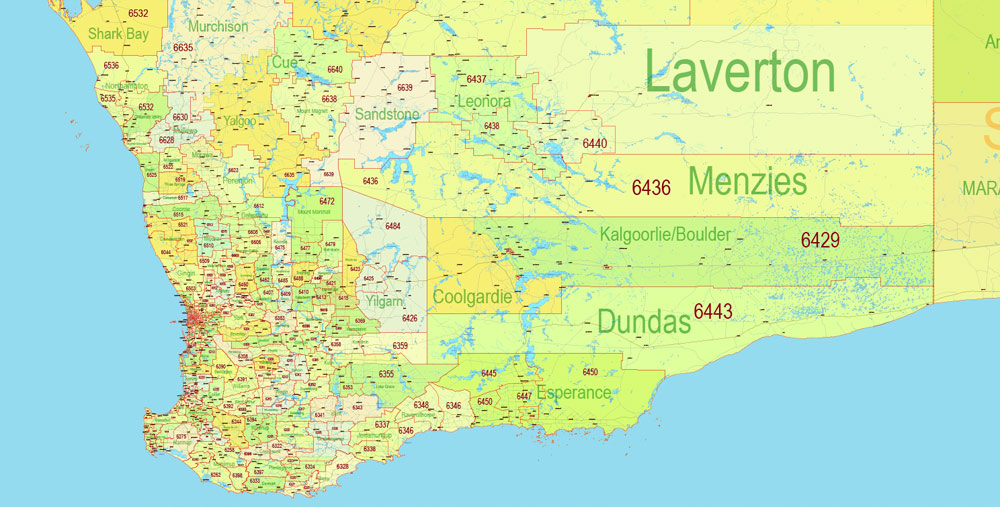
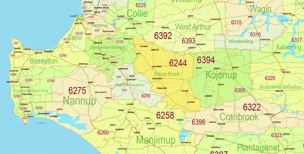
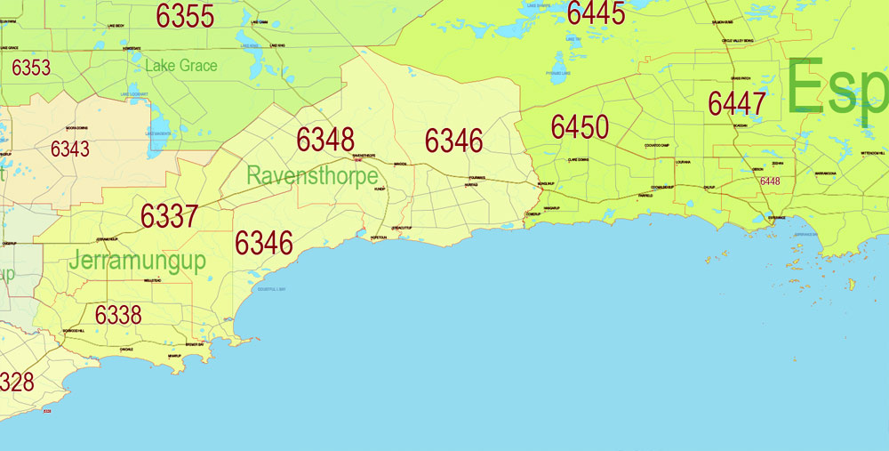
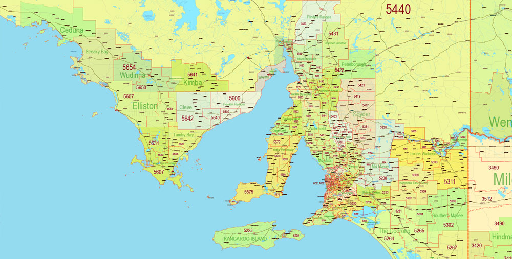
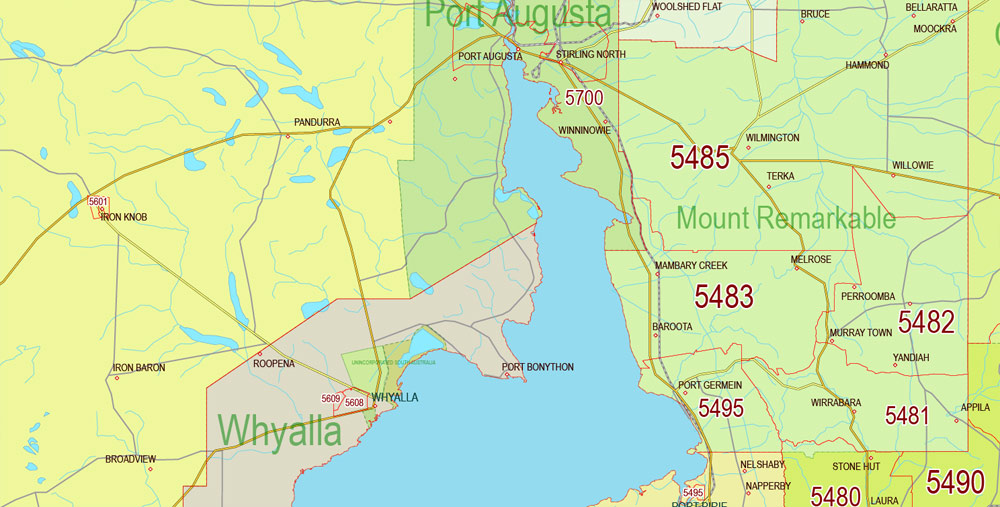
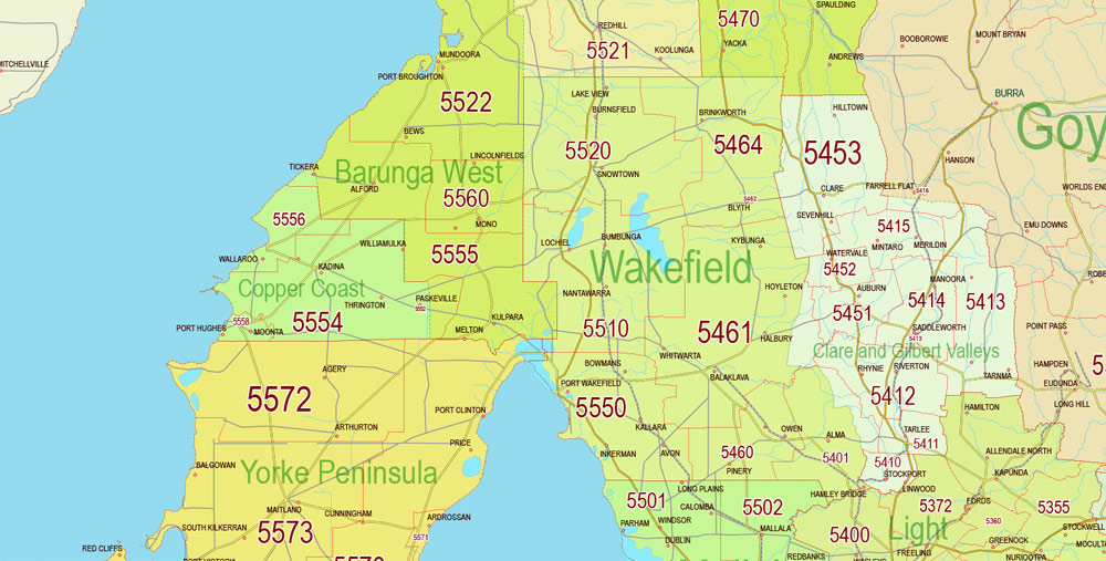
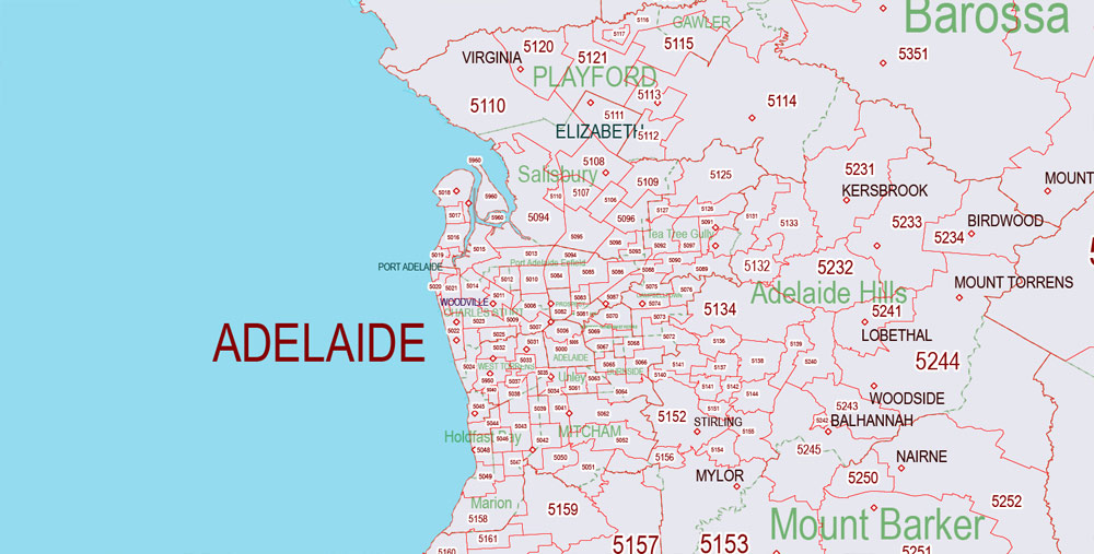
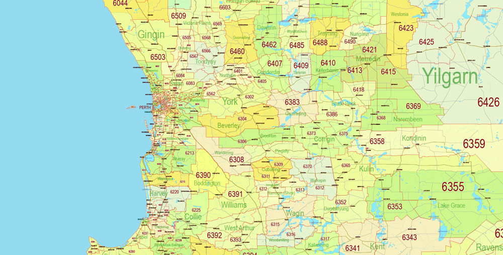
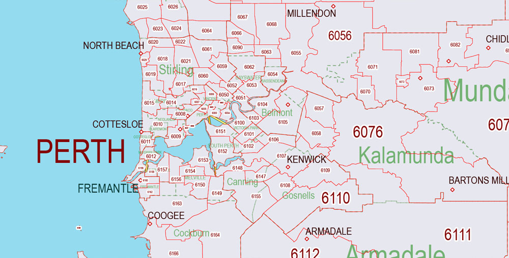
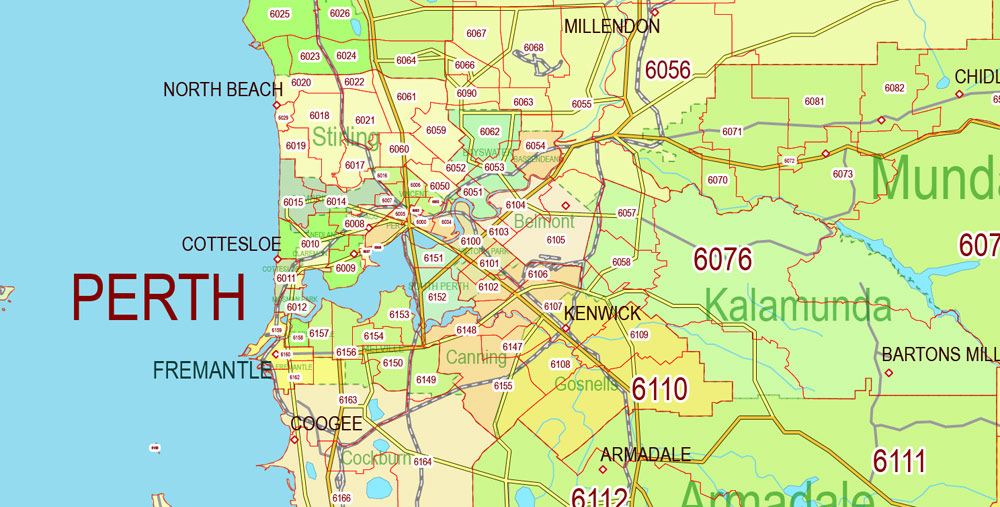
Layers: Back, Sea, Land, States, Admin_Areas_fills, Borders_Admin_Areas, Admin_Areas_names, Water_objects, Names_States, RailRoads, ZipCodes_Areas_Polygons , Numbers_ZipCodes (POA), Halo_Numbers_ZipCodes, Main_roads, Civil_roads, Dots_Cities, Names_Cities.
The most exact and detailed map of Australia.
For High Quality Printing.
Australia.
This vector map of Australia is used as a basis for design, editing, and further printing.
This is the most detailed, exact map of Australia for high-quality printing and polygraphy. You can always clarify the map development date by contacting us.
For your convenience, all objects on Australia vector map are divided into layers. And the editing is very easy – colors, lines, etc.
You can easily add any objects needed (e.g. shops, salons, sale points, gas station or attraction) on any layer of Australia vector map.
Australia is a sovereign country comprising the mainland of the Australian continent, the island of Tasmania and numerous smaller islands. It is the largest country in Oceania and the world’s sixth-largest country by total area. The neighbouring countries are Papua New Guinea, Indonesia and East Timor to the north; the Solomon Islands and Vanuatu to the north-east; and New Zealand to the south-east. The population of 25 million is highly urbanised and heavily concentrated on the eastern seaboard. Australia’s capital is Canberra, and its largest city is Sydney.
One of the advantages of Australia vector maps of our production is the relevance of cartographic data, we constantly update all our products.
This vector map of Australia is used by:
designers, layout designers, printers, advertisers and architects. Our product – vector maps – is designed for further editing and printing in large formats – from @Wall format (a few meters) to A-0 and A-1, A-2, A-3.
The Australia map in vector format is used for design, urban planning, presentations and media visualizations.
The advertising and presentation map of Australia (usually the final designer marks the routes, and puts the client’s objects (shops, saloons, gas stations etc.)
The undoubted advantage is that people will NEVER throw out this advertising product – the map. In fact, as an advertising medium, a map is the most “long-playing” of the well-known polygraphic advertising media, with the longest lifespan, and the maximum number of interactions with the customer.
For travelers, maps are sold at the airports and gas stations around the world. Often the source is our vector maps.
Take a look, who purchases our vector maps of Australia in “Our Clients and Friends” page – these are large and small companies, from super-brands like Volvo and Starbucks, to small design studios and printing houses.
It’s very easy to work with vector maps of Australia city, even for a not very experienced designer who can turn on and off the map layers, add new objects, change the colors of fill and lines according to customer requirements.
The undoubted advantage of Australia vector maps in printing is an excellent and detailed visualization, when customer can expand a large paper map and instantly define his location, find a landmark, an object or address on map, unlike using the popular electronic formats of Google and Yandex maps for example.
The country’s other major metropolitan areas are Melbourne, Brisbane, Perth and Adelaide.
Australia was inhabited by indigenous Australians for about 60,000 years before the first British settlement in the late 18th century. It is documented that Aborigines spoke languages that can be classified into about 250 groups. After the European exploration of the continent by Dutch explorers in 1606, who named it New Holland, Australia’s eastern half was claimed by Great Britain in 1770 and initially settled through penal transportation to the colony of New South Wales from 26 January 1788, a date which became Australia’s national day.
Printable vector maps of Australia are much more convenient and efficient than any electronic maps on your smartphone, because ALL DETAILS are displayed in the entire space of Australia map.
Useful tips on working with vector maps of cities and countries in Adobe Illustrator.
«V» – launches the Selection tool (cursor, black arrow), which makes active any vector line.
«А» – launches the Direct Selection tool (white cursor), allows you to select curve elements and drag them to the desired place.
«R» – activates the Rotate tool, which helps you rotating selected objects around the center point by 360 degrees.
«E» – gives you the opportunity to use the Eraser tool and erase unnecessary parts.
«X» – switches between Fill and Stroke in the Tools section. Try to get used to this hot key and
you will quickly understand that you can’t live and work without it.
Guides are not limited to vertical and horizontal in Adobe Illustrator. You can also create a diagonal guide for example. Moreover, you can turn any contours into guides. Select the outline and go to View > Guides > Make Guides (Create Guides), or simply press Cmd/Ctrl + 5. You can also turn the guides back into an editable object. Go to menu, View > Guides > Unlock Guides (Release Guides), select the guide you want to edit and select View > Guides > Release Guides (Reset Guides), or just press Cmd/Ctrl + Option / Alt + 5).
You will probably want to change the color scheme used on our Australia vector map.
To quickly and effectively play with colors.
Of course, you can do it manually, all objects in our Australia vector map are divided according to types and layers, and you can easily change the color gamma of vector objects in groups and layers.
But there is more effective way of working with the whole VECTOR MAP of Australia and all layers:
The overview dialog «Edit colors»/«Repaint Graphic Object» (this dialog box name can change depending on the context):
If you have selected a part or a layer of Australia vector map and open the dialog box by clicking the icon in the Control panel, on the Samples palette or the Color Catalog, or if you choose Edit > Edit Colors> Repaint Graphic Object, then the «Repaint Graphic Object» dialog box appears, and you get access to «Assign» and «Edit» tabs.
If a picture or a map fragment is not selected, and you open the dialog box by clicking the icon in the Control panel, on the Samples palette or in the Color Catalog, the «Edit Colors» dialog box appears and you can only access the «Edit» tab.
The population grew steadily in subsequent decades, and by the 1850s most of the continent had been explored and an additional five self-governing crown colonies established. On 1 January 1901, the six colonies federated, forming the Commonwealth of Australia. Australia has since maintained a stable liberal democratic political system that functions as a federal parliamentary constitutional monarchy comprising six states and ten territories.
Regardless of the name at the top of the dialog box, the right-hand side always displays the color group of the current document, as well as two default color groups: Print Color and Grayscale. These color groups can be selected and used any time.
Being the oldest, flattest and driest inhabited continent, with the least fertile soils, Australia has a landmass of 7,617,930 square kilometres (2,941,300 sq mi). A megadiverse country, its size gives it a wide variety of landscapes, with deserts in the centre, tropical rainforests in the north-east and mountain ranges in the south-east. A gold rush began in Australia in the early 1850s, which boosted the population of the country. Nevertheless, its population density, 2.8 inhabitants per square kilometre, remains among the lowest in the world. Australia generates its income from various sources including mining-related exports, telecommunications, banking and manufacturing. Indigenous Australian rock art is the oldest and richest in the world, dating as far back as 60,000 years and spread across hundreds of thousands of sites.
Create and edit color groups of Australia vector map, and also assign colors using the «Edit Colors»/ а «Repaint Graphic Object» dialog box.
A. Creating and editing of a color group on the «Edit» tab
B. Assigning colors on the «Assign» tab
C. Select a group of colors from the «Color groups» list
The option «Repaint a graphic object» in the lower part of the dialog box allows you to preview the colors on a selected layer of Vector map, or a group of elements, and specify whether its colors will be redefined when the dialog box is closed.
Australia is a highly developed country, with the world’s 13th-largest economy. It has a high-income economy, with the world’s tenth-highest per capita income. Australia is a regional power and has the world’s 13th-highest military expenditure.
The main areas of the dialog box are:
«Edit»
The «Edit» tab is designed to create a new or edit the existing color groups.
The harmony rules Menu and the Color Wheel are used to conduct experiments with color harmonies. The color wheel shows how colors are related in color harmony, and the color bars allow you to view and manipulate an individual color values. In addition, you can adjust the brightness, add and remove colors, save color groups and view colors on the selected Vector Map of Australia or a separated layers.
«Assign»
The «Assign» tab is used to view and control on how the original colors are replaced with colors from the color group like your corporate colors in the Vector Map of Australia city.
The assign color ability is provided only if the entire map, layer or fragment is selected in the document. You can specify which of new colors replace the current colors, whether the spot colors should be preserved and how colors are replaced (for example, you can replace colors completely or changing the color tone while maintaining the brightness). The «Assign» tab allows you to redefine colors in the Vector Map of Australia city, or in separate layers and fragments using the current color group or reducing the number of colors in the current Vector Map.
Australia has the world’s 9th largest immigrant population with immigrants accounting for 26% of the population. Having the third-highest human development index and the eighth-highest ranked democracy globally, the country ranks highly in quality of life, health, education, economic freedom, civil liberties and political rights, with all its major cities faring well in global comparative livability surveys. Australia is a member of the United Nations, G20, Commonwealth of Nations, ANZUS, Organisation for Economic Co-operation and Development (OECD), World Trade Organization, Asia-Pacific Economic Cooperation, Pacific Islands Forum and the ASEAN Plus Six mechanism.
Color groups
Is a list of all saved color groups for current document (the same groups appear in the «Samples» palette). You can edit and delete the existing color groups, as well as creating a new ones using the list of “Color Groups” in the dialog box. All changes appear in the «Samples» palette.
The highlighted color group shows, which color group is currently edited.
Any color group can be selected and edited, or used to redefine the colors in the selected vector map of Australia city, its fragments or elements.
Saving a color group adds this group to the specified list.
Opening the «Edit Colors»/«Repaint Graphic Object» dialog box.
Open the «Edit Colors»/«Repaint Graphic Object» dialog box using one of the following methods:
«Edit»> «Edit Colors»> «Repaint Graphic object» or «Repaint With Style».
Geography of Australia
The geography of Australia encompasses a wide variety of biogeographic regions being the world’s smallest continent but the sixth-largest country in the world. The population of Australia is concentrated along the eastern and southeastern coasts. The geography of the country is extremely diverse, ranging from the snow-capped mountains of the Australian Alps and Tasmania to large deserts, tropical and temperate forests.
Use these commands if you need to edit the colors in the selected vector map of Australia city.
«Repaint Graphic object» button on the «Control» panel.
Use this button if you need to adjust colors of Australia vector map using the а «Repaint graphic object» dialog box.
The specified button is available if the selected vector map or its fragment contains two or more colors.
Note. This color editing method is convenient for global color adjustment in a vector map, if global colors were not used when creating a Map of Australia.
Neighbouring countries include Indonesia, East Timor and Papua New Guinea to the north, the Solomon Islands, Vanuatu and the French dependency of New Caledonia to the east, and New Zealand to the southeast.
The «Edit colors» button or «Edit or apply colors» on the «Color Catalog» palette
Click this button if you need to edit colors on the «Color Catalog» palette or edit and then apply them to the selected Vector Map of Australia or its fragment.
The «Edit color group» button or «Edit or apply color group» on the «Samples» palette.
Click this button if you need to edit the colors in the specific color group or edit and apply them to the selected Vector Map of Australia or a group of its elements, for example, the whole layer “Streets and lines”. You can also double-click the color group in the Samples panel to open the dialog box.
Physical geography
Australia is a country, a continent and an island. It is located in Oceania between the Indian Ocean and the South Pacific Ocean. It is the sixth largest country in the world with a total area of 7,686,850 square kilometres (2,967,910 sq mi) (including Lord Howe Island and Macquarie Island), making it slightly smaller than the 48 states of the contiguous United States and 31.5 times larger than the United Kingdom.

If the map file is too large and your computer freezes or even can’t open it quickly:
1. Try to reduce the color resolution of the video card (display) to 256 colors while working with a large map.
2. Using Windows Task Manager, select all the application you don’t need, while working with map, just turn them off.
3. Launch Adobe Illustrator. (DO NOT OPEN the vector map file)
4. Start the Windows Task Manager using administrator rights > Find the “Illustrator” process > set the «real time» priority,
5. Open the file. When you see the LEGACY FONT popup window – click “OK” (do not update). You can restore the TEXT later.
6. Can also be useful: When file is opened – Edit > Settings > Basic Settings > disable smoothing. /// It looks scary, but works quickly)))
We recommend saving the file in Adobe Illustrator 10 version. It’s much more stable when working with VERY BIG size files.
The Australian mainland has a total coastline length of 35,877 km (22,293 mi) with an additional 23,859 km (14,825 mi) of island coastlines. There are 758 estuaries around the country with most located in the tropical and sub-tropical zones. Australia claims an extensive Exclusive Economic Zone of 8,148,250 square kilometres (3,146,057 sq. mi). This exclusive economic zone does not include the Australian Antarctic Territory (an additional 5,896 square kilometres).
Australia has the largest area of ocean jurisdiction of any country on earth. It has no land borders. The northernmost points of the country are the Cape York Peninsula of Queensland and the Top End of the Northern Territory. The western half of Australia consists of the Western Plateau, which rises to mountain heights near the west coast and falls to lower elevations near the continental centre.
The Western Plateau region is generally flat, though broken by various mountain ranges such as the Hamersley Range, the MacDonnell Ranges, and the Musgrave Range. Surface water is generally lacking in the Western Plateau, although there are several larger rivers in the west and north, such as the Murchison, Ashburton, and Victoria river.
The Eastern Highlands, or Great Dividing Range, lie near the eastern coast of Australia, separating the relatively narrow eastern coastal plain from the rest of the continent. These Eastern Australian temperate forests have the greatest relief, the most rainfall, the most abundant and varied flora and fauna, and the densest human settlement.
Between the Eastern Highlands and the Western Plateau, lie the Central Lowlands, which are made up of the Great Artesian Basin and Australia’s largest river systems, Murray-Darling Basin and Lake Eyre Basin.
Off the eastern coast of Australia is the world’s largest coral reef complex, the Great Barrier Reef. The State of Tasmania, a large and mountainous island, resides in the south-eastern corner of Australia.
Regions
The Australian continental landmass consists of six distinct landform divisions. These are:
The Eastern Highlands—including the Great Dividing Range, the fertile Brigalow Belt strip of grassland behind the east coast, and the Eastern Uplands
The Eastern alluvial Plains and Lowlands—the Murray Darling basin covers the southern part; also includes parts of the Lake Eyre Basin and extends to the Gulf of Carpentaria
The South Australian Highlands—including the Flinders Range, Eyre Peninsula, and Yorke Peninsula
The Western Plateau—including the Nullarbor Plain
The Central Deserts
Northern Plateau and Basins—including the Top End
Australia
Australia officially the Commonwealth of Australia, is a sovereign country comprising the mainland of the Australian continent, the island of Tasmania and numerous smaller islands. It is the largest country in Oceania and the world’s sixth-largest country by total area. The neighbouring countries are Papua New Guinea, Indonesia and East Timor to the north; the Solomon Islands and Vanuatu to the north-east; and New Zealand to the south-east. Australia’s capital is Canberra, and its largest city is Sydney.
For about 60,000 years before the first British settlement in the late 18th century, Australia was inhabited by indigenous Australians, who in documented times have spoken languages classifiable into roughly 250 groups. After the European discovery of the continent by Dutch explorers in 1606, Australia’s eastern half was claimed by Great Britain in 1770 and initially settled through penal transportation to the colony of New South Wales from 26 January 1788. The population grew steadily in subsequent decades, and by the 1850s most of the continent had been explored and an additional five self-governing crown colonies established. On 1 January 1901, the six colonies federated, forming the Commonwealth of Australia. Australia has since maintained a stable liberal democratic political system that functions as a federal parliamentary constitutional monarchy comprising six states and several territories.
Australia has the world’s 13th-largest economy and tenth-highest per capita income. With the second-highest human development index globally, the country ranks highly in quality of life, health, education, economic freedom, and civil liberties and political rights. Australia is a member of the ASEAN Plus mechanism, United Nations, G20, Commonwealth of Nations, ANZUS, Organisation for Economic Co-operation and Development (OECD), World Trade Organization, Asia-Pacific Economic Cooperation, and the Pacific Islands Forum. The population of 25 million is highly urbanised and heavily concentrated on the eastern seaboard. Australia has the world’s 9th largest immigrant population, with immigrants accounting for 26% of the population.
Area
• Total 7,692,024 km2 (2,969,907 sq mi)
• Water (%) 0.76
Population
• 2018 estimate 24,942,400
• 2016 census 23,401,892
• Density 3.2/km2 (8.3/sq mi)
 full editable Adobe Illustrator")

 Author: Kirill Shrayber, Ph.D. FRGS

 Forests National Parks fully editable Adobe Illustrator")
 full editable Adobe Illustrator")