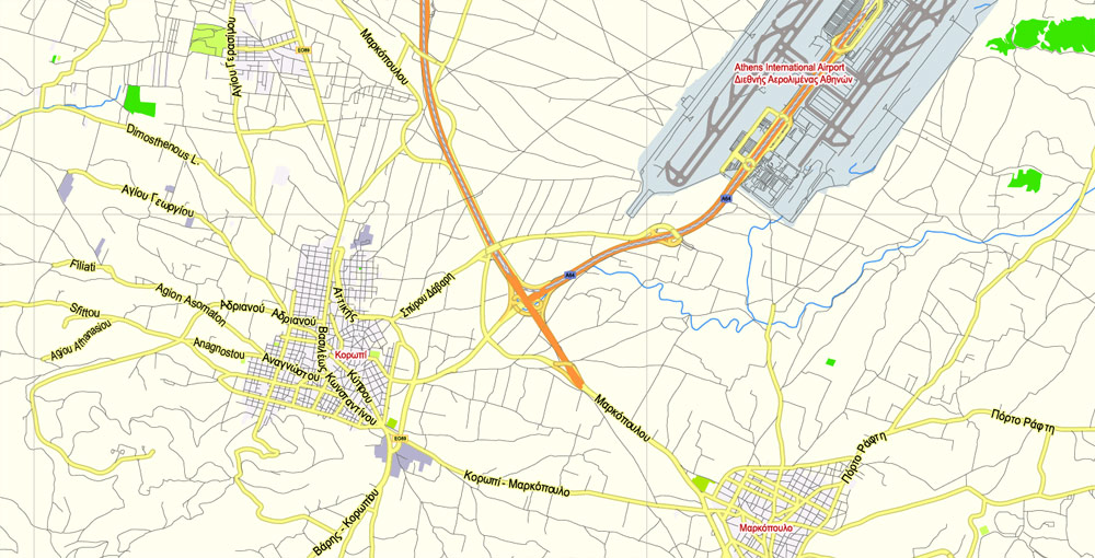
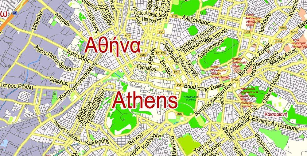
Printable CDR Vector Map Athens + Pireas, Greece, exact City Plan 2000 meters scale Street Map, Greek, fully editable, CorelDRAW, scalable, editable text format all names, 12 Mb ZIP.
Principal streets named, main objects. Map for publishing, design, printing, publications, arts, projects, presentations, for architects, designers, and builders, business, logistics. The most exact and detailed map of the city.
For High-Quality printing
Separated layers: streets and roads, color fills, road labels, names 1,2,3, grids, legend. Greek Names.
DWG, DXF, ESRI Shapes, and other formats – by request, the same price, please contact.
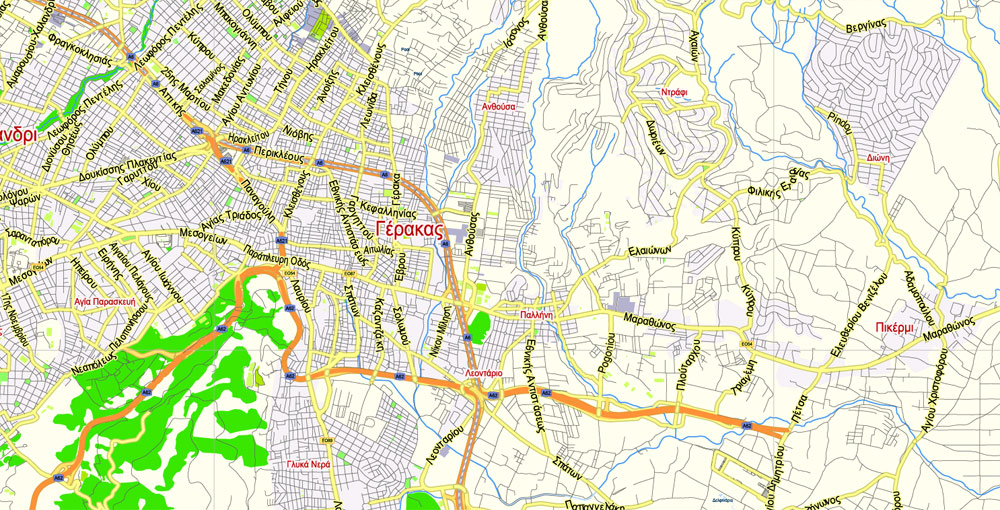
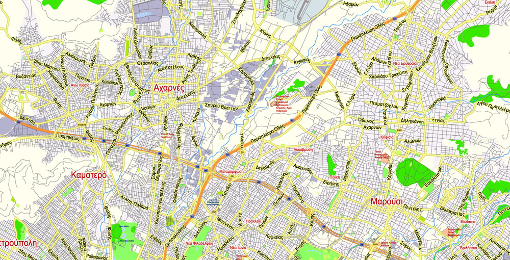
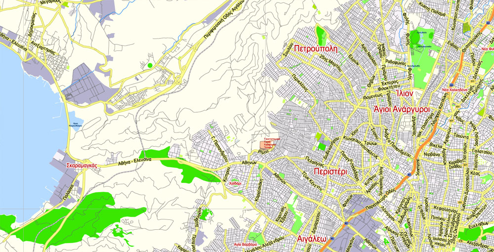
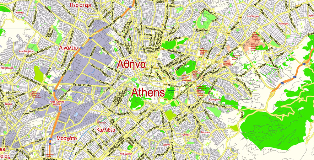
Athens and Piraeus, Greece.
This vector map of Athens city is used as a basis for design, editing, and further printing.
This is the most detailed, exact map of Athens city for high-quality printing and polygraphy. You can always clarify the map development date by contacting us.
For your convenience, all objects on Athens vector city map are divided into layers. And the editing is very easy – colors, lines, etc.
You can easily add any objects needed (e.g. shops, salons, sale points, gas station or attraction) on any layer of Athens vector map.
Athens is the capital and largest city of Greece. Athens dominates the Attica region and is one of the world’s oldest cities, with its recorded history spanning over 3,400 years and its earliest human presence starting somewhere between the 11th and 7th millennium BC.
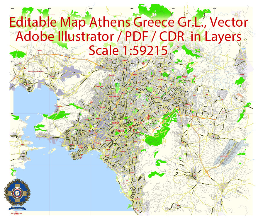
Athens + Pireas Printable CDR Vector Map, Greece, exact City Plan, 2000 meters scale Street Map Greek names fully editable CorelDRAW
One of the advantages of Athens city vector maps of our production is the relevance of cartographic data, we constantly update all our products.
This vector map of Athens city is used by:
designers, layout designers, printers, advertisers and architects. Our product – vector maps – is designed for further editing and printing in large formats – from @Wall format (a few meters) to A-0 and A-1, A-2, A-3.
The Athens city map in vector format is used for design, urban planning, presentations and media visualizations.
The advertising and presentation map of Athens city (usually the final designer marks the routes, and puts the client’s objects (shops, saloons, gas stations etc.)
The undoubted advantage is that people will NEVER throw out this advertising product – the map. In fact, as an advertising medium, a city map is the most “long-playing” of the well-known polygraphic advertising media, with the longest lifespan, and the maximum number of interactions with the customer.
For travelers, maps are sold at the airports and gas stations around the world. Often the source is our vector maps.
Classical Athens was a powerful city-state that emerged in conjunction with the seagoing development of the port of Piraeus, which had been a distinct city prior to its 5th century BC incorporation with Athens. A centre for the arts, learning and philosophy, home of Plato’s Academy and Aristotle’s Lyceum, it is widely referred to as the cradle of Western civilization and the birthplace of democracy, largely because of its cultural and political impact on the European continent, and in particular the Romans. In modern times, Athens is a large cosmopolitan metropolis and central to economic, financial, industrial, maritime, political and cultural life in Greece.
Athens + Pireas Printable CDR Vector Map, Greece, exact City Plan, 2000 meters scale Street Map Greek names fully editable CorelDRAW
Take a look, who purchases our vector maps of Athens city in “Our Clients and Friends” page – these are large and small companies, from super-brands like Volvo and Starbucks, to small design studios and printing houses.
It’s very easy to work with vector maps of Athens city, even for a not very experienced designer who can turn on and off the map layers, add new objects, change the colors of fill and lines according to customer requirements.
The undoubted advantage of Athens city vector maps in printing is an excellent and detailed visualization, when customer can expand a large paper map and instantly define his location, find a landmark, an object or address on map, unlike using the popular electronic formats of Google and Yandex maps for example.
Printable vector maps of Athens city are much more convenient and efficient than any electronic maps on your smartphone, because ALL DETAILS are displayed in the entire space of Athens city map.
In 2012, Athens was ranked the world’s 39th richest city by purchasing power and the 67th most expensive in a UBS study.
Athens is a global city and one of the biggest economic centres in southeastern Europe. It has a large financial sector, and its port Piraeus is both the largest passenger port in Europe, and the second largest in the world. The Municipality of Athens (also City of Athens) had a population of 664,046 (in 2011) within its administrative limits, and a land area of 38.96 km2 (15.04 sq mi). The urban area of Athens (Greater Athens and Greater Piraeus) extends beyond its administrative municipal city limits, with a population of 3,090,508 (in 2011) over an area of 412 km2 (159 sq mi). According to Eurostat in 2011, the functional urban area (FUA) of Athens was the 9th most populous FUA in the European Union (the 6th most populous capital city of the EU), with a population of 3.8 million people. Athens is also the southernmost capital on the European mainland.
Athens + Pireas Printable CDR Vector Map, Greece, exact City Plan, 2000 meters scale Street Map Greek names fully editable CorelDRAW
Useful tips on working with vector maps of cities and countries in Adobe Illustrator.
«V» – launches the Selection tool (cursor, black arrow), which makes active any vector line.
«А» – launches the Direct Selection tool (white cursor), allows you to select curve elements and drag them to the desired place.
«R» – activates the Rotate tool, which helps you rotating selected objects around the center point by 360 degrees.
«E» – gives you the opportunity to use the Eraser tool and erase unnecessary parts.
«X» – switches between Fill and Stroke in the Tools section. Try to get used to this hot key and
you will quickly understand that you can’t live and work without it.
Guides are not limited to vertical and horizontal in Adobe Illustrator. You can also create a diagonal guide for example. Moreover, you can turn any contours into guides. Select the outline and go to View > Guides > Make Guides (Create Guides), or simply press Cmd/Ctrl + 5. You can also turn the guides back into an editable object. Go to menu, View > Guides > Unlock Guides (Release Guides), select the guide you want to edit and select View > Guides > Release Guides (Reset Guides), or just press Cmd/Ctrl + Option / Alt + 5).
Athens + Pireas Printable CDR Vector Map, Greece, exact City Plan, 2000 meters scale Street Map Greek names fully editable CorelDRAW
You will probably want to change the color scheme used on our Athens vector city map.
To quickly and effectively play with colors.
Of course, you can do it manually, all objects in our Athens city vector map are divided according to types and layers, and you can easily change the color gamma of vector objects in groups and layers.
But there is more effective way of working with the whole VECTOR MAP of Athens city and all layers:
The overview dialog «Edit colors»/«Repaint Graphic Object» (this dialog box name can change depending on the context):
If you have selected a part or a layer of Athens city vector map and open the dialog box by clicking the icon in the Control panel, on the Samples palette or the Color Catalog, or if you choose Edit > Edit Colors> Repaint Graphic Object, then the «Repaint Graphic Object» dialog box appears, and you get access to «Assign» and «Edit» tabs.
If a picture or a map fragment is not selected, and you open the dialog box by clicking the icon in the Control panel, on the Samples palette or in the Color Catalog, the «Edit Colors» dialog box appears and you can only access the «Edit» tab.
The heritage of the classical era is still evident in the city, represented by ancient monuments and works of art, the most famous of all being the Parthenon, considered a key landmark of early Western civilization. The city also retains Roman and Byzantine monuments, as well as a smaller number of Ottoman monuments. Athens is home to two UNESCO World Heritage Sites, the Acropolis of Athens and the medieval Daphni Monastery. Landmarks of the modern era, dating back to the establishment of Athens as the capital of the independent Greek state in 1834, include the Hellenic Parliament and the so-called “architectural trilogy of Athens”, consisting of the National Library of Greece, the National and Kapodistrian University of Athens and the Academy of Athens. Athens is also home to several museums and cultural institutions, such as the National Archeological Museum, featuring the world’s largest collection of ancient Greek antiquities, the Acropolis Museum, the Museum of Cycladic Art, the Benaki Museum and the Byzantine and Christian Museum. Athens was the host city of the first modern-day Olympic Games in 1896, and 108 years later it welcomed home the 2004 Summer Olympics, making it one of only a handful of cities to have hosted the Olympics more than once.
Athens + Pireas Printable CDR Vector Map, Greece, exact City Plan, 2000 meters scale Street Map Greek names fully editable CorelDRAW
Regardless of the name at the top of the dialog box, the right-hand side always displays the color group of the current document, as well as two default color groups: Print Color and Grayscale. These color groups can be selected and used any time.
Create and edit color groups of Athens city vector map, and also assign colors using the «Edit Colors»/ а «Repaint Graphic Object» dialog box.
A. Creating and editing of a color group on the «Edit» tab
B. Assigning colors on the «Assign» tab
C. Select a group of colors from the «Color groups» list
The option «Repaint a graphic object» in the lower part of the dialog box allows you to preview the colors on a selected layer of Vector map, or a group of elements, and specify whether its colors will be redefined when the dialog box is closed.
Geography
Athens sprawls across the central plain of Attica that is often referred to as the Athens or Attica Basin. The basin is bounded by four large mountains: Mount Aigaleo to the west, Mount Parnitha to the north, Mount Pentelicus to the northeast and Mount Hymettus to the east. Beyond Mount Aegaleo lies the Thriasian plain, which forms an extension of the central plain to the west. The Saronic Gulf lies to the southwest. Mount Parnitha is the tallest of the four mountains (1,413 m (4,636 ft)), and has been declared a national park.
Athens + Pireas Printable CDR Vector Map, Greece, exact City Plan, 2000 meters scale Street Map Greek names fully editable CorelDRAW
The main areas of the dialog box are:
«Edit»
The «Edit» tab is designed to create a new or edit the existing color groups.
The harmony rules Menu and the Color Wheel are used to conduct experiments with color harmonies. The color wheel shows how colors are related in color harmony, and the color bars allow you to view and manipulate an individual color values. In addition, you can adjust the brightness, add and remove colors, save color groups and view colors on the selected Vector Map of Athens city or a separated layers.
«Assign»
The «Assign» tab is used to view and control on how the original colors are replaced with colors from the color group like your corporate colors in the Vector Map of Athens city.
The assign color ability is provided only if the entire map, layer or fragment is selected in the document. You can specify which of new colors replace the current colors, whether the spot colors should be preserved and how colors are replaced (for example, you can replace colors completely or changing the color tone while maintaining the brightness). The «Assign» tab allows you to redefine colors in the Vector Map of Athens city, or in separate layers and fragments using the current color group or reducing the number of colors in the current Vector Map.
Athens is built around a number of hills. Lycabettus is one of the tallest hills of the city proper and provides a view of the entire Attica Basin. The geomorphology of Athens is deemed to be one of the most complex in the world because its mountains cause a temperature inversion phenomenon which, along with the Greek Government’s difficulties controlling industrial pollution, was responsible for the air pollution problems the city has faced. This issue is not unique to Athens; for instance, Los Angeles and Mexico City also suffer from similar geomorphology inversion problems.
Athens + Pireas Printable CDR Vector Map, Greece, exact City Plan, 2000 meters scale Street Map Greek names fully editable CorelDRAW
Color groups
Is a list of all saved color groups for current document (the same groups appear in the «Samples» palette). You can edit and delete the existing color groups, as well as creating a new ones using the list of “Color Groups” in the dialog box. All changes appear in the «Samples» palette.
The highlighted color group shows, which color group is currently edited.
Any color group can be selected and edited, or used to redefine the colors in the selected vector map of Athens city, its fragments or elements.
Saving a color group adds this group to the specified list.
Opening the «Edit Colors»/«Repaint Graphic Object» dialog box.
Open the «Edit Colors»/«Repaint Graphic Object» dialog box using one of the following methods:
«Edit»> «Edit Colors»> «Repaint Graphic object» or «Repaint With Style».
Use these commands if you need to edit the colors in the selected vector map of Athens city.
«Repaint Graphic object» button on the «Control» panel.
Use this button if you need to adjust colors of Athens city vector map using the а «Repaint graphic object» dialog box.
Athens + Pireas Printable CDR Vector Map, Greece, exact City Plan, 2000 meters scale Street Map Greek names fully editable CorelDRAW
The specified button is available if the selected vector map or its fragment contains two or more colors.
Note. This color editing method is convenient for global color adjustment in a vector map, if global colors were not used when creating a City Map of Athens.
The «Edit colors» button or «Edit or apply colors» on the «Color Catalog» palette
Click this button if you need to edit colors on the «Color Catalog» palette or edit and then apply them to the selected Vector Map of Athens city or its fragment.
The «Edit color group» button or «Edit or apply color group» on the «Samples» palette.
Click this button if you need to edit the colors in the specific color group or edit and apply them to the selected Vector Map of Athens city or a group of its elements, for example, the whole layer “Streets and lines”. You can also double-click the color group in the Samples panel to open the dialog box.
Athens + Pireas Printable CDR Vector Map, Greece, exact City Plan, 2000 meters scale Street Map Greek names fully editable CorelDRAW
If the map file is too large and your computer freezes or even can’t open it quickly:
1. Try to reduce the color resolution of the video card (display) to 256 colors while working with a large map.
2. Using Windows Task Manager, select all the application you don’t need, while working with map, just turn them off.
3. Launch Adobe Illustrator. (DO NOT OPEN the vector map file)
4. Start the Windows Task Manager using administrator rights > Find the “Illustrator” process > set the «real time» priority,
5. Open the file. When you see the LEGACY FONT popup window – click “OK” (do not update). You can restore the TEXT later.
6. Can also be useful: When file is opened – Edit > Settings > Basic Settings > disable smoothing. /// It looks scary, but works quickly)))
We recommend saving the file in Adobe Illustrator 10 version. It’s much more stable when working with VERY BIG size files.
The Cephissus river, the Ilisos and the Eridanos stream are the historical rivers of Athens.
Locations
Neighbourhoods
The municipality of Athens, the city centre of the Athens Urban Area, is divided into several districts: Omonoia, Syntagma, Exarcheia, Agios Nikolaos, Neapolis, Lykavittos, Lofos Strefi, Lofos Finopoulou, Lofos Filopappou, Pedion Areos, Metaxourgeio, Aghios Kostantinos, Larissa Station, Kerameikos, Psiri, Monastiraki, Gazi, Thission, Kapnikarea, Aghia Irini, Aerides, Anafiotika, Plaka, Acropolis, Pnyka, Makrygianni, Lofos Ardittou, Zappeion, Aghios Spyridon, Pangrati, Kolonaki, Dexameni, Evaggelismos, Gouva, Aghios Ioannis, Neos Kosmos, Koukaki, Kynosargous, Fix, Ano Petralona, Kato Petralona, Rouf, Votanikos, Profitis Daniil, Akadimia Platonos, Kolonos, Kolokynthou, Attikis Square, Lofos Skouze, Sepolia, Kypseli, Aghios Meletios, Nea Kypseli, Gyzi, Polygono, Ampelokipoi, Panormou-Gerokomeio, Pentagono, Ellinorosson, Nea Filothei, Ano Kypseli, Tourkovounia-Lofos Patatsou, Lofos Elikonos, Koliatsou, Thymarakia, Kato Patisia, Treis Gefyres, Aghios Eleftherios, Ano Patisia, Kypriadou, Menidi, Prompona, Aghios Panteleimonas, Pangrati, Goudi and Ilisia.
Omonoia, Omonoia Square, (Greek: Πλατεία Ομονοίας) is the oldest square in Athens. It is surrounded by hotels and fast food outlets, and contains a train station used by the Athens Metro and the Ilektrikos, named Omonoia station. The square is the focus for celebration of sporting victories, as seen after the country’s winning of the Euro 2004 and the Eurobasket 2005 tournaments.
Metaxourgeio (Greek: Μεταξουργείο) is a neighborhood of Athens.
The neighborhood is located north of the historical centre of Athens, between Kolonos to the east and Kerameikos to the west, and north of Gazi. Metaxourgeio is frequently described as a transition neighborhood. After a long period of abandonment in the late 20th century, the area is acquiring a reputation as an artistic and fashionable neighborhood following the opening of art galleries, museums, restaurants and cafés. Local efforts to beautify and invigorate the neighborhood have reinforced a sense of community and artistic expression. Anonymous art pieces containing quotes and statements in both English and Ancient Greek have sprung up throughout the neighborhood, bearing statements such as “Art for art’s sake” (Τέχνη τέχνης χάριν). Guerilla gardening has also helped to beautify the area.
Psiri and Gazi – The reviving Psiri (Greek: Ψυρρή) neighbourhood – also known as Athens’s “meat packing district” – is dotted with renovated former mansions, artists’ spaces, and small gallery areas. A number of its renovated buildings also host fashionable bars, making it a hotspot for the city in the last decade, while live music restaurants known as “rebetadika”, after rebetiko, a unique form of music that blossomed in Syros and Athens from the 1920s until the 1960s, are to be found. Rebetiko is admired by many, and as a result rebetadika are often crammed with people of all ages who will sing, dance and drink till dawn.
The Gazi (Greek: Γκάζι) area, one of the latest in full redevelopment, is located around a historic gas factory, now converted into the Technopolis cultural multiplex, and also includes artists’ areas, small clubs, bars and restaurants, as well as Athens’s “Gay village”. The metro’s expansion to the western suburbs of the city has brought easier access to the area since spring 2007, as the blue line now stops at Gazi (Kerameikos station).
Syntagma, Syntagma Square, (Greek: Σύνταγμα/Constitution Square), is the capital’s central and largest square, lying adjacent to the Greek Parliament (the former Royal Palace) and the city’s most notable hotels. Ermou Street, an approximately one-kilometre-long (0.62-mile) pedestrian road connecting Syntagma Square to Monastiraki, is a consumer paradise for both Athenians and tourists. Complete with fashion shops and shopping centres promoting most international brands, it now finds itself in the top five most expensive shopping streets in Europe, and the tenth most expensive retail street in the world. Nearby, the renovated Army Fund building in Panepistimiou Street includes the “Attica” department store and several upmarket designer stores.
Plaka, Monastiraki, and Thission – Plaka (Greek: Πλάκα), lying just beneath the Acropolis, is famous for its plentiful neoclassical architecture, making up one of the most scenic districts of the city. It remains a prime tourist destination with tavernas, live performances and street salesmen. Nearby Monastiraki (Greek: Μοναστηράκι), for its part, is known for its string of small shops and markets, as well as its crowded flea market and tavernas specialising in souvlaki. Another district known for its student-crammed, stylish cafés is Theseum or Thission (Greek: Θησείο), lying just west of Monastiraki. Thission is home to the ancient Temple of Hephaestus, standing atop a small hill. This area also has a picturesque 11th-century Byzantine church, as well as a 15th-century Ottoman mosque.
Exarcheia (Greek: Εξάρχεια), located north of Kolonaki, is the location of the city’s anarchist scene and as a student quarter with cafés, bars and bookshops. Exarcheia is home to the Athens Polytechnic and the National Archaeological Museum; it also contains important buildings of several 20th-century styles: Neoclassicism, Art Deco and Early Modernism (including Bauhaus influences).
Kolonaki (Greek: Κολωνάκι) is the area at the base of Lycabettus hill, full of boutiques catering to well-heeled customers by day, and bars and more fashionable restaurants by night, with galleries and museums. This is often regarded as one of the more prestigious areas of the capital.
Surrounding areas
The large City Centre of the Greek capital falls directly within the municipality of Athens, which is the largest in population size in Greece. Piraeus also forms a significant city centre on its own, within the Athens Urban Area and being the second largest in population size within it, with Peristeri and Kallithea following.
Urban and suburban municipalities
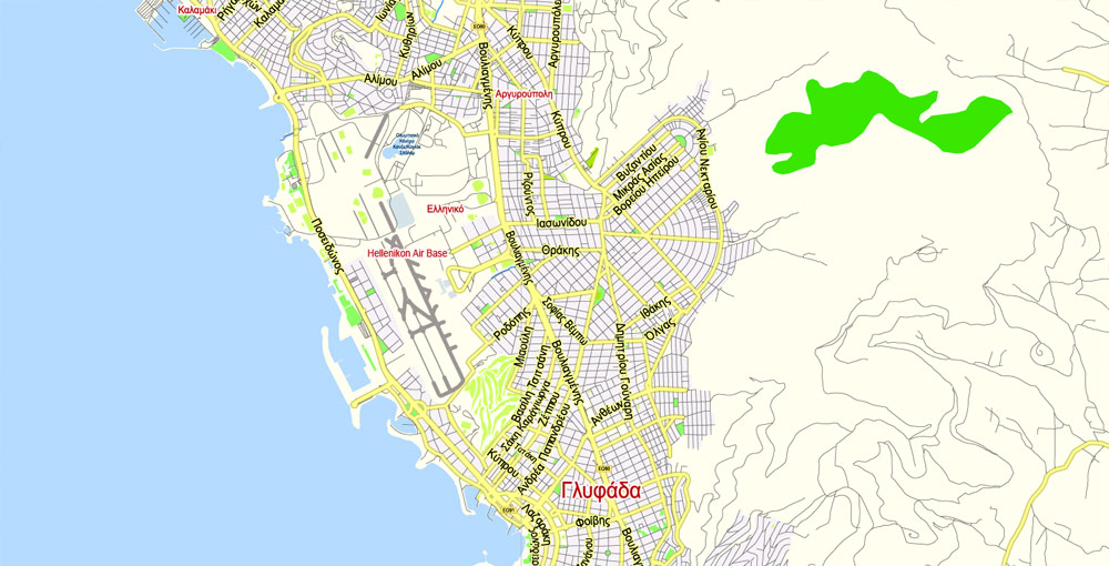
The Athens Metropolitan Area consists of 58 densely populated municipalities, sprawling around the municipality of Athens (the city centre) in virtually all directions. For the Athenians, all the urban municipalities surrounding the city centre are called suburbs. According to their geographic location in relation to the City of Athens, the suburbs are divided into four zones; the northern suburbs (including Agios Stefanos, Dionysos, Ekali, Nea Erythraia, Kifissia, Maroussi, Pefki, Lykovrysi, Metamorfosi, Nea Ionia, Nea Filadelfeia, Irakleio, Vrilissia, Melissia, Penteli, Chalandri, Agia Paraskevi, Galatsi, Psychiko and Filothei); the southern suburbs (including Alimos, Nea Smyrni, Moschato, Kallithea, Agios Dimitrios, Palaio Faliro, Elliniko, Glyfada, Argyroupoli, Ilioupoli, Voula and Vouliagmeni); the eastern suburbs (including Zografou, Dafni, Vyronas, Kaisariani, Cholargos and Papagou); and the western suburbs (including Peristeri, Ilion, Egaleo, Koridallos, Agia Varvara, Chaidari, Petroupoli, Agioi Anargyroi and Kamatero).
The Athens city coastline, extending from the major commercial port of Piraeus to the southernmost suburb of Varkiza for some 25 km (20 mi), is also connected to the city centre by a tram.
In the northern suburb of Maroussi, the upgraded main Olympic Complex (known by its Greek acronym OAKA) dominates the skyline. The area has been redeveloped according to a design by the Spanish architect Santiago Calatrava, with steel arches, landscaped gardens, fountains, futuristic glass, and a landmark new blue glass roof which was added to the main stadium. A second Olympic complex, next to the sea at the beach of Palaio Faliro, also features modern stadia, shops and an elevated esplanade. Work is underway to transform the grounds of the old Athens Airport – named Elliniko – in the southern suburbs, into one of the largest landscaped parks in Europe, to be named the Hellenikon Metropolitan Park.
Many of the southern suburbs (such as Alimos, Palaio Faliro, Elliniko, Glyfada, Voula, Vouliagmeni and Varkiza) known as the Athens Riviera, host a number of sandy beaches, most of which are operated by the Greek National Tourism Organisation and require an entrance fee. Casinos operate on both Mount Parnitha, some 25 km (16 mi) from downtown Athens (accessible by car or cable car), and the nearby town of Loutraki (accessible by car via the Athens – Corinth National Highway, or the suburban rail service Proastiakos).
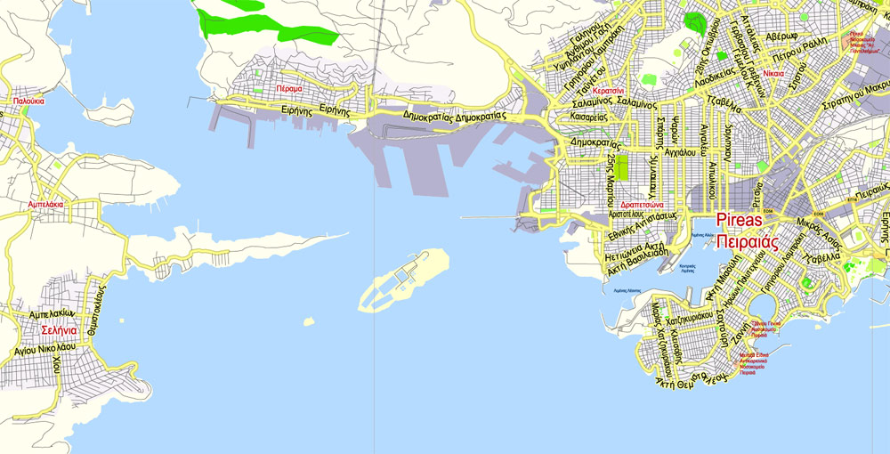
Piraeus is a port city in the region of Attica, Greece. Piraeus is located within the Athens urban area, 12 kilometres (7 miles) southwest from its city center (municipality of Athens), and lies along the east coast of the Saronic Gulf.
According to the 2011 census, Piraeus had a population of 163,688 people within its administrative limits, making it the fourth largest municipality in Greece and the second largest within the urban area of the Greek capital, following the municipality of Athens. The municipality of Piraeus and several other suburban municipalities within the regional unit of Piraeus form the greater Piraeus area, with a total population of 448,997.
Piraeus has a long recorded history, dating to ancient Greece. The city was largely developed in the early 5th century BC, when it was selected to serve as the port city of classical Athens and was transformed into a prototype harbour, concentrating all the import and transit trade of Athens. During the Golden Age of Athens the Long Walls were constructed to fortify Athens and its port (Piraeus). Consequently, it became the chief harbour of ancient Greece, but declined gradually after the 4th century AD, growing once more in the 19th century, after Athens’ declaration as the capital of Greece. In the modern era, Piraeus is a large city, bustling with activity and an integral part of Athens, acting as home to the country’s biggest harbour and bearing all the characteristics of a huge marine and commercial-industrial centre.
The port of Piraeus is the chief port in Greece, the largest passenger port in Europe and the second largest in the world, servicing about 20 million passengers annually. With a throughput of 1.4 million TEUs, Piraeus is placed among the top ten ports in container traffic in Europe and the top container port in the Eastern Mediterranean. The city hosted events in both the 1896 and 2004 Summer Olympics held in Athens. The University of Piraeus is one of the largest universities in Greece.
Geography
Piraeus is situated in the southwest part of the central plain of Attica, also widely known as the Athens or Attica Basin, which the Athens agglomeration (urban area) sprawls across. Piraeus is bounded by the Mount Aigaleo to the northwest, and the Saronic Gulf to the south and west, and connected with the rest of the Athens Urban Area to the east and northeast. The “city proper” of Piraeus consists of a rocky peninsula, originally an island, featuring three natural harbours. In addition to the central one, called Kantharos in ancient times, the smaller harbours to the east are still in use : Zea, also known as Pasalimani, and Munichia, the smallest of the three and widely known as Mikrolimano. Nowadays, the Greater Piraeus includes the harbours of Drapetsona, Keratsini and Perama. The central harbour is a hub of commercial and passenger shipping, whereas the two smaller ones cater to recreational and fishing craft as well as passenger hydrofoils. The municipality has an area of 10.865 km2
Athens
Capital of Greece
Athens is the capital of Greece. It was also at the heart of Ancient Greece, a powerful civilization and empire. The city is still dominated by 5th-century BC landmarks, including the Acropolis, a hilltop citadel topped with ancient buildings like the colonnaded Parthenon temple. The Acropolis Museum, along with the National Archaeological Museum, preserves sculptures, vases, jewelry and more from Ancient Greece.
Area
• Municipality 38.964 km2 (15.044 sq mi)
• Urban 412 km2 (159 sq mi)
• Metro 2,928.717 km2 (1,130.784 sq mi)
Highest elevation 338 m (1,109 ft)
Lowest elevation 70 m (230 ft)
Population
• Municipality 664,046
• Rank 1st urban, 1st metro in Greece
• Urban 3,090,508
• Urban density 7,500/km2 (19,000/sq mi)
• Metro 4,173,542
• Metro density 1,400/km2 (3,700/sq mi)
Free vector maps:

Free download printable map Europe vector Adobe Illustrator >>>
Free download printable PDF map Europe vector Adobe PDF >>>
Small guide: How to work with the vector map?
You can: Mass select objects by type and color – for example, the objects type “building” (they are usually dark gray) – and remove them from the map, if you do not need them in your print or design project. You can also easily change the thickness of lines (streets), just bulk selection the road by the line color.
The streets are separated by type, for example, type “residential road” are usually white with a gray stroke. Highway usually orange with a brown or dark gray stroke.
It is easy to change the font of inscriptions, all or each individually. Also, just can be make and any other manipulation of objects on the vector map in Adobe illustrator format.
Important: All the proportions on the map are true, that is, the relative sizes of the objects are true, because Map is based on an accurate GPS projection, and It transated into the (usual for all) the Mercator projection.
You can easily change the color, stroke and fill of any object on the map, zoom without loss of quality Image Verification.
Select object

Bulk selection the same objects on the vector map

See the bulk selected objects on the vector map

Bulk delete buildungs from the vector map

Select residencial road (small street) on the vector map

Bulk selection the same lines (streets, roads) on the full map

Create fat lines of the streets on the vector maps (bulk action) 1

Create fat lines of the streets on the vector maps (bulk action) 2

Create fat lines of the streets on the vector maps (bulk action) 3

You can easily change the color, stroke and fill of any object on the map, zoom without loss of quality Image Verification.

 Author: Kirill Shrayber, Ph.D. FRGS
 map English, fully editable, Adobe Illustrator")
 map Greek, fully editable, Adobe Illustrator")
 map, V.27.11. ENGLISH, fully editable, Adobe Illustrator")

