Extended Description of the Vector Map
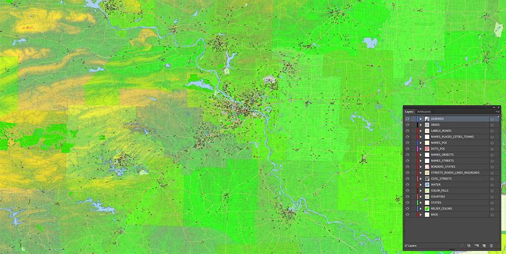
Printable Colored Relief PDF Vector Map of Arkansas State, US High Detailed Plan full editable Adobe PDF Road Admin Map in layers, scalable, text format all names, 333 MB ZIP
All streets and roads, Principal street names, All Cities and Towns, Airports and Heliports, Main Objects, Counties, raster Colored Relief HD. Map for design, printing, arts, projects, presentations, for architects, designers, and builders, business, logistics.
The most exact and detailed map of the state in scale.
For Editing and High-Quality Printing, Royalty free
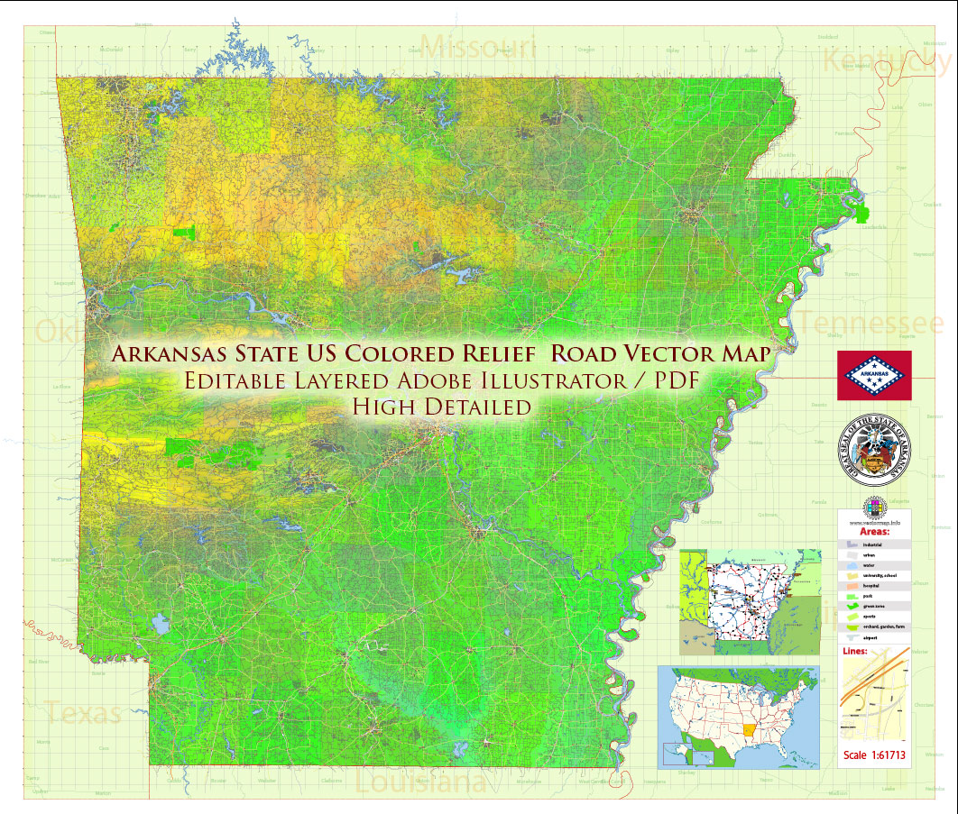
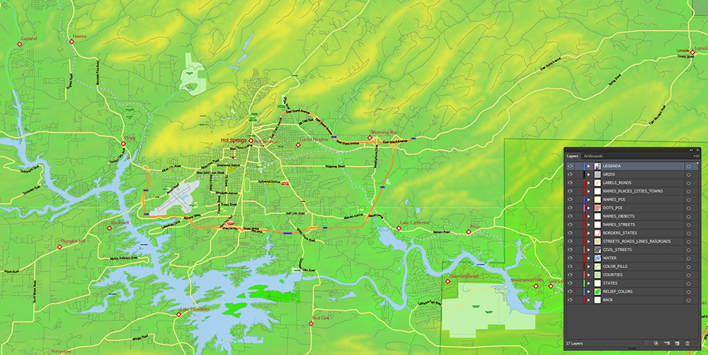
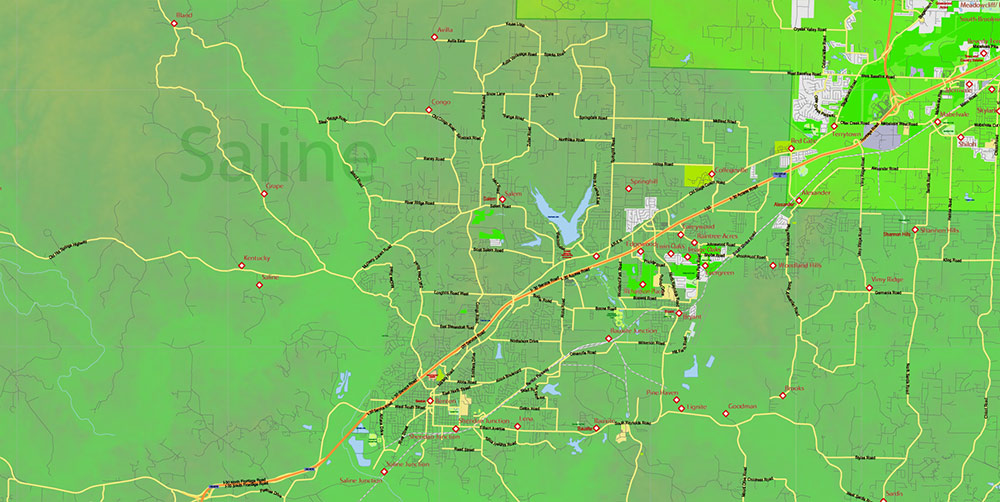
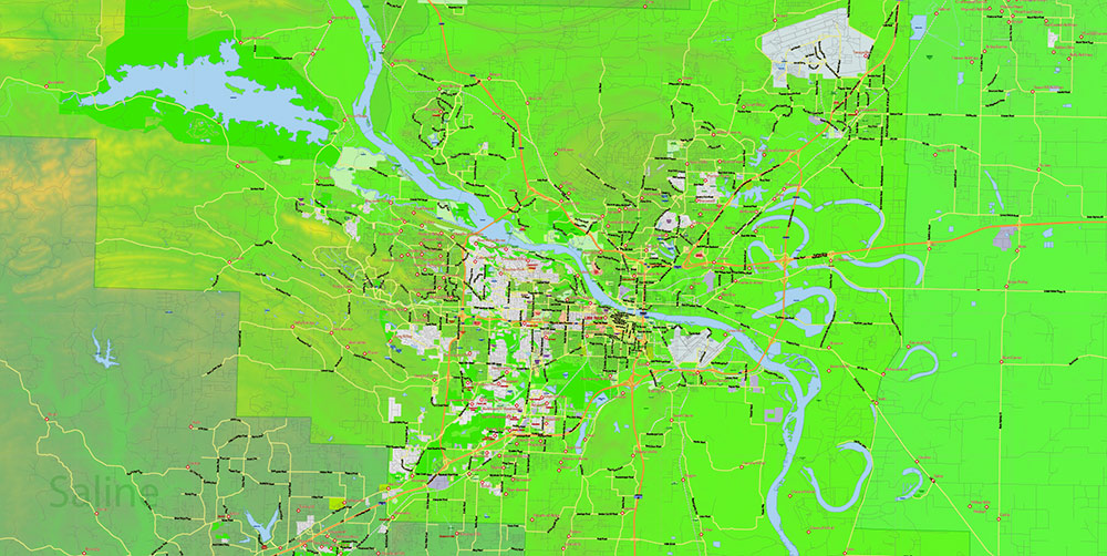
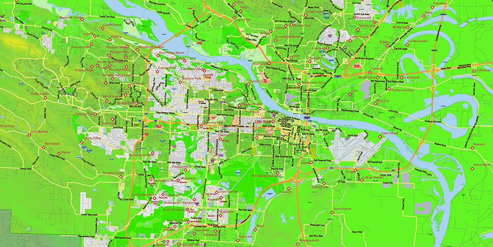
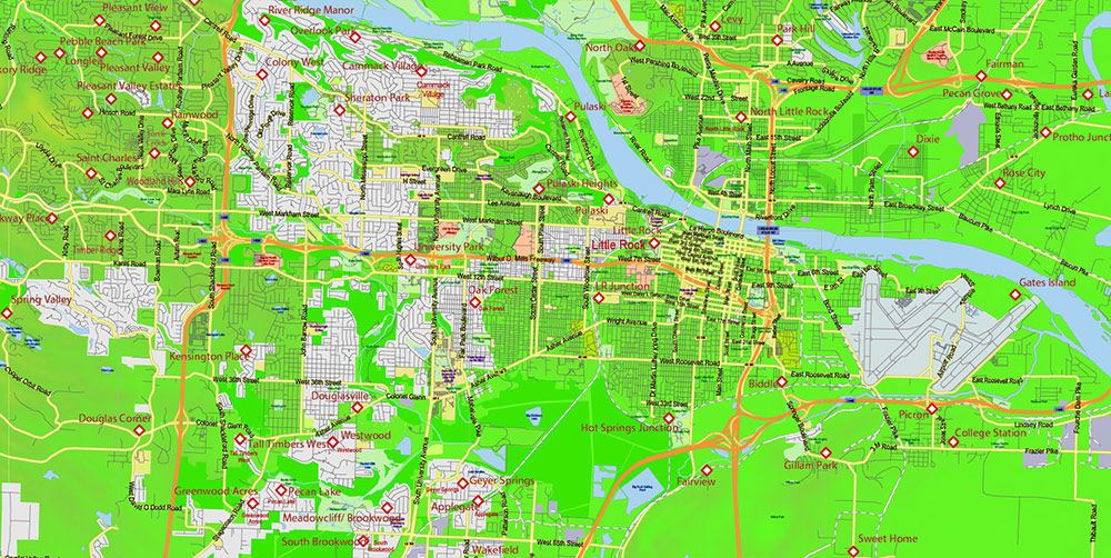
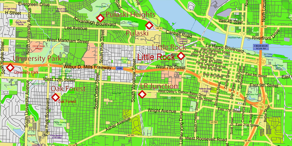
Arkansas State US PDF Map Vector Exact Colored Relief and Roads High Detailed Map + Counties editable Adobe PDF in layers
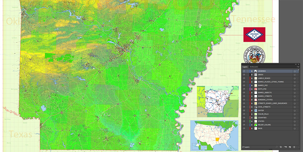
Layers list:
- Legend
- Grids
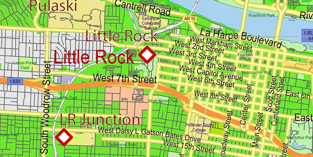
- Labels of roads
- Names of places (city, hamlet, etc.)
- Points of the Cities and Towns
- Airports and Heliports names
- Points of the Airports and Heliports
- Names of objects (hospitals, schools, parks, water)
- Names of main streets
- Names of Counties
- Principal Streets and Roads
- Residential streets
- Railroads
- Airports and Heliports areas
- Water objects (rivers, lakes, ponds)
- Waterways
- Color fills (parks, hospital areas, school areas, land use, etc.)
- Counties areas
- Colored Relief Raster JPG HD
- Background
Arkansas State US PDF Map Vector Exact Colored Relief and Roads High Detailed Map + Counties editable Adobe PDF in layers
AO BRIEF – Arkansas, USA
GENERAL CHARACTER
Arkansas is an inland, south-central U.S. state with pronounced internal contrasts in terrain, settlement density, and economic function. It acts as a transitional zone between the Deep South, the Midwest, and the southern Plains. Operationally, the state is corridor-driven: movement, logistics, and population are concentrated along a limited number of highways and river valleys.
GEOGRAPHY & PHYSICAL TERRAIN
Major Physiographic Regions
-
Ozark Plateau (North & Northwest):
-
Dissected highland with steep ridges, narrow valleys, karst features, caves, and forests.
-
Terrain restricts lateral movement; road control is decisive.
-
Sparse rural population outside urban clusters.
-
Ouachita Mountains (West–Southwest):
-
Folded east–west mountain chains, unlike the north–south Ozarks.
-
Few natural crossings; movement funnels through gaps and valleys.
-
Heavily forested, low visibility, limited agriculture.
-
Arkansas River Valley (Central Belt):
-
Broad corridor separating Ozarks and Ouachitas.
-
Flatter terrain, historically a transport and settlement axis.
-
Key east–west mobility zone.
-
Mississippi Alluvial Plain / Delta (East):
-
Flat, low-lying floodplain.
-
Intensive agriculture, minimal natural cover.
-
High flood exposure; ground saturation affects heavy movement.
Climate
-
Humid subtropical.
-
Hot summers, mild winters.
-
Severe weather risk: thunderstorms, tornadoes, flash floods.
-
Weather is a recurring operational constraint rather than an exception.
MAJOR URBAN & REGIONAL CENTERS
-
Little Rock
-
State capital and primary command, administrative, and logistics hub.
-
Located on the Arkansas River; key bridge crossings.
-
Political and transport gravity center of the state.
-
Fayetteville
-
University city, knowledge economy, and growth pole.
-
Part of a continuous NW urban corridor.
-
Springdale
-
Fort Smith
-
Jonesboro
-
Pine Bluff
LINES OF COMMUNICATION (ROADS & TRANSPORT)
Primary Interstate Network
-
I-40: Dominant east–west artery; links Mississippi River crossings to Oklahoma and beyond.
-
I-30: Southwest axis connecting Little Rock to the Dallas–Fort Worth metroplex.
-
I-49: Strategic north–south corridor in the west, linking the Ozarks to the Plains.
-
I-55: Runs along the Mississippi River on the eastern edge.
Secondary Routes
-
US-67/167 (Central–Northeast axis).
-
US-65 (north–south central).
-
US-71 (western internal connector).
Assessment:
Control of a small number of highway interchanges and river crossings effectively governs statewide mobility.
WATER RESOURCES & HYDROLOGY
-
Mississippi River: Defines the eastern boundary; major commercial and strategic waterway.
-
Arkansas River: Fully navigable through the state; connects to the Mississippi via lock-and-dam systems.
-
White River System: Extensive reservoirs supporting hydropower, flood control, and water supply.
-
Red River Tributaries: Drainage influence in the southwest.
-
Artificial Lakes: Critical for power, water security, and recreation.
Operational Note:
Flood cycles periodically degrade ground mobility and disrupt logistics, especially in the Delta and river valleys.
ECONOMIC & INFRASTRUCTURE PROFILE
-
Agriculture: Rice, soybeans, poultry dominate rural output.
-
Industry: Food processing, logistics, light manufacturing.
-
Energy: Hydropower supplemented by regional grid connections.
-
Infrastructure Quality: Strong along corridors; weak redundancy in rural zones.
DEMOGRAPHY / HUMAN TERRAIN
RISKS, LIMITATIONS & CONSTRAINTS
-
Severe weather events disrupt operations and infrastructure.
-
Floodplains limit heavy equipment use seasonally.
-
Forested highlands restrict surveillance and off-road maneuver.
-
Sparse population reduces local support capacity in rural AO.
COMMAND-LEVEL TAKEAWAYS
-
Arkansas is corridor-centric: highways and rivers define control.
-
Little Rock + I-40 crossings are decisive strategic nodes.
-
Northwest Arkansas is the most dynamic, resilient, and demographically stable region.
-
Terrain favors logistics, staging, and transit control rather than dense urban operations.
-
Weather and hydrology must be treated as operational variables, not background conditions.
If you want, I can produce:
-
a compressed one-page AO card,
-
a logistics-only version, or
-
a military shorthand variant with map-grid logic and priority nodes.
Arkansas State US PDF Map Vector Exact Colored Relief and Roads High Detailed Map + Counties editable Adobe PDF in layers
Arkansas State US PDF Map Vector Exact Colored Relief and Roads High Detailed Map + Counties editable Adobe PDF in layers
Arkansas State US PDF Map Vector Exact Colored Relief and Roads High Detailed Map + Counties editable Adobe PDF in layers
Arkansas State US PDF Map Vector Exact Colored Relief and Roads High Detailed Map + Counties editable Adobe PDF in layers
Arkansas State US PDF Map Vector Exact Colored Relief and Roads High Detailed Map + Counties editable Adobe PDF in layers
Arkansas State US PDF Map Vector Exact Colored Relief and Roads High Detailed Map + Counties editable Adobe PDF in layers
Arkansas State US PDF Map Vector Exact Colored Relief and Roads High Detailed Map + Counties editable Adobe PDF in layers
Arkansas State US PDF Map Vector Exact Colored Relief and Roads High Detailed Map + Counties editable Adobe PDF in layers
Arkansas State US PDF Map Vector Exact Colored Relief and Roads High Detailed Map + Counties editable Adobe PDF in layers

 Author: Kirill Shrayber, Ph.D. FRGS


