Albany is a city in the northeastern United States, the capital of the state of New York and Albany County. The population of the city proper is 107.2 thousand, the population of the urban agglomeration is 1020.3 thousand people.
Geographical information
Albany has located about 240 km (150 miles) north of New York City, just south of the confluence of the Mohawk River with the Hudson River. It is located on the west bank of the Hudson River, on which there is a major port. The Hudson River was deepened so that the port could receive sea vessels. The territory of the city is quite hilly, the highest point (in the northwest) is 99 meters above sea level, the lowest is the average level of the Hudson River (average, since the tide reaches Albany and affects the river level) is only 0.6 meters.
It is closely associated with the neighboring cities of Troy, Schenectady, and Saratoga Springs, with which it forms the Metropolitan Area, one of the historic regions of the United States. The main part of this district is the urban agglomeration of Albany — Schenectady — Troy, which is the fourth largest in the state of New York and the 56th in the United States.
Albany is one of the oldest surviving European settlements in the thirteen colonies and the oldest continuously inhabited city in the United States. Before the arrival of Europeans, the area was inhabited by Native American tribes of the Algonquian group. The first European settlement on the site of Albany was a small wooden fortress built by French traders in 1540 on an island on the Hudson River. It was destroyed by a flood shortly after construction was completed.
The permanent European presence in the territory began when the Englishman Henry Hudson, who was looking for new land for the Dutch East India Company on the ship Halve Maen, landed here in 1609, declaring the territory the property of the United Provinces of the Netherlands. In 1614, Hendrik Christiansen rebuilt the old French fort as Fort Nassau, the first Dutch fur trading post in the area. The beginning of the fur trade provoked hostility from the French colony in Canada and among the locals, and the French and Indians themselves wanted to control the trade. In 1618, a flood again destroyed the fortress on the island, but it was rebuilt in 1624 as Fort Orange. Fort Orange and the surrounding area were incorporated into the village of Beverwijck in 1652.
When New Netherland was invaded by the British in 1664, the name was changed to Albany, in honor of James II, Duke of Albany. The Dutch briefly regained control of the city in August 1673 and renamed it Willemstadt, but in 1674 the Treaty of Westminster finally gave the territory to the British. On November 1, 1683, the province of New York was divided into counties, the largest of which was Albany County. At the time, the district included all of present-day New York State north of Dutchess and Ulster Counties, as well as present-day Bennington County, Vermont, theoretically extending west to the Pacific Ocean. Albany was officially recognized as a city by Provincial Governor Thomas Dungan on July 22, 1686. The Dungan Charter was virtually identical in content to the charter of the City of New York, which Dungan had approved three months earlier. The population of Albany at that time was about 500 people.
In 1754, representatives of the seven British colonies met in the town hall at the Albany Convention, where Benjamin Franklin first proposed a plan for the unification of the colonies. Although the plan was not passed by Congress, it was an important step toward the Constitution of the United States. After the French defeat in the Seven Years ‘ War and the British occupation of New France, the military threat to Albany disappeared, which accelerated the development of the city. During the Revolutionary War, Albany was one of the rear bases of the separatists, the city housed a prisoner of war camp.
During and after the war, the city experienced a significant influx of refugees, attracted both by the lack of fighting and by Albany’s favorable geographical location. At the first national census in 1790, the number of citizens was 3,498, an increase of almost 700 % since the approval of the city charter. In 1797, the state capital was moved to Albany from New York (due to fears of an English landing on the coast). Albany is the second oldest state capital after Santa Fe.
Albany has been an important transportation hub for most of its history. In the late 18th and early 19th centuries, toll roads were actively built in New York State, and by 1815, Albany was the center of its network. Combined with a deep-water canal for shipping and the construction of railroads, this made the city a transit center for the flow of immigrants moving from New York to Buffalo and on to the Michigan territory in the early and mid-19th century.
In 1807, Robert Fulton launched a steamship line from New York to Albany, the first successful venture of its kind in the United States. By 1810, with 10,763 residents, Albany was the 10th largest city in the country. In 1825, the Erie Canal was completed, forming a continuous waterway from the Great Lakes to New York. According to the 1830 and 1840 censuses, Albany ranked ninth in the country in terms of population, then dropped back to the tenth position in 1850. This was the last time the city was among the top ten largest in the United States.
The history of the city is also closely connected with railway transport. Albany was for many years the headquarters of two major railroad companies: the Delaware and Hudson Railway and the New York Central Railroad.
Excellent infrastructure contributed to the rapid economic development of the city and the influx of new immigrants.
In 1908, Albany opened the first municipal airport in the United States (also one of the first commercial airports in the world).
The history of the city in the second half of the XX century is inextricably linked with the name of one person. Erastus Corning 2nd, perhaps the most famous mayor of Albany and the great-grandson and namesake of the former mayor, was elected in 1941. Although he was the longest-serving mayor of any city in the history of the United States from 1942 until his death in 1983, many historians describe Corning’s tenure as “a long stagnation”, hinting at his opposition to any drastic changes in city life. At the same time, residents give Corning credit for preserving, if somewhat unintentionally, much of Albany’s historic architecture.
In the 1950s and 1960s, a time when federal aid for urban renewal was lavished by Washington, there was little new construction of roads, skyscrapers, and shopping centers in Albany. The city lost more than 20 % of its population during the Corning years, with most businesses moving from the center to the suburbs. However, supporters of the mayor (and he was always supported by the majority of citizens) reasonably objected to critics that similar processes took place in all major cities of the United States.
After the death of Erastus Corning in 1983, he was succeeded by Thomas Whelen (who was re-elected twice afterward). Albany received a significant influx of federal funds intended for the restoration of historic buildings. What To Corning saved from destruction was repaired under Whelen. Many new buildings were also erected in the city, and the infrastructure was significantly improved.
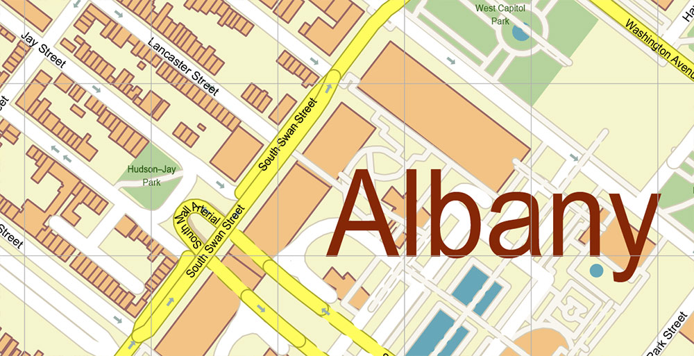
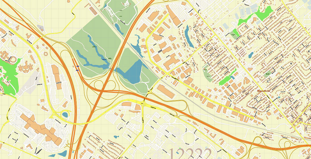
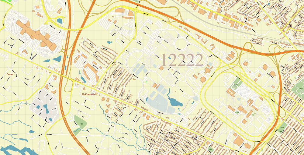
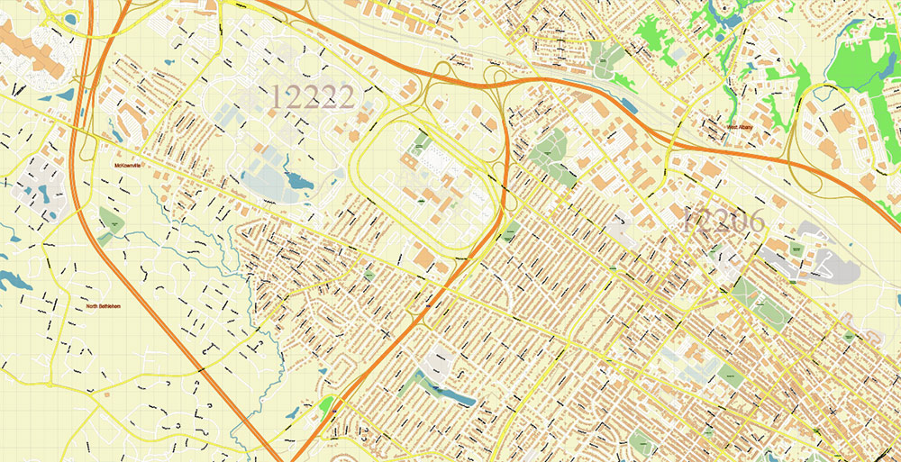
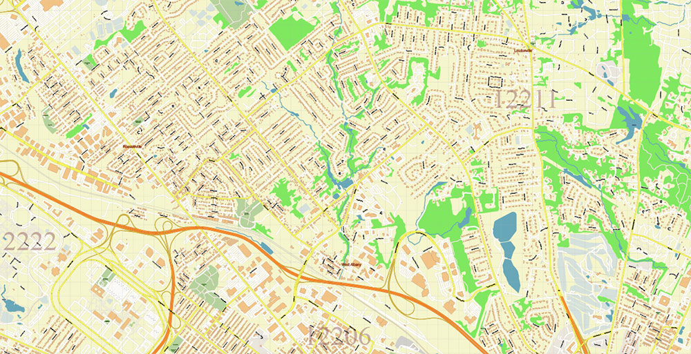
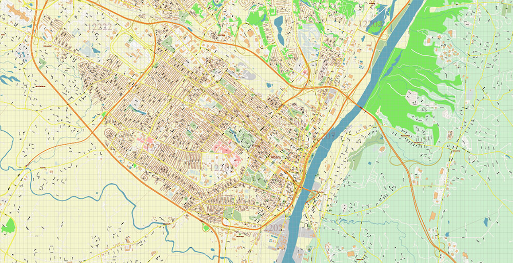
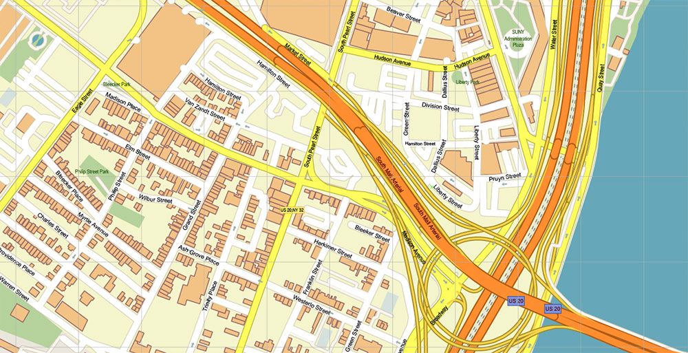
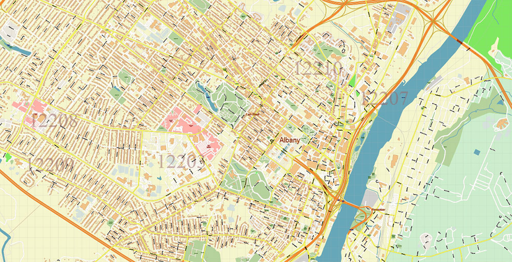
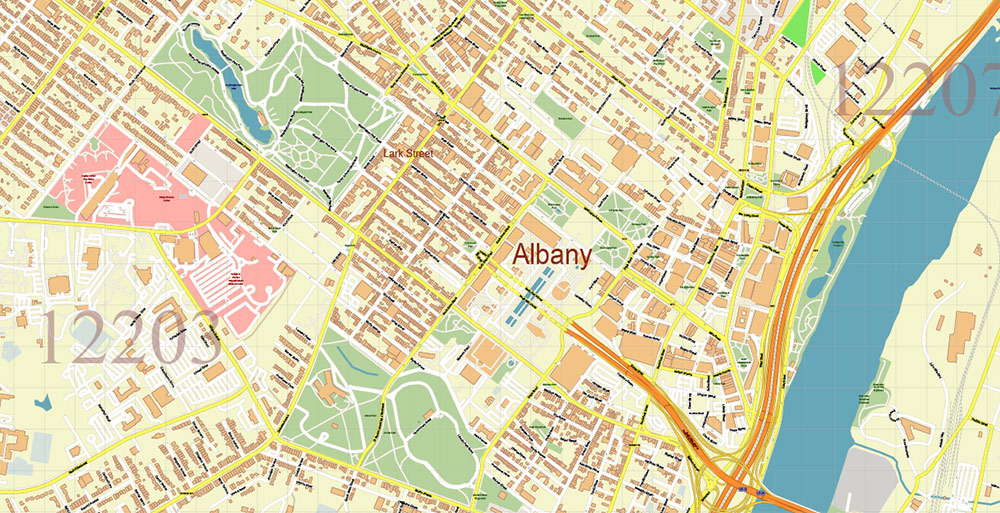
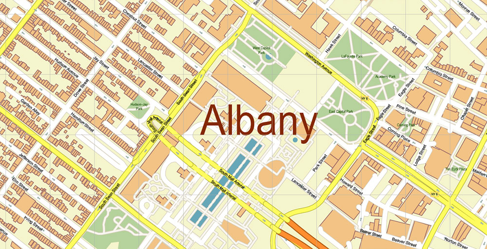
Printable PDF Vector Map of Albany County New York US high detailed City Plan + Counties areas + Zipcodes areas and numbers, scale 1:3458 full editable Adobe PDF Street Map in layers, scalable, text format all names, 84 MB ZIP
All street names, Main Objects, Buildings. Map for design, printing, arts, projects, presentations, for architects, designers, and builders, business, logistics.
Included: Simple vector map of New York State.
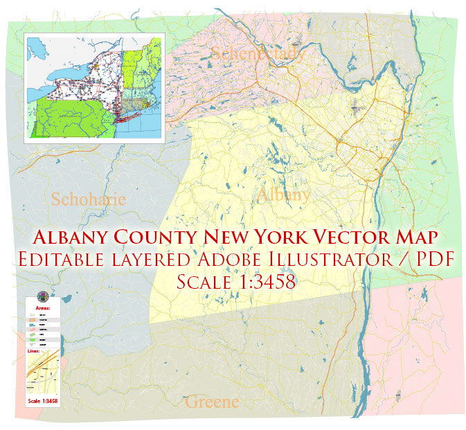
Albany County New York US PDF Vector Map Exact State Plan High Detailed Road Map + admin + Zipcodes editable Adobe PDF in layers
Layers list:
- Legend
- Grids
- Labels of roads
- Names of places (city, hamlet, etc.)
- Names of objects (hospitals, parks, water)
- Names of main streets
- Names of civil streets
- Names of Counties
- Numbers of ZIPcodes
- Main Streets, roads
- Civil streets
- Railroads
- Buildings
- Airports and heliports
- Water objects (rivers, lakes, ponds)
- Waterways
- Color fills (parks, hospital areas, land use, etc.)
- ZIPcodes areas
- Counties areas
- Background
Albany County New York US PDF Vector Map Exact State Plan High Detailed Road Map + admin + Zipcodes editable Adobe PDF in layers
Albany County New York US PDF Vector Map Exact State Plan High Detailed Road Map + admin + Zipcodes editable Adobe PDF in layers
Albany County New York US PDF Vector Map Exact State Plan High Detailed Road Map + admin + Zipcodes editable Adobe PDF in layers
Albany County New York US PDF Vector Map Exact State Plan High Detailed Road Map + admin + Zipcodes editable Adobe PDF in layers
Albany County New York US PDF Vector Map Exact State Plan High Detailed Road Map + admin + Zipcodes editable Adobe PDF in layers
Albany County New York US PDF Vector Map Exact State Plan High Detailed Road Map + admin + Zipcodes editable Adobe PDF in layers
Albany County New York US PDF Vector Map Exact State Plan High Detailed Road Map + admin + Zipcodes editable Adobe PDF in layers
Albany County New York US PDF Vector Map Exact State Plan High Detailed Road Map + admin + Zipcodes editable Adobe PDF in layers
Albany County New York US PDF Vector Map Exact State Plan High Detailed Road Map + admin + Zipcodes editable Adobe PDF in layers
Albany County New York US PDF Vector Map Exact State Plan High Detailed Road Map + admin + Zipcodes editable Adobe PDF in layers


 Author: Kirill Shrayber, Ph.D. FRGS


