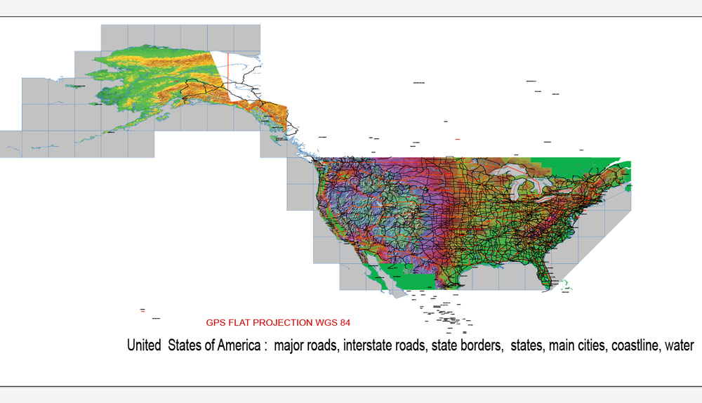
Vector map of USA in Adobe Illustrator [.AI]
Archive size: 12 Mb
Projection: GPS WGS-84
[Available in PDF and other formats: .DWG; .AI; .EPS; .CDR; .PPT.]
Very accurate vector map of United States of America in [.AI] format, also can be purchased in other formats for the same price.
This USA vectorial map has:
Major roads
States borders
Main cities with names
Lakes
Rivers
Coastline
Interstate roads
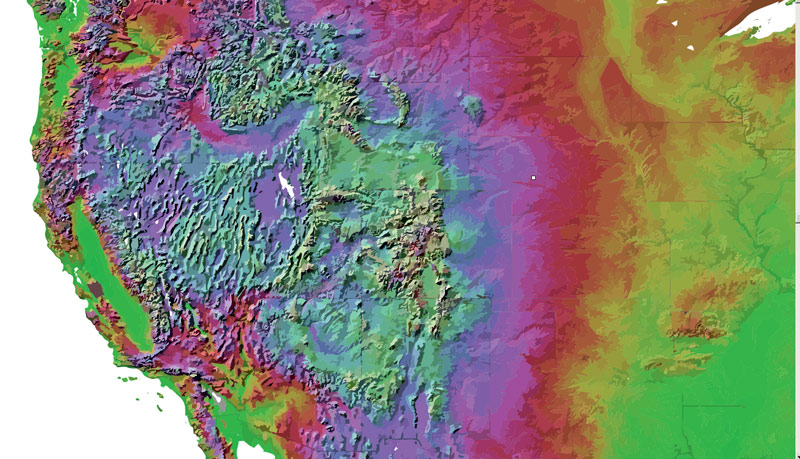
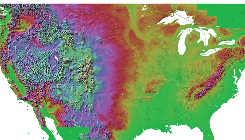
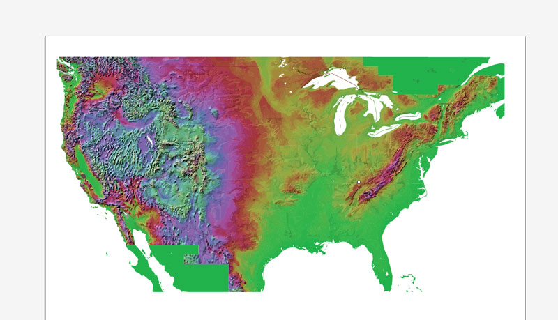
Relief
Bays
Please see the attached preview images.
Need more data on this Illustrator map of USA? No problem, just write or call us.
United States of America (USA).
The USA map in vector format is used for design, urban planning, presentations and media visualizations.
The advertising and presentation map of USA (usually the final designer marks the routes, and puts the client’s objects (shops, saloons, gas stations etc.)
The undoubted advantage is that people will NEVER throw out this advertising product – the map. In fact, as an advertising medium, a map is the most “long-playing” of the well-known polygraphic advertising media, with the longest lifespan, and the maximum number of interactions with the customer.
For travelers, maps are sold at the airports and gas stations around the world. Often the source is our vector maps.
Take a look, who purchases our vector maps of USA in “Our Clients and Friends” page – these are large and small companies, from super-brands like Volvo and Starbucks, to small design studios and printing houses.
It’s very easy to work with vector maps of USA city, even for a not very experienced designer who can turn on and off the map layers, add new objects, change the colors of fill and lines according to customer requirements.
The undoubted advantage of USA vector maps in printing is an excellent and detailed visualization, when customer can expand a large paper map and instantly define his location, find a landmark, an object or address on map, unlike using the popular electronic formats of Google and Yandex maps for example.
Printable vector maps of USA are much more convenient and efficient than any electronic maps on your smartphone, because ALL DETAILS are displayed in the entire space of USA map.
Paleo-Indians migrated from Siberia to the North American mainland at least 15,000 years ago. European colonization began in the 16th century. The United States emerged from the thirteen British colonies established along the East Coast. Numerous disputes between Great Britain and the colonies following the French and Indian War led to the American Revolution, which began in 1775, and the subsequent Declaration of Independence in 1776. The war ended in 1783 with the United States becoming the first country to gain independence from a European power.
Useful tips on working with vector maps of cities and countries in Adobe Illustrator.
«V» – launches the Selection tool (cursor, black arrow), which makes active any vector line.
«А» – launches the Direct Selection tool (white cursor), allows you to select curve elements and drag them to the desired place.
«R» – activates the Rotate tool, which helps you rotating selected objects around the center point by 360 degrees.
«E» – gives you the opportunity to use the Eraser tool and erase unnecessary parts.
«X» – switches between Fill and Stroke in the Tools section. Try to get used to this hot key and
you will quickly understand that you can’t live and work without it.
Guides are not limited to vertical and horizontal in Adobe Illustrator. You can also create a diagonal guide for example. Moreover, you can turn any contours into guides. Select the outline and go to View > Guides > Make Guides (Create Guides), or simply press Cmd/Ctrl + 5. You can also turn the guides back into an editable object. Go to menu, View > Guides > Unlock Guides (Release Guides), select the guide you want to edit and select View > Guides > Release Guides (Reset Guides), or just press Cmd/Ctrl + Option / Alt + 5).
You will probably want to change the color scheme used on our USA vector map.
To quickly and effectively play with colors.
Of course, you can do it manually, all objects in our USA vector map are divided according to types and layers, and you can easily change the color gamma of vector objects in groups and layers.
But there is more effective way of working with the whole VECTOR MAP of USA and all layers:
The overview dialog «Edit colors»/«Repaint Graphic Object» (this dialog box name can change depending on the context):
If you have selected a part or a layer of USA vector map and open the dialog box by clicking the icon in the Control panel, on the Samples palette or the Color Catalog, or if you choose Edit > Edit Colors> Repaint Graphic Object, then the «Repaint Graphic Object» dialog box appears, and you get access to «Assign» and «Edit» tabs.
If a picture or a map fragment is not selected, and you open the dialog box by clicking the icon in the Control panel, on the Samples palette or in the Color Catalog, the «Edit Colors» dialog box appears and you can only access the «Edit» tab.
Regardless of the name at the top of the dialog box, the right-hand side always displays the color group of the current document, as well as two default color groups: Print Color and Grayscale. These color groups can be selected and used any time.
Create and edit color groups of USA vector map, and also assign colors using the «Edit Colors»/ а «Repaint Graphic Object» dialog box.
A. Creating and editing of a color group on the «Edit» tab
B. Assigning colors on the «Assign» tab
C. Select a group of colors from the «Color groups» list
The option «Repaint a graphic object» in the lower part of the dialog box allows you to preview the colors on a selected layer of Vector map, or a group of elements, and specify whether its colors will be redefined when the dialog box is closed.
The current constitution was adopted in 1788, with the first ten amendments, collectively named the Bill of Rights, being ratified in 1791 to guarantee many fundamental civil liberties. The United States embarked on a vigorous expansion across North America throughout the 19th century, acquiring new territories, displacing Native American tribes, and gradually admitting new states until it spanned the continent by 1848. During the second half of the 19th century, the Civil War led to the abolition of slavery.
By the end of the century, the United States had extended into the Pacific Ocean, and its economy, driven in large part by the Industrial Revolution, began to soar. The Spanish–American War and World War I confirmed the country’s status as a global military power. The United States emerged from World War II as a global superpower, the first country to develop nuclear weapons, the only country to use them in warfare, and a permanent member of the United Nations Security Council. During the Cold War, the United States and the Soviet Union competed in the Space Race, culminating with the 1969 moon landing. The end of the Cold War and the collapse of the Soviet Union in 1991 left the United States as the world’s sole superpower.
The main areas of the dialog box are:
«Edit»
The «Edit» tab is designed to create a new or edit the existing color groups.
The harmony rules Menu and the Color Wheel are used to conduct experiments with color harmonies. The color wheel shows how colors are related in color harmony, and the color bars allow you to view and manipulate an individual color values. In addition, you can adjust the brightness, add and remove colors, save color groups and view colors on the selected Vector Map of USA or a separated layers.
«Assign»
The «Assign» tab is used to view and control on how the original colors are replaced with colors from the color group like your corporate colors in the Vector Map of USA city.
The assign color ability is provided only if the entire map, layer or fragment is selected in the document. You can specify which of new colors replace the current colors, whether the spot colors should be preserved and how colors are replaced (for example, you can replace colors completely or changing the color tone while maintaining the brightness). The «Assign» tab allows you to redefine colors in the Vector Map of USA city, or in separate layers and fragments using the current color group or reducing the number of colors in the current Vector Map.
Color groups
Is a list of all saved color groups for current document (the same groups appear in the «Samples» palette). You can edit and delete the existing color groups, as well as creating a new ones using the list of “Color Groups” in the dialog box. All changes appear in the «Samples» palette.
The United States is the world’s oldest surviving federation. It is a federal republic and a representative democracy, “in which majority rule is tempered by minority rights protected by law”. The United States is a founding member of the United Nations, World Bank, International Monetary Fund, Organization of American States (OAS), and other international organizations. The United States is a highly developed country, with the world’s largest economy by nominal GDP and second-largest economy by PPP, accounting for approximately a quarter of global GDP. The U.S. economy is largely post-industrial, characterized by the dominance of services and knowledge-based activities, although the manufacturing sector remains the second-largest in the world. The United States is the world’s largest importer and the second largest exporter of goods, by value. Although its population is only 4.3% of the world total, the U.S. holds 33% of the total wealth in the world, the largest share of global wealth concentrated in a single country. The United States ranks among the highest nations in several measures of socioeconomic performance, including human development, per capita GDP, and productivity per person, while experiencing a substantial amount of income and wealth inequality. The United States is the foremost military power in the world, making up a third of global military spending, and is a leading political, cultural, and scientific force internationally.
The highlighted color group shows, which color group is currently edited.
Any color group can be selected and edited, or used to redefine the colors in the selected vector map of USA city, its fragments or elements.
Saving a color group adds this group to the specified list.
Opening the «Edit Colors»/«Repaint Graphic Object» dialog box.
Open the «Edit Colors»/«Repaint Graphic Object» dialog box using one of the following methods:
«Edit»> «Edit Colors»> «Repaint Graphic object» or «Repaint With Style».
Use these commands if you need to edit the colors in the selected vector map of USA city.
«Repaint Graphic object» button on the «Control» panel.
Use this button if you need to adjust colors of USA vector map using the а «Repaint graphic object» dialog box.
The specified button is available if the selected vector map or its fragment contains two or more colors.
Note. This color editing method is convenient for global color adjustment in a vector map, if global colors were not used when creating a Map of USA.
The «Edit colors» button or «Edit or apply colors» on the «Color Catalog» palette
Click this button if you need to edit colors on the «Color Catalog» palette or edit and then apply them to the selected Vector Map of USA or its fragment.
The «Edit color group» button or «Edit or apply color group» on the «Samples» palette.
Click this button if you need to edit the colors in the specific color group or edit and apply them to the selected Vector Map of USA or a group of its elements, for example, the whole layer “Streets and lines”. You can also double-click the color group in the Samples panel to open the dialog box.
If the map file is too large and your computer freezes or even can’t open it quickly:
1. Try to reduce the color resolution of the video card (display) to 256 colors while working with a large map.
2. Using Windows Task Manager, select all the application you don’t need, while working with map, just turn them off.
3. Launch Adobe Illustrator. (DO NOT OPEN the vector map file)
4. Start the Windows Task Manager using administrator rights > Find the “Illustrator” process > set the «real time» priority,
5. Open the file. When you see the LEGACY FONT popup window – click “OK” (do not update). You can restore the TEXT later.
6. Can also be useful: When file is opened – Edit > Settings > Basic Settings > disable smoothing. /// It looks scary, but works quickly)))
We recommend saving the file in Adobe Illustrator 10 version. It’s much more stable when working with VERY BIG size files.
Geography, climate, and environment
Main articles: Geography of the United States, Climate of the United States, and Environment of the United States
A composite satellite image of the contiguous United States and surrounding areas
Köppen climate classifications
The land area of the entire United States is approximately 3,800,000 square miles (9,841,955 km2), with the contiguous United States making up 2,959,064 square miles (7,663,940.6 km2) of that. Alaska, separated from the contiguous United States by Canada, is the largest state at 663,268 square miles (1,717,856.2 km2). Hawaii, occupying an archipelago in the central Pacific, southwest of North America, is 10,931 square miles (28,311 km2) in area. The populated territories of Puerto Rico, American Samoa, Guam, Northern Mariana Islands, and U.S. Virgin Islands together cover 9,185 square miles (23,789 km2). Measured by only land area, the United States is third in size behind Russia and China, just ahead of Canada.
The United States is the world’s third- or fourth-largest nation by total area (land and water), ranking behind Russia and Canada and just above or below China. The ranking varies depending on how two territories disputed by China and India are counted, and how the total size of the United States is measured. The Encyclopædia Britannica, for instance, lists the size of the United States as 3,677,649 square miles (9,525,067 km2), as they do not count the country’s coastal or territorial waters. The World Factbook, which includes those waters, gives 3,796,742 square miles (9,833,517 km2).
The coastal plain of the Atlantic seaboard gives way further inland to deciduous forests and the rolling hills of the Piedmont. The Appalachian Mountains divide the eastern seaboard from the Great Lakes and the grasslands of the Midwest. The Mississippi–Missouri River, the world’s fourth longest river system, runs mainly north–south through the heart of the country. The flat, fertile prairie of the Great Plains stretches to the west, interrupted by a highland region in the southeast.
The Rocky Mountains, at the western edge of the Great Plains, extend north to south across the country, reaching altitudes higher than 14,000 feet (4,300 m) in Colorado. Farther west are the rocky Great Basin and deserts such as the Chihuahua and Mojave. The Sierra Nevada and Cascade mountain ranges run close to the Pacific coast, both ranges reaching altitudes higher than 14,000 feet (4,300 m). The lowest and highest points in the contiguous United States are in the state of California, and only about 84 miles (135 km) apart. At an elevation of 20,310 feet (6,190.5 m), Alaska’s Denali (Mount McKinley) is the highest peak in the country and North America. Active volcanoes are common throughout Alaska’s Alexander and Aleutian Islands, and Hawaii consists of volcanic islands. The supervolcano underlying Yellowstone National Park in the Rockies is the continent’s largest volcanic feature. The United States has the most ecoregions out of any country in the world.
The United States, with its large size and geographic variety, includes most climate types. To the east of the 100th meridian, the climate ranges from humid continental in the north to humid subtropical in the south. The Great Plains west of the 100th meridian are semi-arid. Much of the Western mountains have an alpine climate. The climate is arid in the Great Basin, desert in the Southwest, Mediterranean in coastal California, and oceanic in coastal Oregon and Washington and southern Alaska. Most of Alaska is subarctic or polar. Hawaii and the southern tip of Florida are tropical, as are the populated territories in the Caribbean and the Pacific. Extreme weather is not uncommon—the states bordering the Gulf of Mexico are prone to hurricanes, and most of the world’s tornadoes occur within the country, mainly in Tornado Alley areas in the Midwest and South.
USA Relief maps in vector format (*ai)
All states: Alabama, Alaska, Arizona, Arkansas, California, Colorado, Connecticut, Delaware, Florida, Georgia, Hawaii, Idaho, Illinois Indiana, Iowa, Kansas, Kentucky, Louisiana, Maine, Maryland, Massachusetts, Michigan, Minnesota, Mississippi, Missouri, Montana Nebraska, Nevada, New Hampshire, New Jersey, New Mexico, New York, North Carolina, North Dakota, Ohio, Oklahoma, Oregon, Pennsylvania Rhode Island, South Carolina, South Dakota, Tennessee, Texas, Utah, Vermont, Virginia, Washington, West Virginia, Wisconsin, Wyoming.
AI Relied USA map. Purchasing and downloading
We accept credit cards and PayPal. After the payment you will be redirected to the download page.
License: Royalty Free. You can make as many copies as you want, also edit/print this maps with no extra fee.
We provide high quality vector maps of all countries. Enjoy!
Please find more Vector city maps, printable and editable.


 Author: Kirill Shrayber, Ph.D. FRGS
 and Canada Vector Map Main Roads Cities States Counties editable layered Adobe Illustrator")


