Extended Description of the Vector Map
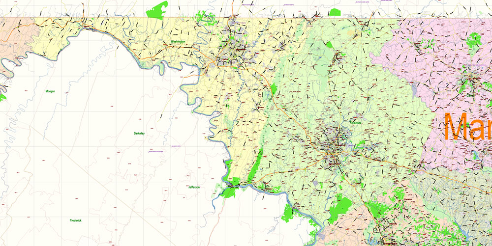
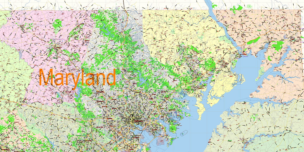
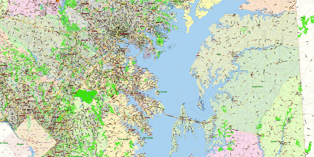
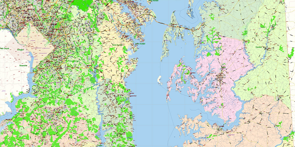
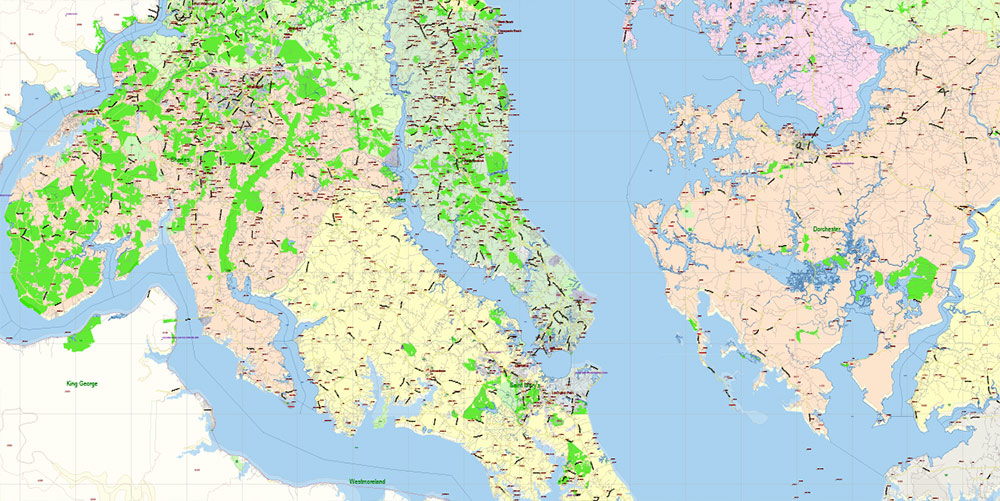
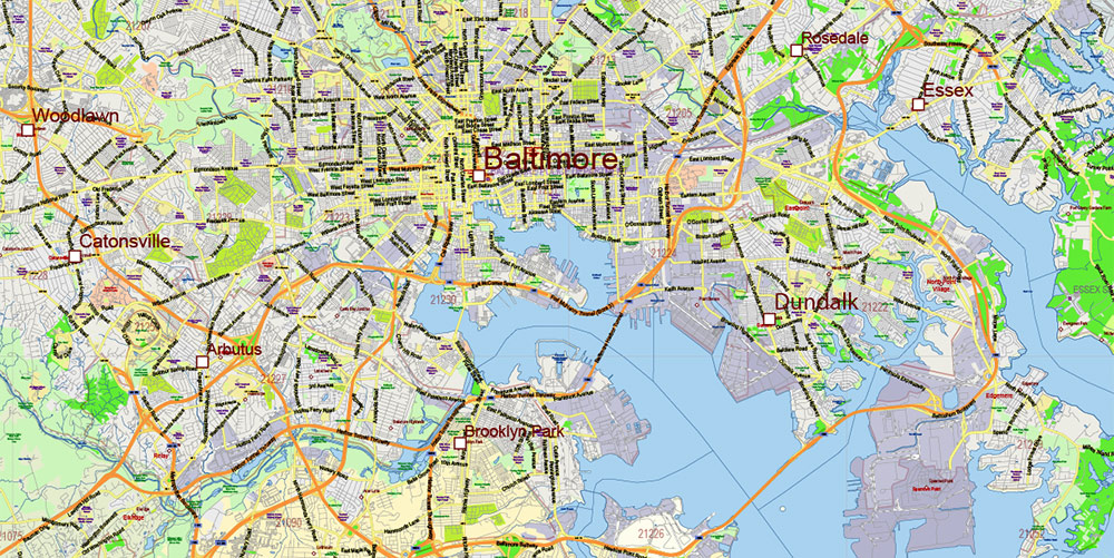
Printable PDF Vector Map of Maryland State Extended Version – US Extra High detailed State Plan scale 1:58526 full editable Adobe PDF Roads + Counties + ZipCodes Map in layers, scalable, text format all names, 176 MB ZIP
Principal street names, ALL STREETS AND ROADS, Main Objects, Counties, Zipcodes, addon layers – Cities / towns by population categories by layers. Map for design, printing, arts, projects, presentations, for architects, designers, and builders, business, logistics.
Included: Simple map of Maryland state.
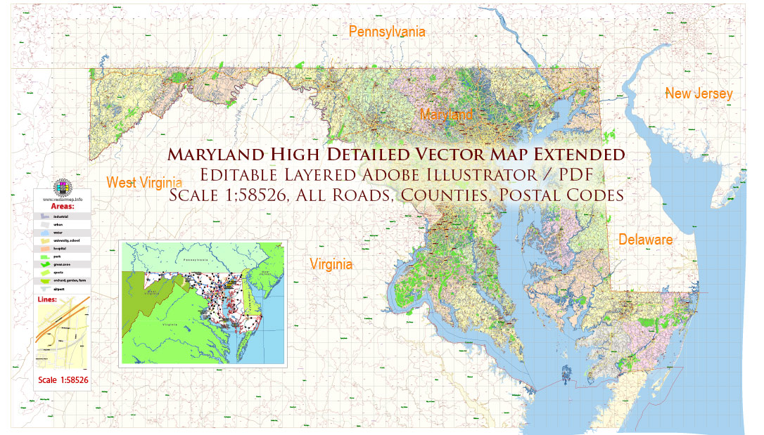
Maryland State US Map PDF Vector Extended Exact High Detailed Street Road Map + Counties + Zipcodes editable Adobe PDF in layers
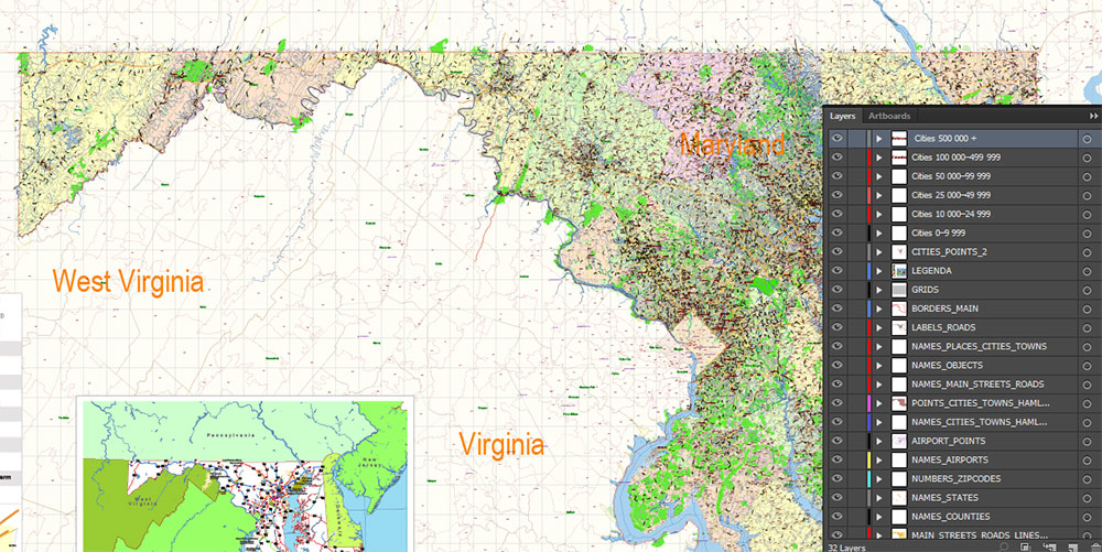
Layers list Maryland State Roads Admin map:
- Legend
- Grids
- Labels of roads
- Addon layers – Cities by population categories + addon points
- Points of airports
- Names of airports
- Names of places (city, hamlet, etc.)
- Names of cities, towns, hamlets 2
- Names of objects (hospitals, schools, parks, water)
- Points of cities, towns, hamlets
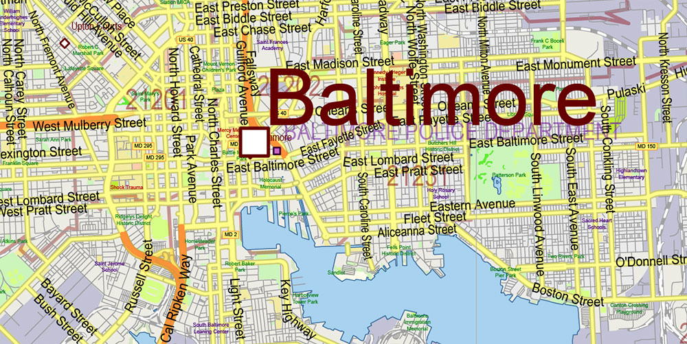
- Names of Main streets
- Main Streets, roads.
- Civil streets
- Railroads
- Waterways (lines)
- Water objects (rivers, lakes, ponds) areas
- Names of Counties
- Names of States
- Zipcodes areas
- Zipcodes numbers
- Counties areas
- States areas
- Color fills (parks, hospital areas, school areas, etc.)
- Background and sea
The most exact and detailed map of the State of Maryland in scale.
ALSO: DWG, DXF, CDR and other formats: free convert for our customers.
For Editing and High-Quality Printing
Maryland – Tactical AO Brief
1. AO OVERVIEW
-
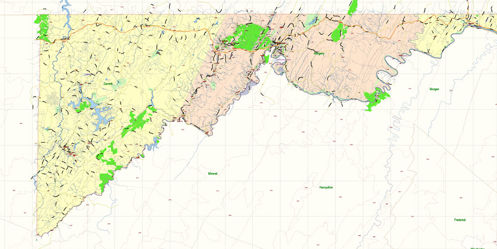
Shape & position: Small, irregular state wrapping around the north side of Washington, D.C., bridging the U.S. Northeast and Mid-Atlantic. Extends from Atlantic coastal plain through rolling Piedmont to the Appalachian ridges in the west.
-
Strategic role:
-
Land bridge between Northeast megalopolis (NY–Philadelphia) and the South via I-95 and major rail.
-
Controls key access to Chesapeake Bay, a major maritime corridor.
-
Shares borders with DC, Virginia, West Virginia, Pennsylvania, and Delaware – dense boundary contact.
-
Key zones:
-
Central urban belt: Baltimore–Washington corridor, dense, high-value targets and logistics.
-
Eastern Shore: Low, flat, agricultural, water-cut, limited major bridges.
-
Western MD: Narrow mountainous corridor – classic chokepoint terrain.
2. KEY TERRAIN & REGIONS
-
Eastern Shore (east of Chesapeake Bay):
-
Very low relief, agriculture and wetlands.
-
Sparse settlements; long, exposed road stretches; limited crossings to main Maryland body via Bay Bridge (US-50/301).
-
Central Piedmont (Baltimore–Washington axis):
-
Rolling hills, dense suburbs, multiple small river valleys.
-
Heavily built-up; complex urban terrain; high civilian presence.
-
Western Maryland (Appalachians):
-
Ridges and narrow valleys (Allegheny, Blue Ridge).
-
Corridor funnels along I-70 / I-68 and rail lines – decisive avenues of approach and ambush points.
Key terrain features:
-
Chesapeake Bay: Dominant water body, massive estuary bisecting the state.
-
Appalachian ridges: Natural defensive lines and observation heights.
-
Fall Line zone (around Baltimore–DC): Transition from hard rock to coastal plain; many crossings and urban nodes located here.
3. LINES OF COMMUNICATION (ROUTES)
Primary MSRs (Main Supply Routes)
Key ASRs (Alternative / Secondary Routes)
-
US-50 / US-301:
-
East–west from DC area across the Chesapeake Bay Bridge to Eastern Shore and Ocean City.
-
Bay Bridge is a critical, fragile node – single major crossing for that sector.
-
US-40 (historic National Road):
-
Numerous state routes (e.g., MD-295 Baltimore–Washington Parkway, MD-32, MD-97) braid the central urban/suburban AO, enabling maneuver but also creating congestion and complexity.
4. URBAN AREAS & HUMAN TERRAIN
Major Urban Nodes
-
Baltimore:
-
Largest city; port and industrial hub on Patapsco River / upper Chesapeake.
-
Intense urban density, mixed high-rise and rowhouse districts, significant socio-economic contrasts.
-
Key assets: Port facilities, rail yards, interstates, hospitals, universities, port-adjacent industry.
-
Washington Suburbs (Maryland side):
-
Silver Spring, Bethesda, Rockville, Gaithersburg, College Park, Greenbelt, Bowie and others.
-
High income, highly educated population; many federal agencies, contractors, and tech/biotech facilities.
-
Very dense transport and communication web.
-
Frederick:
-
Mid-sized city at crossroads of I-70 and I-270; gateway to western MD.
-
Mix of historic core and modern sprawl, close to military and federal installations.
-
Hagerstown:
-
Salisbury & Eastern Shore towns (e.g., Easton, Cambridge):
Demography & Human Terrain
5. HYDROGRAPHY & WATER RESOURCES
6. TRANSPORTATION & INFRASTRUCTURE
-
Ports:
-
Air:
-
Baltimore/Washington International (BWI): Primary commercial and cargo hub between Baltimore and DC.
-
Secondary regional airports near Hagerstown, Salisbury, etc.
-
Numerous smaller airfields and heliports supporting general aviation, medevac, and government activity.
-
Rail:
-
Amtrak Northeast Corridor passes through Baltimore and DC, tunneled and bridged in multiple locations – critical for high-speed passenger movement.
-
MARC commuter rail links Baltimore, DC, and outer suburbs.
-
Freight rail (CSX, Norfolk Southern) corridors parallel major highways and rivers; many yards around Baltimore, Hagerstown, and central MD.
-
Transit:
-
Local transit systems in Baltimore (light rail, subway, buses) and extensive bus/metro networks tied into the DC region.
-
High reliance on private vehicles; highways frequently congested – especially around Baltimore and DC at peak hours.
-
Energy & comms:
-
Dense grid of substations, transmission lines, and telecom hubs in central corridor.
-
Coastal wind, solar, and some legacy industrial sites scattered across the state.
7. CLIMATE & WEATHER
-
Type: Humid continental / subtropical transition.
-
Winters: Cool to cold; snow and ice events possible, especially inland and in western mountains.
-
Summers: Hot, humid, frequent thunderstorms; heat stress likely in urban operations.
-
Storm threats:
-
Remnants of Atlantic hurricanes and tropical storms can bring heavy rain, coastal flooding along the Chesapeake and low-lying areas.
-
Fog along rivers and Bay can degrade visibility and air/sea ops.
8. KEY INSTALLATIONS & NODES (HIGH INTEREST)
(Not exhaustive, focus on types rather than naming every facility.)
-
Military & federal:
-
Army, NSA, and other federal installations in and around central Maryland and the DC border.
-
Numerous research labs, intelligence sites, and secure communications nodes.
-
Industrial:
-
Port-adjacent heavy industry, fuel terminals, and chemical facilities near Baltimore.
-
Distribution warehouses along I-95, I-70, and I-81 corridors.
-
Civil infrastructure:
-
Chesapeake Bay Bridge, major Potomac bridges, rail tunnels/bridges around Baltimore and DC, major power plants and substations.
9. RISKS, HAZARDS, AND CONSTRAINTS
-
Urban density:
-
Collateral damage risk extremely high in Baltimore–DC corridor.
-
Complex vertical and subterranean terrain (tunnels, subways, parking structures).
-
Chokepoints:
-
Limited major crossings over the Chesapeake Bay, Potomac, and Susquehanna – easy to disrupt, hard to replace.
-
Western Maryland corridor narrowed by terrain; few alternate routes.
-
Environmental:
-
Civil considerations:
-
High concentration of politically sensitive sites, media, and federal institutions.
-
Operations will be under intense domestic and international scrutiny.
10. COMMAND TAKEAWAYS
-
Control the corridors: I-95, I-270–I-70–I-68, and US-50/301 plus associated rail lines form the skeleton of movement; losing them fractures operational reach.
-
Respect the water: Chesapeake Bay and its rivers are both barrier and avenue. Bridge nodes are decisive; amphibious and small-craft capability is a major force multiplier.
-
Urban dominance is key: Baltimore and the DC-adjacent suburbs contain most of the state’s population, infrastructure, and strategic targets. Expect dense, complex, politically constrained operations.
-
Use the high ground: Western ridges and central uplands provide observation and control over MSRs; ideal for sensors, comms, and overwatch.
-
Civil–military dynamics: Expect highly capable local authorities, strong law enforcement, and a well-connected population. Information ops and precision in targeting are non-optional.
Maryland State US Map PDF Vector Extended Exact High Detailed Street Road Map + Counties + Zipcodes editable Adobe PDF in layers
Maryland State US Map PDF Vector Extended Exact High Detailed Street Road Map + Counties + Zipcodes editable Adobe PDF in layers
Maryland State US Map PDF Vector Extended Exact High Detailed Street Road Map + Counties + Zipcodes editable Adobe PDF in layers
Maryland State US Map PDF Vector Extended Exact High Detailed Street Road Map + Counties + Zipcodes editable Adobe PDF in layers
Maryland State US Map PDF Vector Extended Exact High Detailed Street Road Map + Counties + Zipcodes editable Adobe PDF in layers
Maryland State US Map PDF Vector Extended Exact High Detailed Street Road Map + Counties + Zipcodes editable Adobe PDF in layers
Maryland State US Map PDF Vector Extended Exact High Detailed Street Road Map + Counties + Zipcodes editable Adobe PDF in layers
Maryland State US Map PDF Vector Extended Exact High Detailed Street Road Map + Counties + Zipcodes editable Adobe PDF in layers
Maryland State US Map PDF Vector Extended Exact High Detailed Street Road Map + Counties + Zipcodes editable Adobe PDF in layers

 Author: Kirill Shrayber, Ph.D. FRGS


 Street Map editable Adobe Illustrator in layers")