Editable Vector Map of the Turku Finland in SVG format.
Can be edited in the following programs: Adobe Illustrator, CorelDraw, InkScape
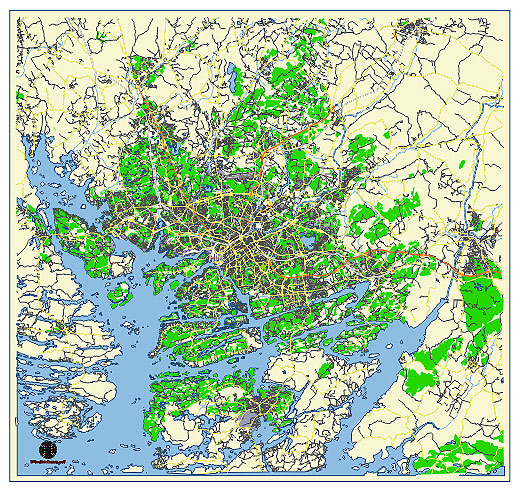
Principal streets and roads, names places, residential streets and roads, road number labels, water objects, land use areas.
Turku Finland editable vector map svg free
DOWNLOAD ARCHIVE FOR FREE >>>
Distributed with Creative Commons CC-Zero = Creative Commons CC0 1.0 Universal Public Domain Dedication International License
SEE ALSO FULL VERSION OF THE Turku Finland vector map (Adobe Illustrator, PDF etc.)
Turku, Finland, is a historic city with a well-planned urban structure. Here are some of the principal streets, roads, and city districts in Turku:
Principal Streets and Roads:
- Aurakatu: A central street in Turku that runs from the Aura River, past the Market Square (Kauppatori), and is lined with various shops, cafes, and historic buildings.
- Hämeenkatu: This street extends from the Turku Market Square towards the eastern part of the city, leading to the district of Varissuo.
- Eerikinkatu: Runs parallel to Aurakatu and is one of the major streets in the city center, known for its shops, restaurants, and cultural institutions.
- Yliopistonkatu: A pedestrian-friendly street in the heart of Turku, known for its vibrant atmosphere and numerous retail establishments.
- Itäinen Rantakatu & Läntinen Rantakatu: These streets run along the eastern and western banks of the Aura River, respectively, offering scenic views and access to many of Turku’s attractions, including the Turku Castle.
- Martinkatu: Located in the Martin district, this street is known for its residential character and local amenities.
- Kaskenkatu: Extends from the city center to the eastern suburbs, passing through residential and commercial areas.
- Puistokatu: A beautiful tree-lined street that adds to the scenic charm of Turku, often leading to parks and green areas.
- Satakunnantie: One of the main arterial roads that connects Turku to the northern parts of the region, important for both local and regional traffic.
Principal City Districts:
- Keskusta (City Center): The commercial and cultural heart of Turku, containing major landmarks such as the Turku Cathedral, Market Square, and several shopping centers.
- Port Arthur (Portsa): A historic residential district known for its wooden houses and quaint, picturesque streets.
- Martti: A primarily residential area located south of the city center, characterized by its peaceful atmosphere and proximity to the Aura River.
- Varissuo: A diverse and multicultural district to the east of the city center, known for its high-rise apartment buildings.
- Runosmäki: A residential suburb located in the northern part of Turku, known for its family-friendly environment and green spaces.
- Hirvensalo: An island district connected to the mainland by bridges, offering a mix of residential areas and natural landscapes.
- Kärsämäki: A district in the northwestern part of Turku, characterized by a mix of residential and industrial zones.
- Nummi: Located near the Turku University campus, this area is popular with students and academic staff.
- Kupittaa: Known for its large park (Kupittaa Park), sports facilities, and the presence of many tech companies and startups.
- Raunistula: A historical residential area to the northwest of the city center, known for its old wooden houses and a unique local community.
These streets, roads, and districts collectively define the urban landscape of Turku, offering a blend of historical charm and modern amenities.
 Author: Kirill Shrayber, Ph.D. FRGS