Editable Vector Map of the Quebec City Canada in SVG format.
Can be edited in the following programs: Adobe Illustrator, CorelDraw, InkScape
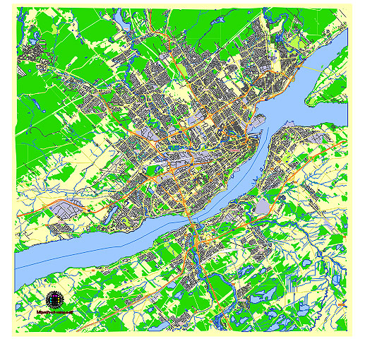
Principal streets and roads, names places, residential streets and roads, road number labels, water objects, land use areas.
Quebec City Canada vector map svg free
DOWNLOAD ARCHIVE FOR FREE >>>
Distributed with Creative Commons CC-Zero = Creative Commons CC0 1.0 Universal Public Domain Dedication International License
SEE ALSO FULL VERSION OF THE Quebec City Canada vector map (Adobe Illustrator, PDF etc.)
Quebec City, the capital of the province of Quebec, Canada, is known for its rich history, charming architecture, and vibrant culture. Here are some of the principal streets, roads, and city districts of Quebec City:
Principal Streets and Roads
- Grande Allée:
- A major thoroughfare that runs from the city center to the suburbs. Known for its lively atmosphere, restaurants, bars, and historical buildings.
- Rue Saint-Jean:
- A bustling street that runs through the Old Quebec district, filled with shops, cafes, and historical sites.
- Boulevard Laurier:
- A key commercial road in the Sainte-Foy–Sillery–Cap-Rouge borough, home to many businesses, shopping centers, and restaurants.
- Avenue Cartier:
- A trendy street in the Montcalm district, known for its artistic vibe, boutiques, and dining options.
- Boulevard Champlain:
- A scenic road running along the St. Lawrence River, offering beautiful views and access to several parks and attractions.
City Districts
- Old Quebec (Vieux-Québec):
- A UNESCO World Heritage site, this district is divided into Upper Town (Haute-Ville) and Lower Town (Basse-Ville), featuring historic landmarks like Château Frontenac, the Citadel, and Place Royale.
- Saint-Roch:
- An up-and-coming area known for its tech start-ups, arts scene, and vibrant nightlife, with many cafes, bars, and boutiques.
- Montcalm:
- Often referred to as the “artistic” district, home to the Quebec National Museum of Fine Arts and several theaters, as well as Avenue Cartier.
- Sainte-Foy–Sillery–Cap-Rouge:
- A large borough that includes residential areas, shopping centers like Place Sainte-Foy and Laurier Quebec, and the Laval University campus.
- Limoilou:
- A district known for its charming residential neighborhoods, green spaces, and a growing number of trendy restaurants and shops.
- Beauport:
- A suburban district to the northeast, offering a mix of residential areas and natural attractions like Montmorency Falls.
These streets and districts highlight the diverse and dynamic nature of Quebec City, each contributing to the city’s unique charm and appeal.
 Author: Kirill Shrayber, Ph.D. FRGS