Editable Vector Map of the Portland Maine US in SVG format.
Can be edited in the following programs: Adobe Illustrator, CorelDraw, InkScape
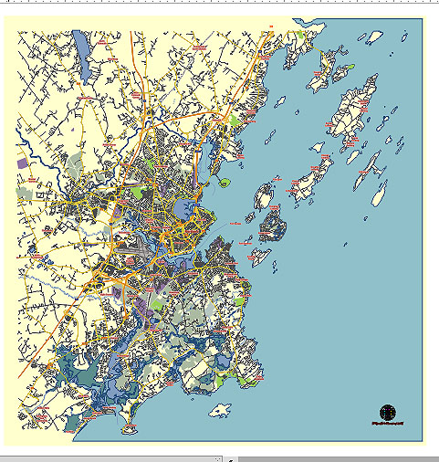
Principal streets and roads, names places, residential streets and roads, road number labels, water objects, land use areas.
Portland Maine US vector map svg free
DOWNLOAD ARCHIVE FOR FREE >>>
Distributed with Creative Commons CC-Zero = Creative Commons CC0 1.0 Universal Public Domain Dedication International License
SEE ALSO FULL VERSION OF THE Portland Maine US vector map (Adobe Illustrator, PDF etc.)
Portland, Maine, is a vibrant city known for its historic charm, beautiful coastal views, and lively cultural scene. Here are some of the principal streets, roads, and city districts of Portland:
Principal Streets and Roads
- Congress Street:
- Description: Congress Street is the main thoroughfare running east to west through downtown Portland. It’s known for its mix of historic architecture, shops, restaurants, and cultural institutions like the Portland Museum of Art.
- Commercial Street:
- Description: Running along the waterfront, Commercial Street is a bustling area with seafood restaurants, shops, and the working waterfront. It’s a great place to see fishing boats and enjoy fresh seafood.
- Fore Street:
- Description: Parallel to Commercial Street, Fore Street offers a mix of upscale restaurants, boutiques, and historic buildings. It’s part of the Old Port district and known for its cobblestone streets.
- High Street:
- Description: High Street runs north-south and connects various neighborhoods. It passes through the Arts District and near the West End, offering access to many cultural and residential areas.
- Deering Avenue:
- Description: This street runs through the Deering Center neighborhood and is home to several schools, parks, and residential areas. It connects to Forest Avenue and Brighton Avenue.
- Forest Avenue:
- Description: Forest Avenue is a major north-south artery that starts near downtown and runs out to the suburbs. It’s lined with businesses, restaurants, and educational institutions like the University of Southern Maine.
City Districts
- Old Port:
- Description: The Old Port is the historic heart of Portland, known for its 19th-century brick buildings, cobblestone streets, and vibrant nightlife. It’s a hub for dining, shopping, and entertainment.
- Arts District:
- Description: Centered around Congress Street, the Arts District is home to a variety of galleries, theaters, and museums, including the Portland Museum of Art and the Maine College of Art.
- West End:
- Description: This residential neighborhood is known for its historic homes, tree-lined streets, and beautiful views of the Western Promenade. It’s a quieter area with a strong sense of community.
- East End:
- Description: Located on the eastern side of the peninsula, the East End includes the Eastern Promenade, a popular park with stunning views of Casco Bay. The neighborhood is a mix of residential areas and recreational spaces.
- Munjoy Hill:
- Description: A part of the East End, Munjoy Hill is a rapidly gentrifying neighborhood with a mix of old and new homes, offering some of the best views in the city. It’s a popular spot for young professionals and families.
- Bayside:
- Description: An area in transition, Bayside is seeing significant redevelopment. It’s known for its industrial past and is now becoming a hub for new businesses, housing, and public services.
- Deering Center:
- Description: A residential district located further from the downtown peninsula, Deering Center features family-friendly neighborhoods, parks, and schools, offering a suburban feel within the city.
- Rosemont:
- Description: Another residential neighborhood, Rosemont is known for its small-town feel, local markets, and easy access to downtown Portland.
Each of these streets and districts contributes to the unique character and charm of Portland, making it a diverse and dynamic city to explore.
 Author: Kirill Shrayber, Ph.D. FRGS