Editable Vector Map of the Phoenix Arizona US in SVG format.
Can be edited in the following programs: Adobe Illustrator, CorelDraw, InkScape
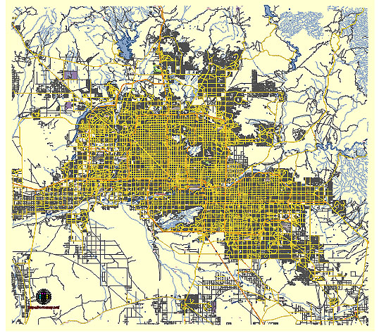
Principal streets and roads, names places, residential streets and roads, road number labels, water objects, land use areas.
Phoenix Arizona US vector map svg free
DOWNLOAD ARCHIVE FOR FREE >>>
Distributed with Creative Commons CC-Zero = Creative Commons CC0 1.0 Universal Public Domain Dedication International License
SEE ALSO FULL VERSION OF THE Phoenix Arizona US vector map (Adobe Illustrator, PDF etc.)
Phoenix, Arizona, is a sprawling city with a well-defined network of streets, roads, and districts. Here are some of the principal streets, roads, and city districts:
Principal Streets and Roads
- Central Avenue: This is one of the main north-south thoroughfares running through the heart of downtown Phoenix. It is known for its skyscrapers and historic buildings.
- Camelback Road: A major east-west road that runs through some of the city’s most affluent areas, including the Biltmore district.
- Van Buren Street: Another significant east-west road that stretches through downtown and beyond, known for its historical significance.
- Indian School Road: This road runs east-west and crosses the city, passing through several key neighborhoods and commercial areas.
- McDowell Road: An important east-west road that runs parallel to Indian School Road, passing through various neighborhoods and commercial zones.
- Thomas Road: Another major east-west road that traverses the city, connecting various residential and commercial districts.
- Bethany Home Road: An east-west road that cuts through several neighborhoods and connects with other major streets.
- Baseline Road: Located in the southern part of Phoenix, this road runs east-west and is a key thoroughfare for the southern neighborhoods.
- Bell Road: This road runs east-west in the northern part of Phoenix and is known for its shopping and dining options.
- Loop 101 (Pima Freeway): A major freeway that loops around the northern and eastern parts of the city, providing critical connectivity to various suburbs.
- I-10 (Papago Freeway): One of the primary interstate highways running east-west through Phoenix, connecting the city to Los Angeles and Tucson.
- I-17 (Black Canyon Freeway): A north-south interstate that runs through Phoenix, connecting it to Flagstaff and northern Arizona.
City Districts
- Downtown Phoenix: The central business district known for its high-rise buildings, cultural institutions, sports arenas, and government offices.
- Midtown Phoenix: Just north of downtown, this area is known for its mix of residential and commercial properties, along with cultural sites like the Heard Museum.
- Arcadia: A well-known, upscale neighborhood in the eastern part of the city, characterized by its large lots and citrus groves.
- Biltmore District: Located near 24th Street and Camelback Road, this area is known for luxury homes, high-end shopping, and the Arizona Biltmore Hotel.
- Encanto Village: Encompassing several neighborhoods including Encanto-Palmcroft, known for its historic homes and the Encanto Park.
- Ahwatukee Foothills: A largely residential area in the southern part of Phoenix, separated from the rest of the city by South Mountain.
- Maryvale: A district in western Phoenix known for its diverse population and suburban character.
- Desert Ridge: A newer, upscale neighborhood in the northeastern part of Phoenix, known for its shopping centers and golf courses.
- South Mountain Village: Located at the base of South Mountain, this district is known for its outdoor recreational opportunities and diverse communities.
- Roosevelt Row: A vibrant arts district in downtown Phoenix known for its galleries, murals, and First Friday Art Walks.
These streets, roads, and districts form the backbone of Phoenix, offering a mix of commercial, residential, and cultural experiences.
 Author: Kirill Shrayber, Ph.D. FRGS