Editable Vector Map of the Orlando Florida US in SVG format.
Can be edited in the following programs: Adobe Illustrator, CorelDraw, InkScape
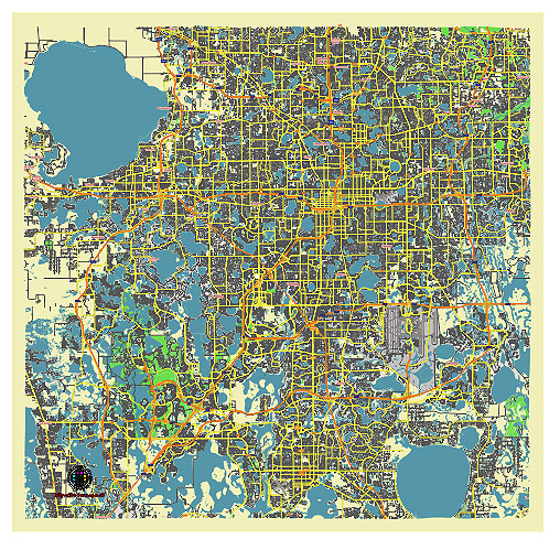
Principal streets and roads, names places, residential streets and roads, road number labels, water objects, land use areas.
Orlando Florida US vector map svg free
DOWNLOAD ARCHIVE FOR FREE >>>
Distributed with Creative Commons CC-Zero = Creative Commons CC0 1.0 Universal Public Domain Dedication International License
SEE ALSO FULL VERSION OF THE Orlando Florida US vector map (Adobe Illustrator, PDF etc.)
Orlando, Florida, is known for its extensive network of streets, roads, and distinct city districts. Here’s an overview:
Principal Streets and Roads
- International Drive (I-Drive):
- A major thoroughfare and tourist hotspot lined with hotels, restaurants, shops, and entertainment venues. It’s home to attractions like ICON Park, the Orlando Eye, and the Orange County Convention Center.
- Orange Blossom Trail (US 441):
- A significant north-south road that runs through the heart of Orlando, connecting various neighborhoods and commercial areas.
- Colonial Drive (State Road 50):
- An east-west route that passes through downtown Orlando and extends to the eastern and western suburbs. It’s a key commercial corridor.
- John Young Parkway:
- A major north-south road that provides access to residential areas, shopping centers, and business districts.
- Semoran Boulevard (State Road 436):
- This road serves the eastern part of Orlando, including the Orlando International Airport area, and connects to several important highways.
- Sand Lake Road:
- A key road that intersects with International Drive and provides access to upscale shopping areas like the Dr. Phillips neighborhood.
- Lake Underhill Road:
- Runs east-west through residential areas and provides access to recreational spaces like Lake Underhill Park.
- Alafaya Trail:
- Located in the eastern part of Orlando, near the University of Central Florida (UCF), it serves a rapidly growing suburban area.
City Districts
- Downtown Orlando:
- The central business district, known for its high-rise buildings, corporate offices, cultural venues like the Dr. Phillips Center for the Performing Arts, and sports facilities like the Amway Center. It’s also home to Lake Eola Park.
- Thornton Park:
- A trendy neighborhood adjacent to downtown, known for its brick-lined streets, charming bungalows, and vibrant dining and nightlife scene.
- Parramore:
- An historic African-American neighborhood west of downtown, undergoing significant revitalization efforts, with new housing, community centers, and the Orlando City Soccer Stadium.
- Lake Nona:
- A rapidly developing area in southeast Orlando known for its focus on technology and innovation, featuring the Medical City complex, USTA National Campus, and various residential communities.
- College Park:
- A residential neighborhood north of downtown, known for its charming streets named after Ivy League colleges, trendy shops, restaurants, and local parks.
- Baldwin Park:
- A master-planned community built on the former site of a naval training center, featuring modern homes, parks, lakes, and a lively town center.
- Dr. Phillips:
- An affluent area west of downtown, known for its upscale homes, excellent schools, and the popular Restaurant Row on Sand Lake Road.
- Audubon Park Garden District:
- An eclectic and vibrant community known for its focus on sustainability, local businesses, and the East End Market, a hub for artisanal foods and crafts.
- Millenia:
- A commercial district centered around The Mall at Millenia, a high-end shopping destination with luxury retailers and dining options.
- Winter Park:
- Although technically a separate city, Winter Park is often associated with Orlando. It’s known for its tree-lined streets, upscale homes, Rollins College, and the scenic Park Avenue shopping district.
These principal streets, roads, and city districts give Orlando its unique character, blending residential, commercial, and entertainment spaces.
 Author: Kirill Shrayber, Ph.D. FRGS