Editable Vector Map of the New Braunfels Texas US in SVG format.
Can be edited in the following programs: Adobe Illustrator, CorelDraw, InkScape
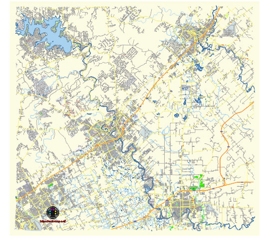
Principal streets and roads, names places, residential streets and roads, road number labels, water objects, land use areas.
New Braunfels Texas US vector map svg free
DOWNLOAD ARCHIVE FOR FREE >>>
Distributed with Creative Commons Attribution 4.0 International License
SEE ALSO FULL VERSION OF THE New Braunfels Texas US vector map (Adobe Illustrator, PDF etc.)
New Braunfels, Texas, is a city known for its German heritage, natural beauty, and vibrant community. Here are some of the principal streets, roads, and city districts in New Braunfels:
Principal Streets and Roads
- Interstate 35 (I-35): This major highway runs through New Braunfels, connecting it to San Antonio to the southwest and Austin to the northeast.
- State Highway 46 (SH-46): This highway runs east-west through New Braunfels, connecting the city to Boerne and Seguin.
- Loop 337: This loop road circles much of the city, providing access to various neighborhoods and commercial areas.
- Common Street: Runs through the downtown area and is home to many businesses and historic sites.
- Walnut Avenue: Another important thoroughfare that connects residential areas with commercial zones.
- Landa Street: Leads to Landa Park, one of the city’s major attractions.
- Seguin Avenue: A key street in downtown New Braunfels, lined with shops, restaurants, and cultural sites.
- San Antonio Street: Another main street in the heart of the city, featuring various local businesses and historic buildings.
- Gruene Road: Leads to the Gruene Historic District, known for its historic dance hall and charming shops.
- FM 306: Connects New Braunfels to Canyon Lake, a popular recreational area.
City Districts
- Downtown New Braunfels: The historic heart of the city, featuring a variety of shops, restaurants, and historic sites. The Comal County Courthouse and the Sophienburg Museum are notable landmarks.
- Gruene Historic District: Known for its well-preserved 19th-century buildings, the iconic Gruene Hall (Texas’ oldest dance hall), and various boutique shops and restaurants.
- Landa Park: This district includes the expansive Landa Park, which offers natural attractions, such as springs, walking trails, and a miniature train.
- Town Creek: A modern, mixed-use development near downtown that combines residential, commercial, and recreational spaces.
- River Road: This area is known for its scenic drive along the Guadalupe River, with many opportunities for tubing, camping, and riverside dining.
- Creekside: A commercial district that features the Town Center at Creekside, a large shopping center with retail stores, restaurants, and entertainment options.
- Mission Hills Ranch: A residential neighborhood located on the western side of the city, offering a suburban feel with easy access to the city’s amenities.
- Vintage Oaks: A master-planned community known for its luxurious homes and resort-style amenities, including a clubhouse, pools, and hiking trails.
- Oak Run: Another residential community that offers family-friendly living with parks, schools, and easy access to Loop 337.
- River Chase: A large residential development located near Canyon Lake, known for its spacious lots and country living atmosphere.
These streets, roads, and districts help define the character and layout of New Braunfels, making it a unique and attractive place to live and visit.
 Author: Kirill Shrayber, Ph.D. FRGS