Editable Vector Map of the Minsk Belarus in SVG format.
Can be edited in the following programs: Adobe Illustrator, CorelDraw, InkScape
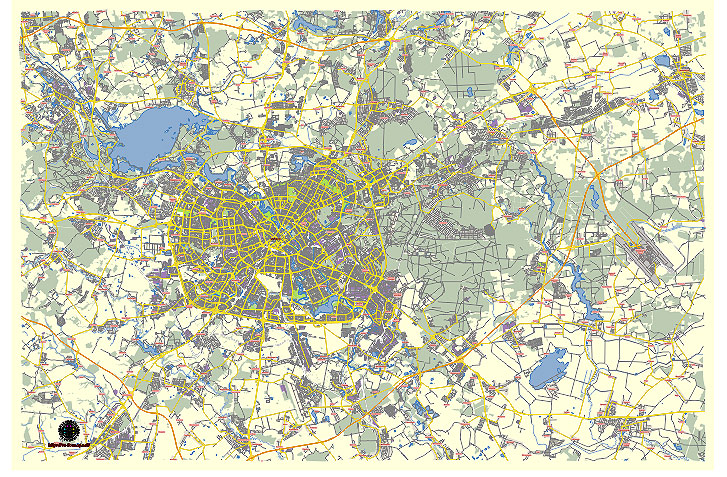
Principal streets and roads, names places, residential streets and roads, road number labels, water objects, land use areas.
Minsk Belarus editable vector map svg free
DOWNLOAD ARCHIVE FOR FREE >>>
Distributed with Creative Commons Attribution 4.0 International License
SEE ALSO FULL VERSION OF THE Minsk Belarus vector map (Adobe Illustrator, PDF etc.)
Minsk, the capital city of Belarus, is a major cultural, economic, and political center in the country. Here is an overview of some of the principal streets, roads, and districts in Minsk:
Principal Streets and Roads
- Independence Avenue (Praspiekt Niezaliežnasci):
- One of the longest and most important streets in Minsk.
- It stretches from the southeastern outskirts of the city to the northwestern part.
- Key landmarks along the avenue include Victory Square, Independence Square, and the Belarusian State Circus.
- Pobediteley Avenue (Praspiekt Pabiedzicieliau):
- Another major thoroughfare in Minsk.
- Known for its modern buildings and the Minsk-Arena complex.
- Connects the city center with the western parts of Minsk.
- Nemiga Street:
- Historic street located near the city center.
- Known for shopping, dining, and nightlife.
- Important for its cultural and historical significance.
- Masherov Avenue:
- Named after Pyotr Masherov, a former leader of Soviet Belarus.
- Major route running through several districts.
- Known for administrative and residential buildings.
- Lenin Street:
- Central street in the city, named after Vladimir Lenin.
- Features historical architecture and several government buildings.
Major City Districts
- Tsentralny District:
- The central district of Minsk.
- Contains many administrative buildings, cultural institutions, and shopping areas.
- Key landmarks: Independence Square, Gorky Park, and the Central Railway Station.
- Sovetsky District:
- Located in the northeastern part of Minsk.
- Home to several educational institutions, including the Belarusian State University.
- Notable for its parks and recreational areas.
- Pervomaisky District:
- Situated in the eastern part of the city.
- Known for its residential neighborhoods and green spaces.
- Important sites include the Botanical Garden and Chelyuskintsev Park.
- Partizansky District:
- Located in the southeastern part of Minsk.
- Named after the partisans of World War II.
- Features a mix of industrial and residential areas.
- Moskovsky District:
- Located in the southwestern part of Minsk.
- Known for its large residential complexes and industrial zones.
- Important landmarks include the Minsk-Arena and Dzerzhinsky Avenue.
- Frunzensky District:
- Western part of the city.
- Known for its residential areas and shopping centers.
- Important sites include Kuntsevshchina and the Minsk Zoo.
- Oktyabrsky District:
- Southern part of Minsk.
- Mix of industrial and residential areas.
- Key landmarks: Chizhovka Arena and the Loshitsky Park.
- Leninsky District:
- Located in the southeastern part of the city.
- Industrial and residential district.
- Known for the Minsk Automobile Plant (MAZ) and the Chervyakova Market.
Key Squares
- Independence Square:
- One of the largest squares in Europe.
- Features the Government House and the Red Church (Church of Saints Simon and Helena).
- Victory Square:
- Central landmark commemorating the victory in the Great Patriotic War.
- Features the Victory Monument and Eternal Flame.
- October Square:
- Located in the city center.
- Home to the Palace of the Republic and the Trade Unions Palace.
These streets, roads, and districts are central to the daily life and historical heritage of Minsk, offering a blend of modern infrastructure and rich cultural history.
 Author: Kirill Shrayber, Ph.D. FRGS