Editable Vector Map of the Louisville Kentucky US in SVG format.
Can be edited in the following programs: Adobe Illustrator, CorelDraw, InkScape
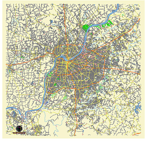
Principal streets and roads, names places, residential streets and roads, road number labels, water objects, land use areas.
Louisville Kentucky US editable vector map svg free
DOWNLOAD ARCHIVE FOR FREE >>>
Distributed with Creative Commons Attribution 4.0 International License
SEE ALSO FULL VERSION OF THE Louisville Kentucky US vector map (Adobe Illustrator, PDF etc.)
Louisville, Kentucky, is known for its diverse and vibrant neighborhoods, as well as its significant streets and roads that connect these areas. Here are some of the principal streets, roads, and city districts in Louisville:
Principal Streets and Roads
- Main Street: A major east-west thoroughfare that runs through downtown Louisville, home to many businesses, restaurants, and cultural attractions.
- Market Street: Another key east-west street parallel to Main Street, featuring many shops, restaurants, and the historic Whiskey Row.
- Broadway: A significant east-west corridor that runs through the city, known for its wide lanes and as a route for major parades and events.
- Bardstown Road: A major artery running through the Highlands neighborhood, known for its eclectic mix of shops, bars, and restaurants.
- Dixie Highway: A major north-south route that extends from downtown Louisville into the southwestern suburbs, serving as a primary commercial strip.
- Shelbyville Road (US 60): A major east-west route that runs through St. Matthews and Middletown, with many shopping centers and businesses.
- Frankfort Avenue: Runs through the Clifton and Crescent Hill neighborhoods, known for its local shops, restaurants, and historic charm.
- Hurstbourne Parkway: A major loop road in the eastern part of the city, connecting various neighborhoods and commercial areas.
- Preston Highway: Runs south from downtown Louisville, serving as a major commercial and transportation corridor.
- River Road: A scenic route that runs along the Ohio River, providing access to parks, recreational areas, and the Louisville Waterfront.
City Districts and Neighborhoods
- Downtown Louisville: The central business district, home to corporate offices, cultural attractions like the Kentucky Center for the Performing Arts, and the KFC Yum! Center.
- Old Louisville: Known for its Victorian-era homes and the historic St. James Court, as well as Central Park.
- The Highlands: A vibrant, eclectic neighborhood centered around Bardstown Road, known for its nightlife, dining, and independent shops.
- Nulu (East Market District): An up-and-coming area known for its galleries, unique shops, and innovative restaurants.
- Germantown: A historic neighborhood with a mix of traditional and modern homes, popular for its breweries and trendy eateries.
- Butchertown: Known for its historic architecture, the Butchertown Market, and the Louisville City FC soccer stadium.
- Clifton: Located along Frankfort Avenue, this neighborhood features a mix of residential and commercial properties, known for its culinary scene.
- Crescent Hill: A family-friendly neighborhood with parks, schools, and the historic Peterson-Dumesnil House.
- St. Matthews: A suburban district with a mix of residential areas, shopping centers, and business parks.
- Middletown: An eastern suburb with a small-town feel, featuring historic buildings and modern developments.
These streets and districts represent some of the key areas that define Louisville’s character and provide a mix of historic charm and modern amenities.
 Author: Kirill Shrayber, Ph.D. FRGS