Editable Vector Map of the Las Vegas Nevada US in SVG format.
Can be edited in the following programs: Adobe Illustrator, CorelDraw, InkScape
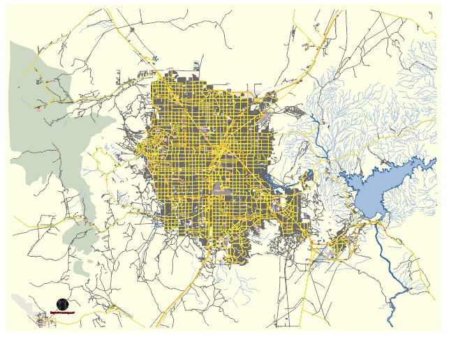
Principal streets and roads, names places, residential streets and roads, road number labels, water objects, land use areas.
Las Vegas Nevada US editable vector map svg free
DOWNLOAD ARCHIVE FOR FREE >>>
Distributed with Creative Commons Attribution 4.0 International License
SEE ALSO FULL VERSION OF THE Las Vegas Nevada US vector map (Adobe Illustrator, PDF etc.)
Las Vegas, Nevada, is a city known for its vibrant nightlife, entertainment, and gambling. Here are some of the principal streets, roads, and city districts in Las Vegas:
Principal Streets and Roads
- Las Vegas Boulevard (The Strip):
- The most famous street in Las Vegas, known for its concentration of large hotel-casino complexes. Major landmarks include the Bellagio, MGM Grand, Caesars Palace, and the Stratosphere Tower.
- Fremont Street:
- Located in downtown Las Vegas, this street is famous for its historic casinos and the Fremont Street Experience, a pedestrian mall and light show.
- Spring Mountain Road:
- Known for its diverse range of Asian businesses and restaurants, it runs parallel to The Strip.
- Tropicana Avenue:
- A major east-west road that crosses The Strip and is home to the Tropicana Las Vegas and other notable properties.
- Sahara Avenue:
- Another significant east-west road, crossing The Strip near the Sahara Las Vegas Hotel and Casino.
- Charleston Boulevard:
- This road runs through the Arts District and provides access to many cultural and historic sites in the city.
- Flamingo Road:
- Crosses The Strip and is home to the Flamingo Las Vegas Hotel and Casino, as well as several other major resorts.
- Desert Inn Road:
- An important road that runs east-west, providing access to many residential and commercial areas.
- Rainbow Boulevard:
- A major north-south road that runs through residential and commercial areas in the western part of the city.
City Districts
- The Strip:
- The central hub of tourism and entertainment in Las Vegas, known for its resorts, casinos, shopping, dining, and nightlife.
- Downtown Las Vegas:
- The historic core of the city, featuring Fremont Street, the Fremont Street Experience, and a mix of classic and new attractions.
- Summerlin:
- A large, affluent residential area located to the west of the city, known for its master-planned communities, parks, and golf courses.
- Henderson:
- A city in the southeastern part of the Las Vegas metropolitan area, known for its residential neighborhoods, parks, and shopping centers.
- North Las Vegas:
- An independent city to the north of Las Vegas, with a mix of residential, industrial, and commercial areas.
- Paradise:
- An unincorporated town that includes much of the Las Vegas Strip and the McCarran International Airport.
- Enterprise:
- Another unincorporated town that includes part of the southwestern suburbs of Las Vegas, featuring a mix of residential and commercial development.
- The Arts District:
- Located just south of downtown, this area is known for its galleries, studios, and cultural events.
- Chinatown:
- Centered around Spring Mountain Road, this area features a variety of Asian markets, restaurants, and businesses.
- Anthem:
- A master-planned community in Henderson, known for its upscale homes and scenic views.
These streets, roads, and districts form the backbone of Las Vegas, each contributing to the city’s unique character and allure.
 Author: Kirill Shrayber, Ph.D. FRGS