Editable Vector Map of the Lahore Pakistan in SVG format.
Can be edited in the following programs: Adobe Illustrator, CorelDraw, InkScape
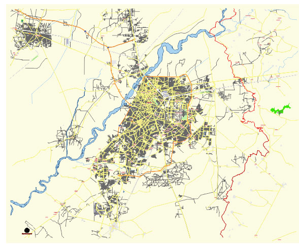
Principal streets and roads, names places, residential streets and roads, road number labels, water objects, land use areas.
Lahore Pakistan editable vector map svg free
DOWNLOAD ARCHIVE FOR FREE >>>
Distributed with Creative Commons Attribution 4.0 International License
SEE ALSO FULL VERSION OF THE Lahore Pakistan vector map (Adobe Illustrator, PDF etc.)
Lahore, the cultural heart of Pakistan, is a city rich in history, architecture, and vibrant neighborhoods. Here’s an overview of its principal streets, roads, and key districts:
Principal Streets and Roads
- Mall Road (Shahrah-e-Quaid-e-Azam): One of the most significant roads in Lahore, lined with historic buildings, government offices, and educational institutions. It connects different parts of the city and is a major commercial hub.
- Ferozepur Road: A major arterial road that runs from the city center to the outskirts, passing through several commercial and residential areas.
- Canal Bank Road: Runs parallel to the Lahore Canal, providing a scenic route through the city. It connects several key neighborhoods and educational institutions.
- Jail Road: A crucial road that connects Gulberg to other parts of the city, known for its educational institutions, hospitals, and commercial areas.
- MM Alam Road: Located in Gulberg, this road is famous for its upscale restaurants, cafes, boutiques, and shopping malls.
- Raiwind Road: Connects Lahore to the suburb of Raiwind, passing through various residential and commercial developments.
- Defence Road: Serves the DHA (Defence Housing Authority) areas, connecting different phases of this upscale residential and commercial area.
- Ring Road: Encircles the city, providing a bypass for traffic and connecting major highways and suburbs.
- Allama Iqbal Road: A key road in the Garhi Shahu area, connecting several important neighborhoods.
- GT Road (Grand Trunk Road): One of the oldest and longest roads in the region, it connects Lahore to other major cities in Pakistan and India.
Key Districts
- Gulberg: A major commercial and residential area, known for its shopping centers, restaurants, and educational institutions. It includes popular spots like Liberty Market and MM Alam Road.
- Defence (DHA): An upscale residential and commercial area known for its modern infrastructure, shopping malls, and dining options.
- Johar Town: A large residential area with numerous educational institutions, hospitals, and commercial centers.
- Model Town: A planned residential area with parks, educational institutions, and commercial areas.
- Cantt (Cantonment): A posh residential and military area with historical significance, well-maintained parks, and upscale markets.
- Walled City (Androon Shehr): The historic core of Lahore, home to famous landmarks like the Lahore Fort, Badshahi Mosque, and bustling bazaars.
- Garden Town: A residential and commercial district with various educational institutions and healthcare facilities.
- Shadman: A central residential area with commercial zones, known for its accessibility and amenities.
- Iqbal Town: A large residential area with various commercial centers and educational institutions.
- Bahria Town: A modern suburban development with luxurious housing, shopping malls, parks, and recreational facilities.
- Faisal Town: A residential and commercial area known for its markets and accessibility.
- Township: A densely populated residential area with several markets, educational institutions, and healthcare facilities.
- Samanabad: A central residential area with a mix of old and new buildings, markets, and educational institutions.
Notable Landmarks and Areas
- Lahore Fort and Badshahi Mosque: Iconic historical landmarks located in the Walled City.
- Minar-e-Pakistan: A national monument located in Iqbal Park.
- Lahore Museum: A major museum located on Mall Road.
- Shalimar Gardens: Mughal-era gardens located along GT Road.
- Jilani Park (Racecourse Park): A large public park located near Jail Road.
- Liberty Market: A popular shopping destination in Gulberg.
- Fortress Stadium: A commercial area with shopping malls, restaurants, and an amusement park.
Lahore’s road network and districts reflect its historical significance, cultural richness, and modern development, making it a dynamic and diverse city.
 Author: Kirill Shrayber, Ph.D. FRGS