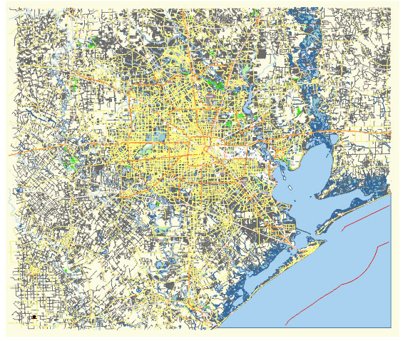
Editable Vector Map of the Houston Texas US in SVG format.
Can be edited in the following programs: Adobe Illustrator, CorelDraw, InkScape
Principal streets and roads, names places, residential streets and roads, road number labels, water objects, land use areas.

DOWNLOAD ARCHIVE FOR FREE >>>
Distributed with Creative Commons Attribution 4.0 International License
SEE ALSO FULL VERSION OF THE Houston Texas US vector map (Adobe Illustrator, PDF etc.)
Houston, Texas, is a sprawling metropolis with a complex network of streets, roads, and distinct city districts. Here are some of the principal streets and roads, along with key city districts:
Principal Streets and Roads
- Interstate 10 (I-10): Runs east-west through Houston, connecting the city to San Antonio to the west and New Orleans to the east.
- Interstate 45 (I-45): Runs north-south, connecting Houston with Dallas to the north and Galveston to the south.
- Interstate 69 (I-69)/U.S. Route 59 (US 59): Another major north-south route, connecting Houston with Victoria to the southwest and Texarkana to the northeast.
- Interstate 610 (I-610): Known as the “610 Loop,” this freeway encircles the central part of Houston and serves as a boundary for various districts.
- Beltway 8 (Sam Houston Tollway): A larger loop around the city, providing a second ring road outside the 610 Loop.
- Highway 290 (Northwest Freeway): Connects Houston to Austin, running northwest from the city.
- Highway 288: Runs south from downtown Houston to the suburbs of Pearland and beyond.
- Westheimer Road: A major east-west thoroughfare running through several key areas, including Uptown and the Galleria.
- Main Street: Runs through the heart of downtown and is known for its historic and cultural significance.
- Katy Freeway: The portion of I-10 west of downtown, leading to the suburb of Katy.
- Memorial Drive: A scenic road running parallel to Buffalo Bayou, connecting downtown with the western suburbs.
Key City Districts
- Downtown: The central business district with skyscrapers, corporate headquarters, and cultural institutions like the Theater District and Discovery Green park.
- Midtown: Known for its vibrant nightlife, restaurants, and proximity to downtown, popular with young professionals.
- Montrose: A diverse, artsy area with a bohemian vibe, known for its galleries, vintage shops, and LGBT-friendly atmosphere.
- The Heights: One of Houston’s oldest neighborhoods, characterized by Victorian homes, a growing food scene, and unique local shops.
- River Oaks: An affluent neighborhood known for its stately mansions and upscale shopping at the River Oaks District.
- Galleria/Uptown: Home to the Galleria mall, a major shopping and business district with high-rise office buildings and hotels.
- Museum District: Concentrated area of museums, including the Houston Museum of Natural Science and the Museum of Fine Arts.
- Medical Center: One of the largest medical complexes in the world, featuring numerous hospitals, research institutions, and the Texas Medical Center.
- EaDo (East Downtown): An up-and-coming area with a focus on arts, entertainment, and sports venues like the BBVA Stadium.
- West University Place: Also known as “West U,” a wealthy enclave with a suburban feel, home to many professionals and families.
- Sugar Land: A suburban city southwest of Houston, known for its master-planned communities and family-friendly amenities.
- The Woodlands: A suburban community north of Houston, famous for its planned neighborhoods, shopping centers, and outdoor spaces.
- Clear Lake: A district southeast of Houston, near NASA’s Johnson Space Center and home to a large waterfront community.
These streets, roads, and districts make up the core structure of Houston, reflecting its diverse character and expansive geography.

 Author: Kirill Shrayber, Ph.D. FRGS