Editable Vector Map of the Albuquerque New Mexico US in SVG format.
Can be edited in the following programs: Adobe Illustrator, CorelDraw, Inkscape
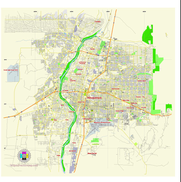
Principal streets and roads, names places, residential streets and roads, road number labels, water objects, landuse areas.
Albuquerque New Mexico US editable vector map svg free
DOWNLOAD ARCHIVE FOR FREE >>>
Distributed with Creative Commons Attribution 4.0 International License
SEE ALSO FULL VERSION OF THE Albuquerque New Mexico US vector map (Adobe Illustrator, PDF etc.)
Albuquerque, the largest city in New Mexico, has a well-organized layout with a variety of principal streets, roads, and distinct city districts. Here’s an overview:
Principal Streets and Roads
- Central Avenue (Route 66): One of the most famous roads in the U.S., Central Avenue runs east-west through Albuquerque and is a historic section of the original Route 66.
- Interstate 25 (I-25): This major north-south interstate runs through the heart of Albuquerque, providing a key transportation route.
- Interstate 40 (I-40): Another major interstate, I-40 runs east-west and intersects with I-25 near the center of the city.
- Coors Boulevard: A major north-south thoroughfare on the west side of the city.
- Paseo del Norte: A significant east-west road that runs through the northern part of Albuquerque, providing access to many residential and commercial areas.
- Montgomery Boulevard: An important east-west arterial road that traverses central Albuquerque.
- San Mateo Boulevard: A busy north-south road that runs through the eastern part of the city.
- Tramway Boulevard: Runs along the foothills of the Sandia Mountains on the eastern edge of Albuquerque, offering scenic views.
City Districts
- Downtown: The central business district with a mix of commercial, residential, and cultural sites, including the Albuquerque Convention Center and Civic Plaza.
- Old Town: The historic heart of the city, known for its adobe buildings, museums, and the San Felipe de Neri Church.
- Nob Hill: Located along Central Avenue, Nob Hill is a vibrant area with eclectic shops, restaurants, and nightlife, characterized by its Route 66 heritage.
- North Valley: A lush, semi-rural area along the Rio Grande, featuring large properties, farms, and the Los Poblanos Historic Inn and Organic Farm.
- Northeast Heights: A primarily residential area with several shopping centers, parks, and the Sandia National Laboratories.
- Westside: A rapidly growing suburban area across the Rio Grande, offering residential neighborhoods, schools, and commercial developments.
- University Area: Surrounding the University of New Mexico, this district is filled with student housing, cafes, and bookstores.
- South Valley: Known for its agricultural roots, this area has a mix of rural landscapes, residential communities, and small businesses.
- Uptown: A commercial and retail hub, featuring the Coronado Center mall, office buildings, and hotels.
- Eastside: Residential neighborhoods nestled along the eastern edge of the city, close to the Sandia Mountains.
These streets and districts collectively contribute to the diverse and dynamic character of Albuquerque, offering a blend of historic charm and modern amenities.
 Author: Kirill Shrayber, Ph.D. FRGS