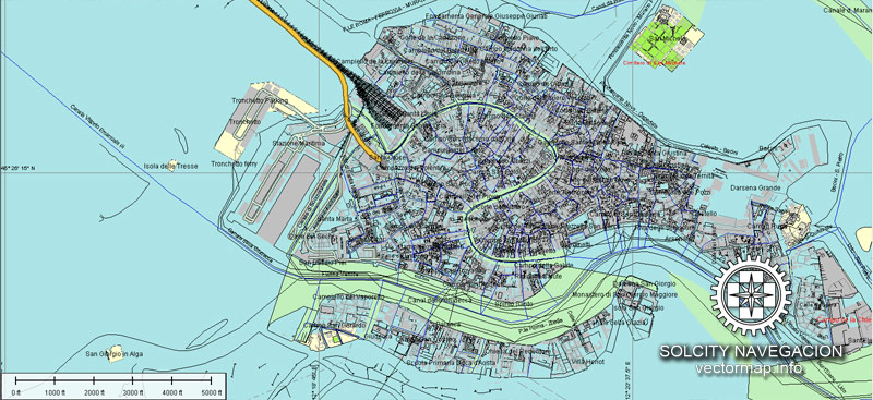
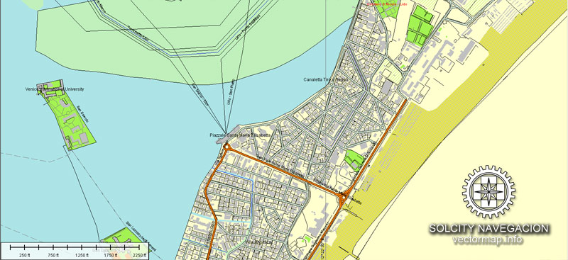
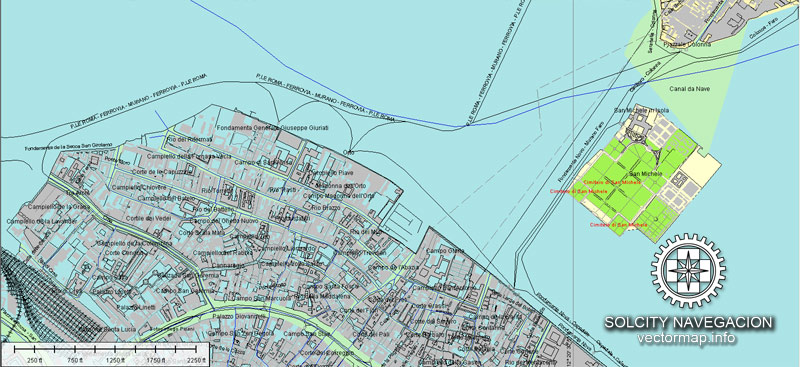
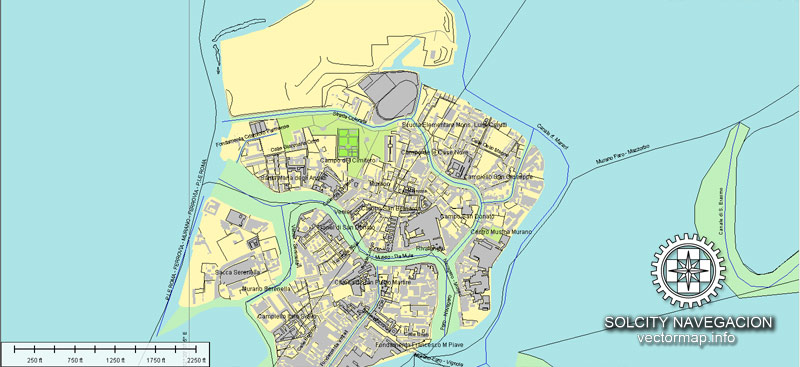
About scalable vectorial city map of Venezia, Italy, Europe
Archive size: 194 Mb, AI zipped
DPI: 300
License: Royalty Free
100 parts atlas
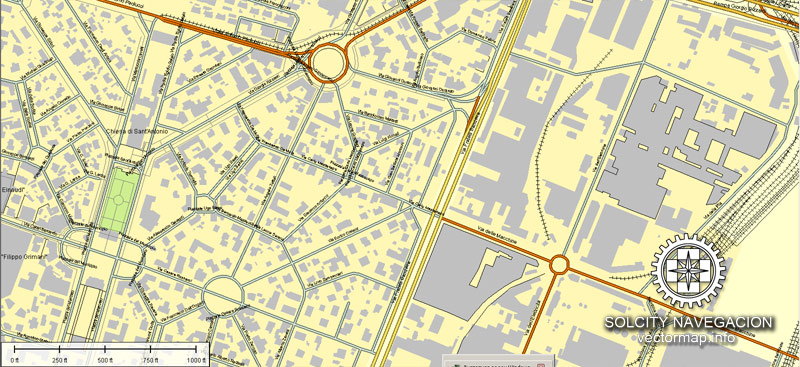
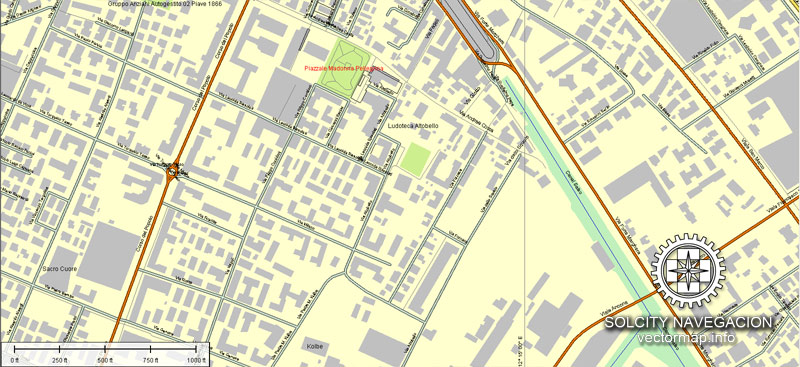
This detailed and layered map of Venezia (Italy) is compatible with all vector formats: Freehand, Corel Draw, AutoCad and other. Fully editable, you can change names, line thickness, colors, filling, fonts or add objects needed.
This Venezia vectorial map features:
Highways with names,
Major streets with names,
Major Roads,
National Park Borders,
Airports,
Railway lines with stops,
Latitude and Longitude data,
Minor Roads,
Private Roads,
Cemeteries,
Big and small Rivers, small streams also,
Lake, ponds and other water bodies,
Landmark fill,
Recreation zones,
County Borders with fill,
Sidewalk/Walkway/Pedestrian roads,
Power Lines,
Parks.
Probably you need more data, or something special? Please, feel free to contact our friendly team.
Venice, Italy.
This vector map of Venice is used as a basis for design, editing, and further printing.
This is the most detailed, exact map of Venice for high-quality printing and polygraphy. You can always clarify the map development date by contacting us.
For your convenience, all objects on Venice vector map are divided into layers. And the editing is very easy – colors, lines, etc.
You can easily add any objects needed (e.g. shops, salons, sale points, gas station or attraction) on any layer of Venice vector map.
Venice is a city in northeastern Italy and the capital of the Veneto region.
It is situated across a group of 118 small islands that are separated by canals and linked by over 400 bridges. The islands are located in the shallow Venetian Lagoon, an enclosed bay that lies between the mouths of the Po and the Piave rivers (more exactly between the Brenta and the Sile). Parts of Venice are renowned for the beauty of their settings, their architecture, and artwork. The lagoon and a part of the city are listed as a UNESCO World Heritage Site.
One of the advantages of Venice vector maps of our production is the relevance of cartographic data, we constantly update all our products.
This vector map of Venice is used by:
designers, layout designers, printers, advertisers and architects. Our product – vector maps – is designed for further editing and printing in large formats – from @Wall format (a few meters) to A-0 and A-1, A-2, A-3.
Venice map in vector format is used for design, urban planning, presentations and media visualizations.
Advertising and presentation map of Venice (usually the final designer marks the routes, and puts the client’s objects (shops, saloons, gas stations etc.)
The undoubted advantage is that people will NEVER throw out this advertising product – the map. In fact, as an advertising medium, a map is the most “long-playing” of the well-known polygraphic advertising media, with the longest lifespan, and the maximum number of interactions with the customer.
For travelers, maps are sold at the airports and gas stations around the world. Often the source is our vector maps.
Take a look, who purchases our vector maps of Venice in “Our Clients and Friends” page – these are large and small companies, from super-brands like Volvo and Starbucks, to small design studios and printing houses.
It’s very easy to work with vector maps of Venice, even for a not very experienced designer who can turn on and off the map layers, add new objects, change the colors of fill and lines according to customer requirements.
The undoubted advantage of Venice vector maps in printing is an excellent and detailed visualization, when customer can expand a large paper map and instantly define his location, find a landmark, an object or address on map, unlike using the popular electronic formats of Google and Yandex maps for example.
Printable vector maps of Venice are much more convenient and efficient than any electronic maps on your smartphone, because ALL DETAILS are displayed in the entire space of Venice map.
Useful tips on working with vector maps of cities and countries in Adobe Illustrator.
«V» – launches the Selection tool (cursor, black arrow), which makes active any vector line.
«А» – launches the Direct Selection tool (white cursor), allows you to select curve elements and drag them to the desired place.
«R» – activates the Rotate tool, which helps you rotating selected objects around the center point by 360 degrees.
«E» – gives you the opportunity to use the Eraser tool and erase unnecessary parts.
«X» – switches between Fill and Stroke in the Tools section. Try to get used to this hot key and
you will quickly understand that you can’t live and work without it.
Guides are not limited to vertical and horizontal in Adobe Illustrator. You can also create a diagonal guide for example. Moreover, you can turn any contours into guides. Select the outline and go to View > Guides > Make Guides (Create Guides), or simply press Cmd/Ctrl + 5. You can also turn the guides back into an editable object. Go to menu, View > Guides > Unlock Guides (Release Guides), select the guide you want to edit and select View > Guides > Release Guides (Reset Guides), or just press Cmd/Ctrl + Option / Alt + 5).
You will probably want to change the color scheme used on our Venice vector map.
To quickly and effectively play with colors.
Of course, you can do it manually, all objects in our Venice vector map are divided according to types and layers, and you can easily change the color gamma of vector objects in groups and layers.
But there is more effective way of working with the whole VECTOR MAP of Venice and all layers:
The overview dialog «Edit colors»/«Repaint Graphic Object» (this dialog box name can change depending on the context):
If you have selected a part or a layer of Venice vector map and open the dialog box by clicking the icon in the Control panel, on the Samples palette or the Color Catalog, or if you choose Edit > Edit Colors> Repaint Graphic Object, then the «Repaint Graphic Object» dialog box appears, and you get access to «Assign» and «Edit» tabs.
If a picture or a map fragment is not selected, and you open the dialog box by clicking the icon in the Control panel, on the Samples palette or in the Color Catalog, the «Edit Colors» dialog box appears and you can only access the «Edit» tab.
Regardless of the name at the top of the dialog box, the right-hand side always displays the color group of the current document, as well as two default color groups: Print Color and Grayscale. These color groups can be selected and used any time.
In 2018, 260,897 people resided in Comune di Venezia, of whom around 55,000 live in the historical city of Venice (Centro storico). Together with Padua and Treviso, the city is included in the Padua-Treviso-Venice Metropolitan Area (PATREVE), with a total population of 2.6 million. PATREVE is only a statistical metropolitan area.
Create and edit color groups of Venice vector map, and also assign colors using the «Edit Colors»/ а «Repaint Graphic Object» dialog box.
A. Creating and editing of a color group on the «Edit» tab
B. Assigning colors on the «Assign» tab
C. Select a group of colors from the «Color groups» list
The option «Repaint a graphic object» in the lower part of the dialog box allows you to preview the colors on a selected layer of Vector map, or a group of elements, and specify whether its colors will be redefined when the dialog box is closed.
The main areas of the dialog box are:
«Edit»
The «Edit» tab is designed to create a new or edit the existing color groups.
The harmony rules Menu and the Color Wheel are used to conduct experiments with color harmonies. The color wheel shows how colors are related in color harmony, and the color bars allow you to view and manipulate an individual color values. In addition, you can adjust the brightness, add and remove colors, save color groups and view colors on the selected Vector Map of Venice or a separated layers.
«Assign»
The «Assign» tab is used to view and control on how the original colors are replaced with colors from the color group like your corporate colors in the Vector Map of Venice.
The assign color ability is provided only if the entire map, layer or fragment is selected in the document. You can specify which of new colors replace the current colors, whether the spot colors should be preserved and how colors are replaced (for example, you can replace colors completely or changing the color tone while maintaining the brightness). The «Assign» tab allows you to redefine colors in the Vector Map of Venice, or in separate layers and fragments using the current color group or reducing the number of colors in the current Vector Map.
Color groups
Is a list of all saved color groups for current document (the same groups appear in the «Samples» palette). You can edit and delete the existing color groups, as well as creating a new ones using the list of “Color Groups” in the dialog box. All changes appear in the «Samples» palette.
The highlighted color group shows, which color group is currently edited.
Any color group can be selected and edited, or used to redefine the colors in the selected vector map of Venice, its fragments or elements.
Saving a color group adds this group to the specified list.
Opening the «Edit Colors»/«Repaint Graphic Object» dialog box.
Open the «Edit Colors»/«Repaint Graphic Object» dialog box using one of the following methods:
«Edit»> «Edit Colors»> «Repaint Graphic object» or «Repaint With Style».
Use these commands if you need to edit the colors in the selected vector map of Venice.
«Repaint Graphic object» button on the «Control» panel.
Use this button if you need to adjust colors of Venice vector map using the а «Repaint graphic object» dialog box.
The specified button is available if the selected vector map or its fragment contains two or more colors.
Note. This color editing method is convenient for global color adjustment in a vector map, if global colors were not used when creating a Map of Venice.
The «Edit colors» button or «Edit or apply colors» on the «Color Catalog» palette
Click this button if you need to edit colors on the «Color Catalog» palette or edit and then apply them to the selected Vector Map of Venice or its fragment.
The «Edit color group» button or «Edit or apply color group» on the «Samples» palette.
Click this button if you need to edit the colors in the specific color group or edit and apply them to the selected Vector Map of Venice or a group of its elements, for example, the whole layer “Streets and lines”. You can also double-click the color group in the Samples panel to open the dialog box.
If the map file is too large and your computer freezes or even can’t open it quickly:
1. Try to reduce the color resolution of the video card (display) to 256 colors while working with a large map.
2. Using Windows Task Manager, select all the application you don’t need, while working with map, just turn them off.
3. Launch Adobe Illustrator. (DO NOT OPEN the vector map file)
4. Start the Windows Task Manager using administrator rights > Find the “Illustrator” process > set the «real time» priority,
5. Open the file. When you see the LEGACY FONT popup window – click “OK” (do not update). You can restore the TEXT later.
6. Can also be useful: When file is opened – Edit > Settings > Basic Settings > disable smoothing. /// It looks scary, but works quickly)))
We recommend saving the file in Adobe Illustrator 10 version. It’s much more stable when working with VERY BIG size files.
The name is derived from the ancient Veneti people who inhabited the region by the 10th century BC. The city was historically the capital of the Republic of Venice. Venice has been known as the “La Dominante”, “Serenissima”, “Queen of the Adriatic”, “City of Water”, “City of Masks”, “City of Bridges”, “The Floating City”, and “City of Canals.”
The 697-1797 Republic of Venice was a major financial and maritime power during the Middle Ages and Renaissance, and a staging area for the Crusades and the Battle of Lepanto, as well as a very important center of commerce (especially silk, grain, and spice) and art in the 13th century up to the end of the 17th century. The city-state of Venice is considered to have been the first real international financial center which gradually emerged from the 9th century to its peak in the 14th century. This made Venice a wealthy city throughout most of its history.
It is also known for its several important artistic movements, especially the Renaissance period. After the Napoleonic Wars and the Congress of Vienna, the Republic was annexed by the Austrian Empire, until it became part of the Kingdom of Italy in 1866, following a referendum held as a result of the Third Italian War of Independence. Venice has played an important role in the history of symphonic and operatic music, and it is the birthplace of Antonio Vivaldi. Venice has been ranked the most beautiful city in the world as of 2016. The city is facing some major challenges, however, including financial difficulties, erosion, pollution, subsidence, an excessive number of tourists in peak periods and problems caused by oversized cruise ships sailing close to the banks of the historical city.
The whole pensolon (municipality) is divided into 6 boroughs. One of these (the historic city) is divided into six areas called sestieri: Cannaregio (including San Michele), San Polo, Dorsoduro (including Giudecca and Sacca Fisola), Santa Croce, San Marco (including San Giorgio Maggiore) and Castello (including San Pietro di Castello and Sant’Elena). Each sestiere was administered by a procurator and his staff. Now, each sestiere is a statistical and historical area without any degree of autonomy. The six fingers or phalanges of the ferro on the bow of a gondola represent the six sestieri.
The sestieri are divided into parishes – initially 70 in 1033, but reduced under Napoleon and now numbering just 38. These parishes predate the sestieri, which were created in about 1170. Each parish exhibited unique characteristics but also belonged to an integrated network. The community chose its own patron saint, staged its own festivals, congregated around its own market center, constructed its own bell towers and developed its own customs.
Other islands of the Venetian Lagoon do not form part of any of the sestieri, having historically enjoyed a considerable degree of autonomy.
Each sestiere has its own house numbering system. Each house has a unique number in the district, from one to several thousand, generally numbered from one corner of the area to another, but not usually in a readily understandable manner.
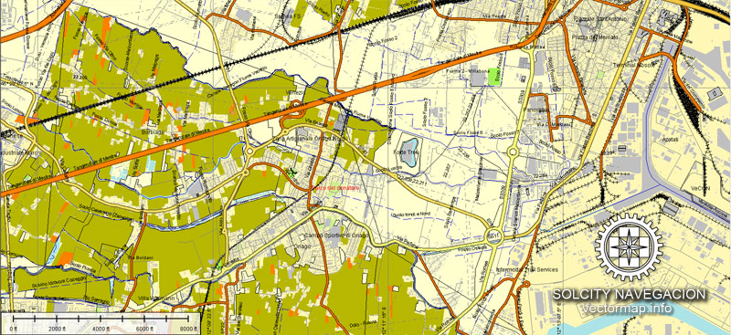
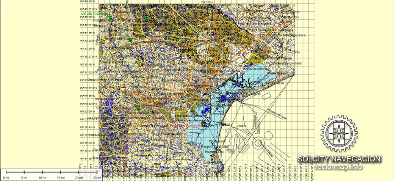
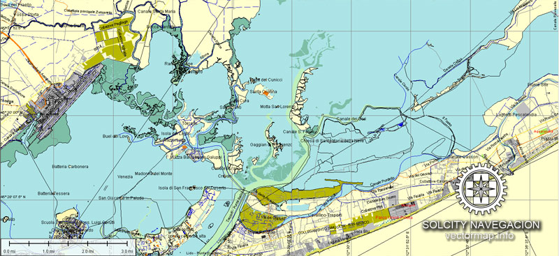
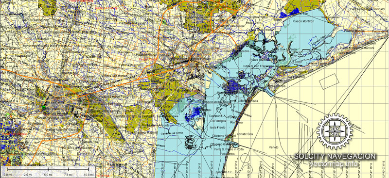
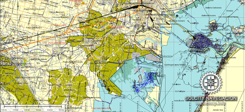
Cities and counties near Venezia city vectorial map, Italy, Europe
Our vector map of Venezia includes maps of the nearest areas (see the preview):
Santa Maria di Piave, Le Trezze, Portegrandi, Bagaggiolo, Altino, Favaro Veneto, Mestre, Favorita, Moranzani, Isola delle Tresse, Oriago, Pansac, Dogaletto, Murano, Lido, Lido di Venezia, Santa Maria del Mare, Cavallino, Marina di Cavallino, Ca`Crema, Ca`Savio, Ca`Pasquali, Lio Piccolo, Lido di Jesolo, Praello, Ghetto, Mogiliano Veneto, Olmo, Marcon, Mirano, Dolo, Cazzago, Spinea.
Purchasing and downloading of Illustrator Venezia (Italy) vectorial map
We accept PayPal and Credit Card payment. After the payment you will be redirected to the download page. We guarantee 100% satisfaction.
VectorMap. Providing detailed vector maps at the best quality of the market. Enjoy!
IT:A proposito di mappa scalabile città vettoriale di Venezia, Italia, Europa
Dimensioni dell’archivio: 194 Mb, AI zip
DPI: 300
Licenza: Royalty Free
Questa mappa dettagliata e stratificata di Venezia (Italia) è compatibile con tutti i formati vettoriali: a mano libera, Corel Draw, AutoCad e altri. Completamente modificabili, è possibile cambiare i nomi, spessore della linea, colori, riempimento, font o aggiungere oggetti necessari.
Questo Venezia mappa vettoriale caratteristiche:
Autostrade con nomi,
Le principali strade con nomi,
Strade principali,
Parco Nazionale Borders,
Aeroporti,
Le linee ferroviarie con fermate,
Latitudine e longitudine dei dati,
Minori Strade,
Strade private,
Cimiteri,
Grandi e piccoli fiumi, piccoli corsi d’acqua, anche
Lago, stagni e altri corpi idrici,
Riempimento punto di riferimento,
Zone ricreative,
Contea Bordi con riempimento,
Strade marciapiede / pedonale / pedonali,
Linee elettriche,
Parchi.
Probabilmente avete bisogno di più dati, o qualcosa di speciale? Per favore, non esitate a contattare il nostro team amichevole.
Città e contee vicino Venezia mappa della città vettoriale, Italia, Europa
La nostra mappa vettore di Venezia comprende mappe delle aree più vicine (vedere l’anteprima):
Santa Maria di Piave, Le Trezze, Portegrandi, Bagaggiolo, Altino, Favaro Veneto, Mestre, Favorita, Moranzani, Isola delle Tresse, Oriago, Pansac, Dogaletto, Murano, Lido, Lido di Venezia, Santa Maria del Mare, Cavallino, Marina di Cavallino Ca`Crema, Ca`Savio, Ca`Pasquali, Lio Piccolo, Lido di Jesolo, Praello, Ghetto, Mogiliano Veneto, Olmo, Marcon, Mirano, Dolo, Cazzago, Spinea.
Acquisto e download di Illustrator Venezia (Italia) vettoriale mappa
Accettiamo PayPal e la carta di credito il pagamento. Dopo il pagamento sarete reindirizzati alla pagina di download. Garantiamo la soddisfazione 100%.
VectorMap. Fornire vettoriali dettagliate mappe alla migliore qualità del mercato. Godere!


 Author: Kirill Shrayber, Ph.D. FRGS

