Administrative Vector Map Switzerland Adobe Illustrator Editable PDF SVG layers simplified Provinces Counties for use in the interactive media projects special edition
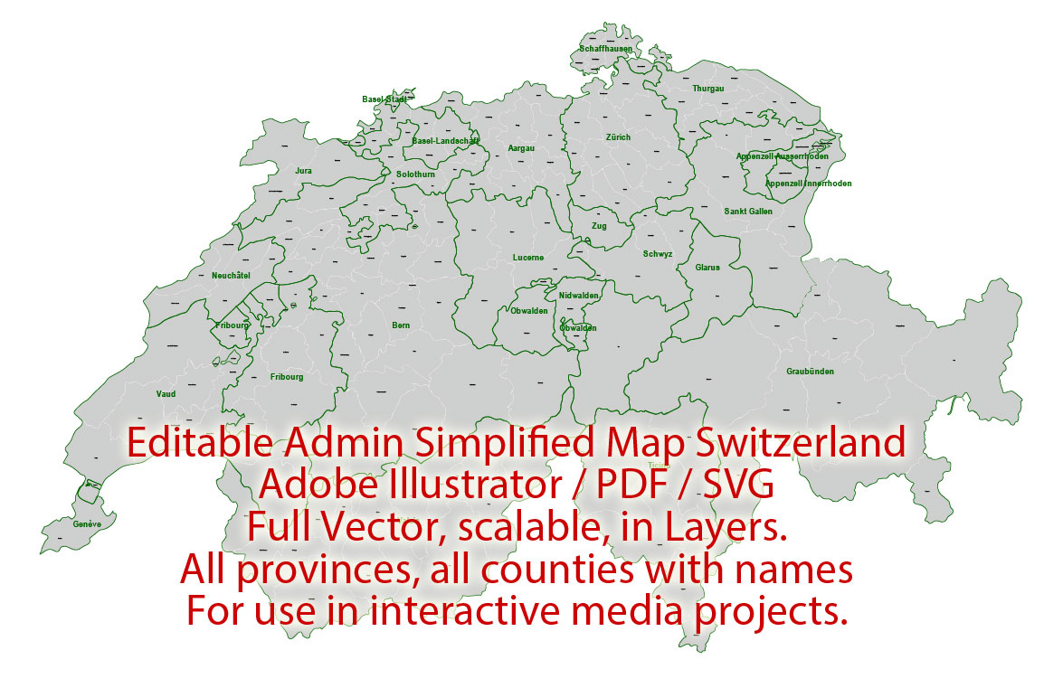
Layers: Counties_with_names, Borders_provinces, Names_provinces.
Text format all names
Ready for use in interactive media projects such as http://jvectormap.com/ or jQuery Mapael https://www.vincentbroute.fr/mapael/ https://github.com/neveldo/jQuery-Mapael
Switzerland.
This vector map of Switzerland is used as a basis for design, editing, and further printing.
This is the most detailed, exact map of Switzerland for high-quality printing and polygraphy. You can always clarify the map development date by contacting us.
For your convenience, all objects on Switzerland vector map are divided into layers. And the editing is very easy – colors, lines, etc.
You can easily add any objects needed (e.g. shops, salons, sale points, gas station or attraction) on any layer of Switzerland vector map.
Switzerland is a country in Europe. It consists of 26 cantons, and the city of Bern is the seat of the federal authorities. The sovereign state is a federal republic situated in western, central and southern Europe, and is bordered by Italy to the south, France to the west, Germany to the north, and Austria and Liechtenstein to the east.
One of the advantages of Switzerland vector maps of our production is the relevance of cartographic data, we constantly update all our products.
This vector map of Switzerland is used by:
designers, layout designers, printers, advertisers and architects. Our product – vector maps – is designed for further editing and printing in large formats – from @Wall format (a few meters) to A-0 and A-1, A-2, A-3.
The Switzerland map in vector format is used for design, urban planning, presentations and media visualizations.
The advertising and presentation map of Switzerland (usually the final designer marks the routes, and puts the client’s objects (shops, saloons, gas stations etc.)
The undoubted advantage is that people will NEVER throw out this advertising product – the map. In fact, as an advertising medium, a map is the most “long-playing” of the well-known polygraphic advertising media, with the longest lifespan, and the maximum number of interactions with the customer.
For travelers, maps are sold at the airports and gas stations around the world. Often the source is our vector maps.
Take a look, who purchases our vector maps of Switzerland in “Our Clients and Friends” page – these are large and small companies, from super-brands like Volvo and Starbucks, to small design studios and printing houses.
It’s very easy to work with vector maps of Switzerland city, even for a not very experienced designer who can turn on and off the map layers, add new objects, change the colors of fill and lines according to customer requirements.
The undoubted advantage of Switzerland vector maps in printing is an excellent and detailed visualization, when customer can expand a large paper map and instantly define his location, find a landmark, an object or address on map, unlike using the popular electronic formats of Google and Yandex maps for example.
Printable vector maps of Switzerland are much more convenient and efficient than any electronic maps on your smartphone, because ALL DETAILS are displayed in the entire space of Switzerland map.
Useful tips on working with vector maps of cities and countries in Adobe Illustrator.
«V» – launches the Selection tool (cursor, black arrow), which makes active any vector line.
«А» – launches the Direct Selection tool (white cursor), allows you to select curve elements and drag them to the desired place.
«R» – activates the Rotate tool, which helps you rotating selected objects around the center point by 360 degrees.
«E» – gives you the opportunity to use the Eraser tool and erase unnecessary parts.
«X» – switches between Fill and Stroke in the Tools section. Try to get used to this hot key and
you will quickly understand that you can’t live and work without it.
Guides are not limited to vertical and horizontal in Adobe Illustrator. You can also create a diagonal guide for example. Moreover, you can turn any contours into guides. Select the outline and go to View > Guides > Make Guides (Create Guides), or simply press Cmd/Ctrl + 5. You can also turn the guides back into an editable object. Go to menu, View > Guides > Unlock Guides (Release Guides), select the guide you want to edit and select View > Guides > Release Guides (Reset Guides), or just press Cmd/Ctrl + Option / Alt + 5).
Switzerland is a landlocked country geographically divided between the Alps, the Swiss Plateau and the Jura, spanning a total area of 41,285 km2 (15,940 sq mi) (land area 39,997 km2 (15,443 sq mi)). While the Alps occupy the greater part of the territory, the Swiss population of approximately eight-and-a-half million people is concentrated mostly on the plateau, where the largest cities are to be found: among them are the two global cities and economic centres Zürich and Geneva.
You will probably want to change the color scheme used on our Switzerland vector map.
To quickly and effectively play with colors.
Of course, you can do it manually, all objects in our Switzerland vector map are divided according to types and layers, and you can easily change the color gamma of vector objects in groups and layers.
But there is more effective way of working with the whole VECTOR MAP of Switzerland and all layers:
The overview dialog «Edit colors»/«Repaint Graphic Object» (this dialog box name can change depending on the context):
If you have selected a part or a layer of Switzerland vector map and open the dialog box by clicking the icon in the Control panel, on the Samples palette or the Color Catalog, or if you choose Edit > Edit Colors> Repaint Graphic Object, then the «Repaint Graphic Object» dialog box appears, and you get access to «Assign» and «Edit» tabs.
If a picture or a map fragment is not selected, and you open the dialog box by clicking the icon in the Control panel, on the Samples palette or in the Color Catalog, the «Edit Colors» dialog box appears and you can only access the «Edit» tab.
Regardless of the name at the top of the dialog box, the right-hand side always displays the color group of the current document, as well as two default color groups: Print Color and Grayscale. These color groups can be selected and used any time.
Create and edit color groups of Switzerland vector map, and also assign colors using the «Edit Colors»/ а «Repaint Graphic Object» dialog box.
A. Creating and editing of a color group on the «Edit» tab
B. Assigning colors on the «Assign» tab
C. Select a group of colors from the «Color groups» list
The option «Repaint a graphic object» in the lower part of the dialog box allows you to preview the colors on a selected layer of Vector map, or a group of elements, and specify whether its colors will be redefined when the dialog box is closed.
The main areas of the dialog box are:
«Edit»
The «Edit» tab is designed to create a new or edit the existing color groups.
The harmony rules Menu and the Color Wheel are used to conduct experiments with color harmonies. The color wheel shows how colors are related in color harmony, and the color bars allow you to view and manipulate an individual color values. In addition, you can adjust the brightness, add and remove colors, save color groups and view colors on the selected Vector Map of Switzerland or a separated layers.
«Assign»
The «Assign» tab is used to view and control on how the original colors are replaced with colors from the color group like your corporate colors in the Vector Map of Switzerland city.
The assign color ability is provided only if the entire map, layer or fragment is selected in the document. You can specify which of new colors replace the current colors, whether the spot colors should be preserved and how colors are replaced (for example, you can replace colors completely or changing the color tone while maintaining the brightness). The «Assign» tab allows you to redefine colors in the Vector Map of Switzerland city, or in separate layers and fragments using the current color group or reducing the number of colors in the current Vector Map.
Color groups
Is a list of all saved color groups for current document (the same groups appear in the «Samples» palette). You can edit and delete the existing color groups, as well as creating a new ones using the list of “Color Groups” in the dialog box. All changes appear in the «Samples» palette.
The highlighted color group shows, which color group is currently edited.
Any color group can be selected and edited, or used to redefine the colors in the selected vector map of Switzerland city, its fragments or elements.
Saving a color group adds this group to the specified list.
Opening the «Edit Colors»/«Repaint Graphic Object» dialog box.
Open the «Edit Colors»/«Repaint Graphic Object» dialog box using one of the following methods:
«Edit»> «Edit Colors»> «Repaint Graphic object» or «Repaint With Style».
Use these commands if you need to edit the colors in the selected vector map of Switzerland city.
«Repaint Graphic object» button on the «Control» panel.
Use this button if you need to adjust colors of Switzerland vector map using the а «Repaint graphic object» dialog box.
The establishment of the Old Swiss Confederacy dates to the late medieval period, resulting from a series of military successes against Austria and Burgundy. Swiss independence from the Holy Roman Empire was formally recognized in the Peace of Westphalia in 1648. The country has a history of armed neutrality going back to the Reformation; it has not been in a state of war internationally since 1815 and did not join the United Nations until 2002. Nevertheless, it pursues an active foreign policy and is frequently involved in peace-building processes around the world. In addition to being the birthplace of the Red Cross, Switzerland is home to numerous international organisations, including the second largest UN office. On the European level, it is a founding member of the European Free Trade Association, but notably not part of the European Union, the European Economic Area or the Eurozone. However, it participates in the Schengen Area and the European Single Market through bilateral treaties.
Spanning the intersection of Germanic and Romance Europe, Switzerland comprises four main linguistic and cultural regions: German, French, Italian and Romansh. Although the majority of the population are German speaking, Swiss national identity is rooted in a common historical background, shared values such as federalism and direct democracy, and Alpine symbolism. Due to its linguistic diversity, Switzerland is known by a variety of native names: Schweiz (German); Suisse (French); Svizzera (Italian); and Svizra or (Romansh). On coins and stamps, the Latin name – frequently shortened to “Helvetia” – is used instead of the four national languages.
The specified button is available if the selected vector map or its fragment contains two or more colors.
Note. This color editing method is convenient for global color adjustment in a vector map, if global colors were not used when creating a Map of Switzerland.
The «Edit colors» button or «Edit or apply colors» on the «Color Catalog» palette
Click this button if you need to edit colors on the «Color Catalog» palette or edit and then apply them to the selected Vector Map of Switzerland or its fragment.
The «Edit color group» button or «Edit or apply color group» on the «Samples» palette.
Click this button if you need to edit the colors in the specific color group or edit and apply them to the selected Vector Map of Switzerland or a group of its elements, for example, the whole layer “Streets and lines”. You can also double-click the color group in the Samples panel to open the dialog box.
If the map file is too large and your computer freezes or even can’t open it quickly:
1. Try to reduce the color resolution of the video card (display) to 256 colors while working with a large map.
2. Using Windows Task Manager, select all the application you don’t need, while working with map, just turn them off.
3. Launch Adobe Illustrator. (DO NOT OPEN the vector map file)
4. Start the Windows Task Manager using administrator rights > Find the “Illustrator” process > set the «real time» priority,
5. Open the file. When you see the LEGACY FONT popup window – click “OK” (do not update). You can restore the TEXT later.
6. Can also be useful: When file is opened – Edit > Settings > Basic Settings > disable smoothing. /// It looks scary, but works quickly)))
We recommend saving the file in Adobe Illustrator 10 version. It’s much more stable when working with VERY BIG size files.
Switzerland is one of the most developed countries in the world, with the highest nominal wealth per adult and the eighth-highest per capita gross domestic product according to the IMF. Switzerland ranks at or near the top globally in several metrics of national performance, including government transparency, civil liberties, quality of life, economic competitiveness, and human development. Zürich and Geneva have each been ranked among the top cities in the world in terms of quality of life, with the former ranked second globally, according to Mercer.
Geography
Extending across the north and south side of the Alps in west-central Europe, Switzerland encompasses a great diversity of landscapes and climates on a limited area of 41,285 square kilometres (15,940 sq mi). The population is about 8 million, resulting in an average population density of around 195 people per square kilometre (500/sq mi). The more mountainous southern half of the country is far more sparsely populated than the northern half. In the largest Canton of Graubünden, lying entirely in the Alps, population density falls to 27 /km² (70 /sq mi). Switzerland lies between latitudes 45° and 48° N, and longitudes 5° and 11° E. It contains three basic topographical areas: the Swiss Alps to the south, the Swiss Plateau or Central Plateau, and the Jura mountains on the west. The Alps are a high mountain range running across the central-south of the country, comprising about 60% of the country’s total area. The majority of the Swiss population live in the Swiss Plateau. Among the high valleys of the Swiss Alps many glaciers are found, totalling an area of 1,063 square kilometres (410 sq mi). From these originate the headwaters of several major rivers, such as the Rhine, Inn, Ticino and Rhône, which flow in the four cardinal directions into the whole of Europe. The hydrographic network includes several of the largest bodies of freshwater in Central and Western Europe, among which are included Lake Geneva (also called le Lac Léman in French), Lake Constance (known as Bodensee in German) and Lake Maggiore. Switzerland has more than 1500 lakes, and contains 6% of Europe’s stock of fresh water. Lakes and glaciers cover about 6% of the national territory. The largest lake is Lake Geneva, in western Switzerland shared with France. The Rhône is both the main source and outflow of Lake Geneva. Lake Constance is the second largest Swiss lake and, like the Lake Geneva, an intermediate step by the Rhine at the border to Austria and Germany. While the Rhône flows into the Mediterranean Sea at the French Camargue region and the Rhine flows into the North Sea at Rotterdam in the Netherlands, about 1,000 kilometres (620 miles) apart, both springs are only about 22 kilometres (14 miles) apart from each other in the Swiss Alps.
Cantons
The cantons are federated states, have a permanent constitutional status and, in comparison with the situation in other countries, a high degree of independence. Under the Federal Constitution, all 26 cantons are equal in status, except that 6 (referred to often as the half-cantons) are represented by only one councillor (instead of two) in the Council of States and have only half a cantonal vote with respect to the required cantonal majority in referendums on constitutional amendments. Each canton has its own constitution, and its own parliament, government, police and courts. However, there are considerable differences between the individual cantons, most particularly in terms of population and geographical area. Their populations vary between 16,003 (Appenzell Innerrhoden) and 1,487,969 (Zürich), and their area between 37 km2 (14 sq mi) (Basel-Stadt) and 7,105 km2 (2,743 sq mi) (Graubünden).
Geography of Switzerland
The geography of Switzerland encompasses the geographical features of Switzerland, a mountainous and landlocked country located in Western and Central Europe. It is surrounded by 5 countries: Austria and Liechtenstein to the east, France to the west, Italy to the south and Germany to the north. Switzerland has a maximum north–south length of 220 kilometres (140 mi) and an east–west length of about 350 kilometres (220 mi).
Switzerland is well known for the Alps in the south and south east. North of the Alps, the Swiss Plateau runs along the east–west axis of the country. Most of the population of Switzerland lives on the rolling hills and plains of the plateau. The smaller Jura Mountains are located on the north west side of the plateau. Much of the northern border with Germany follows the Rhine, though the Rhine enters Switzerland near Schaffhausen. The eastern border with Germany and a portion of Austria is drawn through Lake Constance (German: Bodensee). A portion of the southwest border with France is drawn through Lake Geneva.
Switzerland is divided into 26 sovereign cantons. The cantons along the Swiss Plateau tend to be the most populous, industrial and religiously Protestant. The cantons in the Alps tend to be less populous, Catholic, and have an agrarian or tourism-based economy.
Switzerland is also divided by language. There are four official languages: German (spoken by 63.7% of population), French (by 20.4% of population), Italian (by 6.5%) and Romansh (0.5%). From Bern east (except Ticino) the population generally speaks German. West of Bern, the population generally speaks French. In the southern Canton of Ticino, most people speak Italian. Romansh, a group of dialects descended from Vulgar Latin, is spoken in several regions in the canton of Graubünden.
Physical description
Switzerland extends between the parallels 45°49’05 and 47°48’30 lat. and the meridians 5° 57’23 and 10°29’31 long. It forms an irregular quadrilateral, of which the greatest length from east to west is 350 kilometres (220 mi), and the greatest breadth from north to south is nearly 220 kilometres (140 mi). Switzerland is a landlocked country, the closest coastline being at the Gulf of Genoa, 160 km south of Chiasso. Its political boundaries often do not coincide with those of nature. The entire canton of Ticino is south of the Alps, as are the valleys of Simplon (Valais), Mesocco, Bregaglia, Poschiavo and Müstair (all in Graubünden); the whole canton of Schaffhausen and part of that of Basel are north of the Rhine, while a large part of Graubünden lies to the east of the Rhine basin, and Porrentruy is far down on the western slope of the Jura. Putting these exceptional cases aside, the physical geography of Switzerland may thus be described: On the south runs the main chain of the Alps, which is joined (at Mont Dolent near Martigny) by the lower ranges that rise south of Lake Geneva, and which continues partly Swiss till close to Piz Lad on the east.
To the north of this main chain there is another great range of mountains (wholly Swiss) only slightly inferior in extent and height, which starts from the hills known as the Jorat range above Lausanne, reaches maximum in the great snowy summits of the Bernese Alps and the Tödi group, before trending to the north near Chur and, after rising once more in the Säntis group, dies away on the southern shore of Lake Constance.
The Swiss portion of the main chain of the Alps and the great northern outlier run parallel to each other from Martigny to near Chur, while for a short distance they actually unite near Pizzo Rotondo (west of the St Gotthard Pass), parting again near the Oberalp Pass (east of the St Gotthard). Between these two great snowclad ranges flow two of the mightiest European rivers, the Rhône towards the west and the Rhine towards the east, their headwaters being only separated by the tangled mountain mass between Pizzo Rotondo and the Oberalp Pass, which sends the Reuss towards the north and the Ticino towards the south.
To the north of the great northern outlier rises the Jura range, a huge spur of the Alps (with which it is connected by the Jorat range), while between the northern outlier and the Jura extends what may be called the plains or plateau of Switzerland, consisting almost wholly of the undulating valley of the Aare (below Thun) with its numerous affluents. To that river valley, the valley of the Thur (a direct affluent of the Rhine), that lies between the Aare basin and the Rhine basin (Lake Constance) must be added.
Putting aside the valleys of the Ticino and Inn, Switzerland may thus be described as consisting of three great river valleys (Rhône, Rhine and Aare) with the smaller one of the Thur, which all lie to the north of the main chain of the Alps and include the region between the Alps and the Jura. If matters are examined more carefully, it can be noted that the Rhône and Rhine valleys are shut off from that of the Aare (and of the Thur) by the great northern outlier of the Alps, which consists of the Bernese and Glarus Alps. Two wide and undulating valleys (Aare and Thur) and two deeply cut trenches (Rhône and Rhine) thus lie on the northern slope of the Alps, to the north and south respectively of the great northern outlier of the Alps. The main chain of the Alps rises in Swiss territory to the height of 4,634 metres (15,203 ft) in the loftiest summit or Dufourspitze (wholly Swiss) of Monte Rosa, though the Dom (4,545 metres (14,911 ft)), in the Mischabel range, is the highest mountain mass which is entirely within Switzerland. The great northern outlier attains a height of 4,274 metres (14,022 ft) in the Finsteraarhorn, while the lowest level (193 metres (633 ft)) within the Confederation, is on Lake Maggiore (on the course of the Ticino). The highest permanently inhabited village in Switzerland is Juf (2,126 metres (6,975 ft)) at the head of the Avers valley (a tributary of the Rhine), while the lowest is Ascona (196 metres (643 ft)), on Lake Maggiore.
Switzerland
Country in Europe
Switzerland is a mountainous Central European country, home to numerous lakes, villages and the high peaks of the Alps. Its cities contain medieval quarters, with landmarks like capital Bern’s Zytglogge clock tower and Lucerne’s wooden chapel bridge. The country is also known for its ski resorts and hiking trails. Banking and finance are key industries, and Swiss watches and chocolate are world renowned.
Currency: Swiss franc Trending
Dialing code: +41
Official languages: French, German, Italian, Romansh

 Author: Kirill Shrayber, Ph.D. FRGS