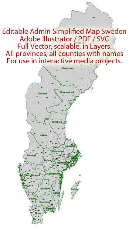
Administrative Vector Map Sweden Adobe Illustrator Editable PDF SVG layers simplified Provinces Counties for use in the interactive media projects special edition
Layers: Counties_with_names, Borders_provinces, Names_provinces.
Text format all names
Ready for use in interactive media projects such as http://jvectormap.com/ or jQuery Mapael https://www.vincentbroute.fr/mapael/ https://github.com/neveldo/jQuery-Mapael
Sweden.
This vector map of Sweden is used as a basis for design, editing, and further printing.
This is the most detailed, exact map of Sweden for high-quality printing and polygraphy. You can always clarify the map development date by contacting us.
For your convenience, all objects on Sweden vector map are divided into layers. And the editing is very easy – colors, lines, etc.
You can easily add any objects needed (e.g. shops, salons, sale points, gas station or attraction) on any layer of Sweden vector map.
Sweden is a Scandinavian Nordic country in Northern Europe. It borders Norway to the west and north and Finland to the east, and is connected to Denmark in the southwest by a bridge-tunnel across the Öresund, a strait at the Swedish-Danish border. At 450,295 square kilometres (173,860 sq mi), Sweden is the largest country in Northern Europe, the third-largest country in the European Union and the fifth largest country in Europe by area. Sweden has a total population of 10.2 million of which 2.4 million has a foreign background. It has a low population density of 22 inhabitants per square kilometre (57/sq mi). The highest concentration is in the southern half of the country.
One of the advantages of Sweden vector maps of our production is the relevance of cartographic data, we constantly update all our products.
This vector map of Sweden is used by:
designers, layout designers, printers, advertisers and architects. Our product – vector maps – is designed for further editing and printing in large formats – from @Wall format (a few meters) to A-0 and A-1, A-2, A-3.
The Sweden map in vector format is used for design, urban planning, presentations and media visualizations.
The advertising and presentation map of Sweden (usually the final designer marks the routes, and puts the client’s objects (shops, saloons, gas stations etc.)
The undoubted advantage is that people will NEVER throw out this advertising product – the map. In fact, as an advertising medium, a map is the most “long-playing” of the well-known polygraphic advertising media, with the longest lifespan, and the maximum number of interactions with the customer.
For travelers, maps are sold at the airports and gas stations around the world. Often the source is our vector maps.
Take a look, who purchases our vector maps of Sweden in “Our Clients and Friends” page – these are large and small companies, from super-brands like Volvo and Starbucks, to small design studios and printing houses.
It’s very easy to work with vector maps of Sweden city, even for a not very experienced designer who can turn on and off the map layers, add new objects, change the colors of fill and lines according to customer requirements.
The undoubted advantage of Sweden vector maps in printing is an excellent and detailed visualization, when customer can expand a large paper map and instantly define his location, find a landmark, an object or address on map, unlike using the popular electronic formats of Google and Yandex maps for example.
Printable vector maps of Sweden are much more convenient and efficient than any electronic maps on your smartphone, because ALL DETAILS are displayed in the entire space of Sweden map.
Useful tips on working with vector maps of cities and countries in Adobe Illustrator.
«V» – launches the Selection tool (cursor, black arrow), which makes active any vector line.
«А» – launches the Direct Selection tool (white cursor), allows you to select curve elements and drag them to the desired place.
«R» – activates the Rotate tool, which helps you rotating selected objects around the center point by 360 degrees.
«E» – gives you the opportunity to use the Eraser tool and erase unnecessary parts.
«X» – switches between Fill and Stroke in the Tools section. Try to get used to this hot key and
you will quickly understand that you can’t live and work without it.
Guides are not limited to vertical and horizontal in Adobe Illustrator. You can also create a diagonal guide for example. Moreover, you can turn any contours into guides. Select the outline and go to View > Guides > Make Guides (Create Guides), or simply press Cmd/Ctrl + 5. You can also turn the guides back into an editable object. Go to menu, View > Guides > Unlock Guides (Release Guides), select the guide you want to edit and select View > Guides > Release Guides (Reset Guides), or just press Cmd/Ctrl + Option / Alt + 5).
You will probably want to change the color scheme used on our Sweden vector map.
To quickly and effectively play with colors.
Of course, you can do it manually, all objects in our Sweden vector map are divided according to types and layers, and you can easily change the color gamma of vector objects in groups and layers.
But there is more effective way of working with the whole VECTOR MAP of Sweden and all layers:
The overview dialog «Edit colors»/«Repaint Graphic Object» (this dialog box name can change depending on the context):
If you have selected a part or a layer of Sweden vector map and open the dialog box by clicking the icon in the Control panel, on the Samples palette or the Color Catalog, or if you choose Edit > Edit Colors> Repaint Graphic Object, then the «Repaint Graphic Object» dialog box appears, and you get access to «Assign» and «Edit» tabs.
If a picture or a map fragment is not selected, and you open the dialog box by clicking the icon in the Control panel, on the Samples palette or in the Color Catalog, the «Edit Colors» dialog box appears and you can only access the «Edit» tab.
Regardless of the name at the top of the dialog box, the right-hand side always displays the color group of the current document, as well as two default color groups: Print Color and Grayscale. These color groups can be selected and used any time.
Create and edit color groups of Sweden vector map, and also assign colors using the «Edit Colors»/ а «Repaint Graphic Object» dialog box.
A. Creating and editing of a color group on the «Edit» tab
B. Assigning colors on the «Assign» tab
C. Select a group of colors from the «Color groups» list
The option «Repaint a graphic object» in the lower part of the dialog box allows you to preview the colors on a selected layer of Vector map, or a group of elements, and specify whether its colors will be redefined when the dialog box is closed.
The main areas of the dialog box are:
«Edit»
The «Edit» tab is designed to create a new or edit the existing color groups.
The harmony rules Menu and the Color Wheel are used to conduct experiments with color harmonies. The color wheel shows how colors are related in color harmony, and the color bars allow you to view and manipulate an individual color values. In addition, you can adjust the brightness, add and remove colors, save color groups and view colors on the selected Vector Map of Sweden or a separated layers.
«Assign»
The «Assign» tab is used to view and control on how the original colors are replaced with colors from the color group like your corporate colors in the Vector Map of Sweden city.
The assign color ability is provided only if the entire map, layer or fragment is selected in the document. You can specify which of new colors replace the current colors, whether the spot colors should be preserved and how colors are replaced (for example, you can replace colors completely or changing the color tone while maintaining the brightness). The «Assign» tab allows you to redefine colors in the Vector Map of Sweden city, or in separate layers and fragments using the current color group or reducing the number of colors in the current Vector Map.
Color groups
Is a list of all saved color groups for current document (the same groups appear in the «Samples» palette). You can edit and delete the existing color groups, as well as creating a new ones using the list of “Color Groups” in the dialog box. All changes appear in the «Samples» palette.
The highlighted color group shows, which color group is currently edited.
Any color group can be selected and edited, or used to redefine the colors in the selected vector map of Sweden city, its fragments or elements.
Saving a color group adds this group to the specified list.
Opening the «Edit Colors»/«Repaint Graphic Object» dialog box.
Open the «Edit Colors»/«Repaint Graphic Object» dialog box using one of the following methods:
«Edit»> «Edit Colors»> «Repaint Graphic object» or «Repaint With Style».
Use these commands if you need to edit the colors in the selected vector map of Sweden city.
«Repaint Graphic object» button on the «Control» panel.
Use this button if you need to adjust colors of Sweden vector map using the а «Repaint graphic object» dialog box.
The specified button is available if the selected vector map or its fragment contains two or more colors.
Note. This color editing method is convenient for global color adjustment in a vector map, if global colors were not used when creating a Map of Sweden.
The «Edit colors» button or «Edit or apply colors» on the «Color Catalog» palette
Click this button if you need to edit colors on the «Color Catalog» palette or edit and then apply them to the selected Vector Map of Sweden or its fragment.
The «Edit color group» button or «Edit or apply color group» on the «Samples» palette.
Click this button if you need to edit the colors in the specific color group or edit and apply them to the selected Vector Map of Sweden or a group of its elements, for example, the whole layer “Streets and lines”. You can also double-click the color group in the Samples panel to open the dialog box.
If the map file is too large and your computer freezes or even can’t open it quickly:
1. Try to reduce the color resolution of the video card (display) to 256 colors while working with a large map.
2. Using Windows Task Manager, select all the application you don’t need, while working with map, just turn them off.
3. Launch Adobe Illustrator. (DO NOT OPEN the vector map file)
4. Start the Windows Task Manager using administrator rights > Find the “Illustrator” process > set the «real time» priority,
5. Open the file. When you see the LEGACY FONT popup window – click “OK” (do not update). You can restore the TEXT later.
6. Can also be useful: When file is opened – Edit > Settings > Basic Settings > disable smoothing. /// It looks scary, but works quickly)))
We recommend saving the file in Adobe Illustrator 10 version. It’s much more stable when working with VERY BIG size files.
Germanic peoples have inhabited Sweden since prehistoric times, emerging into history as the Geats (Swedish Götar) and Swedes (Svear) and constituting the sea peoples known as the Norsemen. Southern Sweden is predominantly agricultural, while the north is heavily forested. Sweden is part of the geographical area of Fennoscandia. The climate is in general very mild for its northerly latitude due to significant maritime influence, that in spite of this still retains warm continental summers. Today, the sovereign state of Sweden is a constitutional monarchy and parliamentary democracy, with a monarch as head of state, like its neighbour Norway. The capital city is Stockholm, which is also the most populous city in the country. Legislative power is vested in the 349-member unicameral Riksdag. Executive power is exercised by the government chaired by the prime minister. Sweden is a unitary state, currently divided into 21 counties and 290 municipalities.
An independent Swedish state emerged during the early 12th century. After the Black Death in the middle of the 14th century killed about a third of the Scandinavian population, the Hanseatic League threatened Scandinavia’s culture, finances and languages. This led to the forming of the Scandinavian Kalmar Union in 1397, which Sweden left in 1523. When Sweden became involved in the Thirty Years War on the Reformist side, an expansion of its territories began and eventually the Swedish Empire was formed. This became one of the great powers of Europe until the early 18th century. Swedish territories outside the Scandinavian Peninsula were gradually lost during the 18th and 19th centuries, ending with the annexation of present-day Finland by Russia in 1809. The last war in which Sweden was directly involved was in 1814, when Norway was militarily forced into personal union. Since then, Sweden has been at peace, maintaining an official policy of neutrality in foreign affairs. The union with Norway was peacefully dissolved in 1905. Sweden was formally neutral through both world wars and the Cold War, albeit Sweden has since 2009 openly moved towards cooperation with NATO.
After the end of the Cold War, Sweden joined the European Union on 1 January 1995, but declined NATO membership, as well as Eurozone membership following a referendum. It is also a member of the United Nations, the Nordic Council, the Council of Europe, the World Trade Organization and the Organisation for Economic Co-operation and Development (OECD). Sweden maintains a Nordic social welfare system that provides universal health care and tertiary education for its citizens. It has the world’s eleventh-highest per capita income and ranks highly in numerous metrics of national performance, including quality of life, health, education, protection of civil liberties, economic competitiveness, equality, prosperity and human development.
Geography
Situated in Northern Europe, Sweden lies west of the Baltic Sea and Gulf of Bothnia, providing a long coastline, and forms the eastern part of the Scandinavian Peninsula. To the west is the Scandinavian mountain chain (Skanderna), a range that separates Sweden from Norway. Finland is located to its north-east. It has maritime borders with Denmark, Germany, Poland, Russia, Lithuania, Latvia and Estonia, and it is also linked to Denmark (south-west) by the Öresund Bridge. Its border with Norway (1,619 km long) is the longest uninterrupted border within Europe.
Sweden lies between latitudes 55° and 70° N, and mostly between longitudes 11° and 25° E (part of Stora Drammen island is just west of 11°).
At 449,964 km2 (173,732 sq mi), Sweden is the 55th-largest country in the world, the 4th-largest country entirely in Europe, and the largest in Northern Europe. The lowest elevation in Sweden is in the bay of Lake Hammarsjön, near Kristianstad, at −2.41 m (−7.91 ft) below sea level. The highest point is Kebnekaise at 2,111 m (6,926 ft) above sea level.
Sweden has 25 provinces or landskap, based on culture, geography and history. While these provinces serve no political or administrative purpose, they play an important role in people’s self-identity. The provinces are usually grouped together in three large lands, parts, the northern Norrland, the central Svealand and southern Götaland. The sparsely populated Norrland encompasses almost 60% of the country. Sweden also has the Vindelfjällen Nature Reserve, one of the largest protected areas in Europe, totaling 562,772 ha (approx. 5,628 km2).
About 15% of Sweden lies north of the Arctic Circle. Southern Sweden is predominantly agricultural, with increasing forest coverage northward. Around 65% of Sweden’s total land area is covered with forests. The highest population density is in the Öresund Region in southern Sweden, along the western coast up to central Bohuslän, and in the valley of lake Mälaren and Stockholm. Gotland and Öland are Sweden’s largest islands; Vänern and Vättern are its largest lakes. Vänern is the third largest in Europe, after Lake Ladoga and Lake Onega in Russia. Combined with the third and fourth largest lakes Mälaren and Hjälmaren, these lakes take up a significant part of the southern Sweden’s area. Sweden’s extensive waterway availability throughout the south was exploited with the building of the Göta Canal in the 19th century, shortening the potential distance between the Baltic Sea south of Norrköping and Gothenburg by using the lake and river network to facilitate the canal.
Sweden
Country in Europe
Sweden is a Scandinavian nation with thousands of coastal islands and inland lakes, along with vast boreal forests and glaciated mountains. Its principal cities, eastern capital Stockholm and southwestern Gothenburg and Malmö, are all coastal. Stockholm is built on 14 islands. It has more than 50 bridges, as well as the medieval old town, Gamla Stan, royal palaces and museums such as open-air Skansen.
Capital: Stockholm
Dialing code: +46
Capital and largest city: Stockholm; 59°21′N 18°4′E / 59.350°N 18.067°E
Population: 9.903 million
Currency: Swedish krona

 Author: Kirill Shrayber, Ph.D. FRGS

 + Relief + Admin Areas editable Adobe Illustrator in layers")