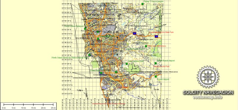
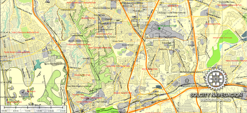
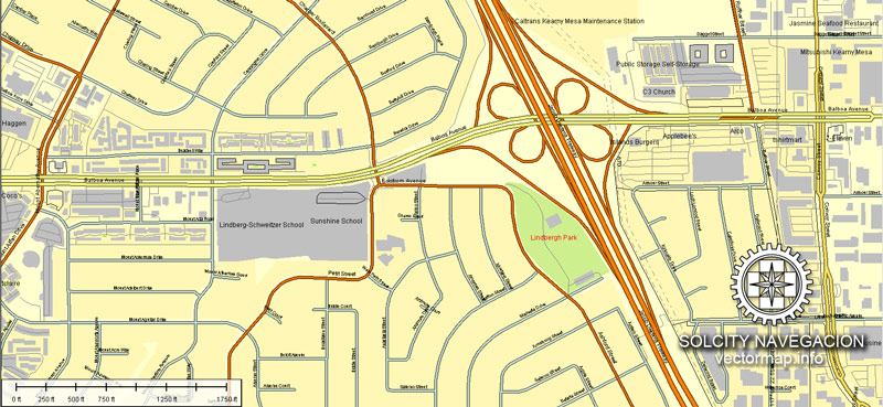
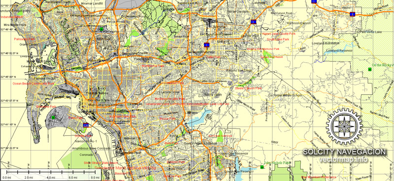
San Diego and Tijuana vector map Atlas 49 parts. California, USA
Archive size: 41 Mb, zipped .AI
DPI: 300
License: Royalty Free
[Available in PDF and other formats: .DWG; .AI; .EPS; .CDR; .PPT.]
This is a Royalty Free license. You don`t pay extra: per volume sold; for each use; for period of use.
San Diego and Tijuana (California) vector maps in Adobe Illustrator format (.AI) features (check the preview images):
Highways with names,
Major streets with names,
Major Roads,
National Park Borders,
Minor Roads,
Big and small Rivers, small streams also,
Lake, ponds and other water bodies,
Landmark fill,
Houses,
Railway lines with stops,
Recreation zones,
Parks.
We provide detailed maps of San Diego and Tijuana (California, USA) in AI. Also available in other formats (the same price): DWG, DXF AutoCAD, Corel Draw, EPS, PDF. Please also check other vector maps of USA cities.
San Diego + Tijuana, California, USA.
This vector map of San Diego city is used as a basis for design, editing, and further printing.
This is the most detailed, exact map of San Diego city for high-quality printing and polygraphy. You can always clarify the map development date by contacting us.
For your convenience, all objects on San Diego vector city map are divided into layers. And the editing is very easy – colors, lines, etc.
You can easily add any objects needed (e.g. shops, salons, sale points, gas station or attraction) on any layer of San Diego vector map.
One of the advantages of San Diego city vector maps of our production is the relevance of cartographic data, we constantly update all our products.
San Diego is a city in the U.S. state of California. It is in San Diego County, on the coast of the Pacific Ocean in Southern California, approximately 120 miles (190 km) south of Los Angeles and immediately adjacent to the border with Mexico.
With an estimated population of 1,419,516 as of July 1, 2017, San Diego is the eighth-largest city in the United States and second-largest in California. It is part of the San Diego–Tijuana conurbation, the second-largest transborder agglomeration between the U.S. and a bordering country after Detroit–Windsor, with a population of 4,922,723 people. The city is known for its mild year-round climate, natural deep-water harbor, extensive beaches, long association with the United States Navy, and recent emergence as a healthcare and biotechnology development center.
This vector map of San Diego city is used by:
designers, layout designers, printers, advertisers and architects. Our product – vector maps – is designed for further editing and printing in large formats – from @Wall format (a few meters) to A-0 and A-1, A-2, A-3.
San Diego city map in vector format is used for design, urban planning, presentations and media visualizations.
Advertising and presentation map of San Diego city (usually the final designer marks the routes, and puts the client’s objects (shops, saloons, gas stations etc.)
The undoubted advantage is that people will NEVER throw out this advertising product – the map. In fact, as an advertising medium, a city map is the most “long-playing” of the well-known polygraphic advertising media, with the longest lifespan, and the maximum number of interactions with the customer.
For travelers, maps are sold at the airports and gas stations around the world. Often the source is our vector maps.
Take a look, who purchases our vector maps of San Diego city in “Our Clients and Friends” page – these are large and small companies, from super-brands like Volvo and Starbucks, to small design studios and printing houses.
It’s very easy to work with vector maps of San Diego city, even for a not very experienced designer who can turn on and off the map layers, add new objects, change the colors of fill and lines according to customer requirements.
The undoubted advantage of San Diego city vector maps in printing is an excellent and detailed visualization, when customer can expand a large paper map and instantly define his location, find a landmark, an object or address on map, unlike using the popular electronic formats of Google and Yandex maps for example.
Printable vector maps of San Diego city are much more convenient and efficient than any electronic maps on your smartphone, because ALL DETAILS are displayed in the entire space of San Diego city map.
San Diego has been called “the birthplace of California”. Historically home to the Kumeyaay people, it was the first site visited by Europeans on what is now the West Coast of the United States. Upon landing in San Diego Bay in 1542, Juan Rodríguez Cabrillo claimed the area for Spain, forming the basis for the settlement of Alta California 200 years later. The Presidio and Mission San Diego de Alcalá, founded in 1769, formed the first European settlement in what is now California. In 1821, San Diego became part of the newly independent Mexico, which reformed as the First Mexican Republic two years later. California became part of the United States in 1848 following the Mexican–American War and was admitted to the union as a state in 1850.
The city is the seat of San Diego County and is the economic center of the region as well as the San Diego–Tijuana metropolitan area. San Diego’s main economic engines are military and defense-related activities, tourism, international trade, and manufacturing. The presence of the University of California, San Diego (UCSD), with the affiliated UCSD Medical Center, has helped make the area a center of research in biotechnology.
Useful tips on working with vector maps of cities and countries in Adobe Illustrator.
«V» – launches the Selection tool (cursor, black arrow), which makes active any vector line.
«А» – launches the Direct Selection tool (white cursor), allows you to select curve elements and drag them to the desired place.
«R» – activates the Rotate tool, which helps you rotating selected objects around the center point by 360 degrees.
«E» – gives you the opportunity to use the Eraser tool and erase unnecessary parts.
«X» – switches between Fill and Stroke in the Tools section. Try to get used to this hot key and
you will quickly understand that you can’t live and work without it.
Guides are not limited to vertical and horizontal in Adobe Illustrator. You can also create a diagonal guide for example. Moreover, you can turn any contours into guides. Select the outline and go to View > Guides > Make Guides (Create Guides), or simply press Cmd/Ctrl + 5. You can also turn the guides back into an editable object. Go to menu, View > Guides > Unlock Guides (Release Guides), select the guide you want to edit and select View > Guides > Release Guides (Reset Guides), or just press Cmd/Ctrl + Option / Alt + 5).
You will probably want to change the color scheme used on our San Diego vector city map.
To quickly and effectively play with colors.
Of course, you can do it manually, all objects in our San Diego city vector map are divided according to types and layers, and you can easily change the color gamma of vector objects in groups and layers.
But there is more effective way of working with the whole VECTOR MAP of San Diego city and all layers:
The overview dialog «Edit colors»/«Repaint Graphic Object» (this dialog box name can change depending on the context):
If you have selected a part or a layer of San Diego city vector map and open the dialog box by clicking the icon in the Control panel, on the Samples palette or the Color Catalog, or if you choose Edit > Edit Colors> Repaint Graphic Object, then the «Repaint Graphic Object» dialog box appears, and you get access to «Assign» and «Edit» tabs.
If a picture or a map fragment is not selected, and you open the dialog box by clicking the icon in the Control panel, on the Samples palette or in the Color Catalog, the «Edit Colors» dialog box appears and you can only access the «Edit» tab.
Regardless of the name at the top of the dialog box, the right-hand side always displays the color group of the current document, as well as two default color groups: Print Color and Grayscale. These color groups can be selected and used any time.
Create and edit color groups of San Diego city vector map, and also assign colors using the «Edit Colors»/ а «Repaint Graphic Object» dialog box.
A. Creating and editing of a color group on the «Edit» tab
B. Assigning colors on the «Assign» tab
C. Select a group of colors from the «Color groups» list
The option «Repaint a graphic object» in the lower part of the dialog box allows you to preview the colors on a selected layer of Vector map, or a group of elements, and specify whether its colors will be redefined when the dialog box is closed.
The main areas of the dialog box are:
«Edit»
The «Edit» tab is designed to create a new or edit the existing color groups.
The harmony rules Menu and the Color Wheel are used to conduct experiments with color harmonies. The color wheel shows how colors are related in color harmony, and the color bars allow you to view and manipulate an individual color values. In addition, you can adjust the brightness, add and remove colors, save color groups and view colors on the selected Vector Map of San Diego city or a separated layers.
«Assign»
The «Assign» tab is used to view and control on how the original colors are replaced with colors from the color group like your corporate colors in the Vector Map of San Diego city.
The assign color ability is provided only if the entire map, layer or fragment is selected in the document. You can specify which of new colors replace the current colors, whether the spot colors should be preserved and how colors are replaced (for example, you can replace colors completely or changing the color tone while maintaining the brightness). The «Assign» tab allows you to redefine colors in the Vector Map of San Diego city, or in separate layers and fragments using the current color group or reducing the number of colors in the current Vector Map.
Color groups
Is a list of all saved color groups for current document (the same groups appear in the «Samples» palette). You can edit and delete the existing color groups, as well as creating a new ones using the list of “Color Groups” in the dialog box. All changes appear in the «Samples» palette.
The highlighted color group shows, which color group is currently edited.
Any color group can be selected and edited, or used to redefine the colors in the selected vector map of San Diego city, its fragments or elements.
Saving a color group adds this group to the specified list.
Opening the «Edit Colors»/«Repaint Graphic Object» dialog box.
Open the «Edit Colors»/«Repaint Graphic Object» dialog box using one of the following methods:
«Edit»> «Edit Colors»> «Repaint Graphic object» or «Repaint With Style».
Use these commands if you need to edit the colors in the selected vector map of San Diego city.
«Repaint Graphic object» button on the «Control» panel.
Use this button if you need to adjust colors of San Diego city vector map using the а «Repaint graphic object» dialog box.
The specified button is available if the selected vector map or its fragment contains two or more colors.
Note. This color editing method is convenient for global color adjustment in a vector map, if global colors were not used when creating a City Map of San Diego.
The «Edit colors» button or «Edit or apply colors» on the «Color Catalog» palette
Click this button if you need to edit colors on the «Color Catalog» palette or edit and then apply them to the selected Vector Map of San Diego city or its fragment.
The «Edit color group» button or «Edit or apply color group» on the «Samples» palette.
Click this button if you need to edit the colors in the specific color group or edit and apply them to the selected Vector Map of San Diego city or a group of its elements, for example, the whole layer “Streets and lines”. You can also double-click the color group in the Samples panel to open the dialog box.
If the map file is too large and your computer freezes or even can’t open it quickly:
1. Try to reduce the color resolution of the video card (display) to 256 colors while working with a large map.
2. Using Windows Task Manager, select all the application you don’t need, while working with map, just turn them off.
3. Launch Adobe Illustrator. (DO NOT OPEN the vector map file)
4. Start the Windows Task Manager using administrator rights > Find the “Illustrator” process > set the «real time» priority,
5. Open the file. When you see the LEGACY FONT popup window – click “OK” (do not update). You can restore the TEXT later.
6. Can also be useful: When file is opened – Edit > Settings > Basic Settings > disable smoothing. /// It looks scary, but works quickly)))
We recommend saving the file in Adobe Illustrator 10 version. It’s much more stable when working with VERY BIG size files.
According to SDSU professor emeritus Monte Marshall, San Diego Bay is “the surface expression of a north-south-trending, nested graben”. The Rose Canyon and Point Loma fault zones are part of the San Andreas Fault system. About 40 miles (64 km) east of the bay are the Laguna Mountains in the Peninsular Ranges, which are part of the backbone of the American continents.
The city lies on approximately 200 deep canyons and hills separating its mesas, creating small pockets of natural open space scattered throughout the city and giving it a hilly geography. Traditionally, San Diegans have built their homes and businesses on the mesas, while leaving the urban canyons relatively wild. Thus, the canyons give parts of the city a segmented feel, creating gaps between otherwise proximate neighborhoods and contributing to a low-density, car-centered environment. The San Diego River runs through the middle of San Diego from east to west, creating a river valley which serves to divide the city into northern and southern segments. During the historic period and presumably earlier as well, the river has shifted its flow back and forth between San Diego Bay and Mission Bay, and its fresh water was the focus of the earliest Spanish explorers. Miguel Costansó, a cartographer, wrote in 1769, “When asked by signs where the watering-place was, the Indians pointed to a grove which could be seen at a considerable distance to the northeast, giving to understand that a river or creek flowed through it, and that they would lead our men to it if they would follow.” That river was the San Diego River. Several reservoirs and Mission Trails Regional Park also lie between and separate developed areas of the city.
Mission Valley facing Northwest, taken from Arista Street. Mission Bay can be seen in the distance.
Notable peaks within the city limits include Cowles Mountain, the highest point in the city at 1,591 feet (485 m); Black Mountain at 1,558 feet (475 m); and Mount Soledad at 824 feet (251 m). The Cuyamaca Mountains and Laguna Mountains rise to the east of the city, and beyond the mountains are desert areas. The Cleveland National Forest is a half-hour drive from downtown San Diego. Numerous farms are found in the valleys northeast and southeast of the city.
In its 2013 ParkScore ranking, The Trust for Public Land reported that San Diego had the 9th-best park system among the 50 most populous U.S. cities. ParkScore ranks city park systems by a formula that analyzes acreage, access, and service and investment.
San Diego was originally centered on the Old Town district, but by the late 1860s the focus had shifted to the bayfront, in the belief that this new location would increase trade. As the “New Town” – present-day Downtown – waterfront location quickly developed, it eclipsed Old Town as the center of San Diego.
The development of skyscrapers over 300 feet (91 m) in San Diego is attributed to the construction of the El Cortez Hotel in 1927, the tallest building in the city from 1927 to 1963. As time went on, multiple buildings claimed the title of San Diego’s tallest skyscraper, including the Union Bank of California Building and Symphony Towers. Currently the tallest building in San Diego is One America Plaza, standing 500 feet (150 m) tall, which was completed in 1991. The downtown skyline contains no super-talls, as a regulation put in place by the Federal Aviation Administration in the 1970s set a 500 feet (152 m) limit on the height of buildings within a one-mile (1.6 km) radius of the San Diego International Airport. An iconic description of the skyline includes its skyscrapers being compared to the tools of a toolbox.
Tijuana, Mexico.
Tijuana is the largest city in the Mexican state of Baja California and on the Baja California Peninsula. It is part of the San Diego–Tijuana international transborder agglomeration. As one of the largest and fastest growing cities of Mexico, Tijuana exerts a strong influence on local economics, education, culture, art, and politics. As the city has become a leading center in the country, so has the surrounding metropolitan area, a major industrial and paramount metropolis in northwestern Mexico. Currently one of the fastest growing metropolitan areas in Mexico, Tijuana maintains global city status. As of 2015, the city of Tijuana had a population of 1,641,570.
Tijuana is located on the Gold Coast of Baja California, and is the municipal seat and the cultural and commercial center of Tijuana Municipality. Tijuana covers 70% of the municipality but contains over 80% of its population. A dominant manufacturing center of the North American continent, the city maintains facilities of many multinational conglomerate companies. In the early 21st century, Tijuana became the medical-device manufacturing capital of North America. Tijuana is also a growing cultural center and has been recognized as an important new cultural mecca. The city is the most visited border city in the globe; sharing a border of about 24 km (15 mi) with its sister city San Diego. More than fifty million people cross the border between these two cities every year. This metropolitan crossing makes the San Ysidro Port of Entry the busiest land-border crossing in the world. It is estimated that the two border crossing stations between the cities proper of San Diego and Tijuana account for 300,000 daily border crossings alone.
Tijuana is the 45th largest city in the Americas and is the westernmost city in Mexico. According to the 2015 census, the Tijuana metropolitan area was the fifth-largest in Mexico, with a population of 1,840,710, but rankings vary, the city (locality) itself was 6th largest and the municipality (administrative) 3rd largest nationally. The international metropolitan region was estimated at about 5,158,459 in 2016, making it the third largest metropolitan area in the former Californias region, 19th largest metropolitan area in the Americas, and the largest bi-national conurbation that is shared between US and Mexico. Tijuana is becoming more suburbanized like San Diego.
Tijuana traces its modern history to the arrival of Spanish explorers in the 16th century who were mapping the coast of the Californias. As the American conquest of northern Mexico ended with the Treaty of Guadalupe Hidalgo, Tijuana’s new international position on the border gave rise to a new economic and political structure. The city was founded on July 11, 1889 as urban development began. Often known by its supposed initials, T.J., and nicknamed Gateway to Mexico, the city has historically served as a tourist center dating back to the 1880s.
Geography
Tijuana is the western-most city in Mexico, and consequently in Latin America, and the 2nd largest city of northern Mexico. Located about 210 kilometers (130 mi) west of the state-capital, Mexicali, the city is bordered to the north by the cities of Imperial Beach, and the San Diego neighborhoods of San Ysidro and Otay Mesa, California. To the southwest of the city is Rosarito Beach, while to the south is unincorporated territory of Tijuana Municipality. The city is nestled among hills, canyons, and gullies. The central part of the city lies in a valley through which flows the channeled Tijuana River.
Housing development in the Tijuana Hills has led to eradication of many seasonal mountain streams. This lack of natural drainage makes places within the city vulnerable to landslides during the rainy season. The varied terrain of Tijuana gives the city elevation extremes that range from sea level to 790 metres (2,590 ft).
Tijuana is noted for its rough terrain, which includes many canyons, steep hills, and mesas. Among noted canyons in Tijuana are Canyon K and Canyon Johnson. Large Tijuana hills include Red Hill (Cerro Colorado) and Hill of the Bees (Cerro de las Abejas) in the eastern part of the city.
The city is located near the terminus of the Tijuana River and within the Tijuana River Basin. The Tijuana River is an intermittent river, 195 km (121 mi) long, on the Pacific coast of northern Baja California in Mexico and Southern California in the United States. It drains an arid area along the California–Baja California border, flowing through Mexico for most of its course and then crossing the border for the last 8 km (5 mi) of its course where it forms an estuary that empties into the ocean. The river’s lower reaches harbor the last undeveloped coastal wetlands in San Diego County, and some of the last in Southern California, amidst a highly urbanized environment at the southern city limits of Imperial Beach.
As Downtown Tijuana was built at the bottom of the river valley, the district is subject to seasonal flooding created by drain-off from the Tijuana Hills. During this time, east-bound portions of the Via Rapida (east-west highway) may be blocked off by the Tijuana Police due to hazardous conditions.
Please see preview image of this vectorial city maps of San Diego and Tijuana. It has major and minor streets, and the most significant features like airports, parks and recreational zones.
This vector maps of San Diego and Tijuana can be used for large size printing (wall or bigboard) or presentation projects. Zoom without quality loss, cause it`s vector map.
The same price for every format you choose.
Fully editable vector map of San Diego and Tijuana, California. You can change fonts, colors of all objects mentioned above. This layered vector map is scalable and can be adjusted to any size you need, no matter what big it is. Zoom without quality loss.
You can edit all map data using different vector graphics editors like Adobe Illustrator, Freehand or CorelDraw, cropping, changing colors, fonts or borders, also adding your company logo or necessary objects. And also is a fully scalable map, no matter what size you need.
Probably you need more data on map? Please feel free to contact us, and we add it with no problem.
San Diego and Tijuana maps (USA) in vector. Cities and counties near
Our vector maps of San Diego and Tijuana includes maps of the nearest areas (see the preview):
Miramar, Scripps Ranch, Mira Mesa, Penasquitos, Carmel Valley, Torrey Pines, La Jolla, Pacific Beach, Old Town, Point Loma, Del Cerro, Otay Ranch, San Ysidro, Zona Norte, Garita de Otay, Spring Valley, El Cajon, Poway, Rancho Santa Fe, Cardiff, Solana Beach, Del Mar, Del Dios, Imperial Beach, Kino, La Joya, Agua Caliente, Rosarito, Cerro Colorado.
San Diego and Tijuana maps for Adobe Illustrator. Purchasing and downloading.
We accept PayPal and Credit Card payment. After the payment you will be redirected to the download page.
We have the biggest base of USA Vector Maps and other countries. Maps containing streets with names, buildings, railways and airports (see the list of POI above).
Small guide: How to work with the vector map?
You can: Mass select objects by type and color – for example, the objects type “building” (they are usually dark gray) – and remove them from the map, if you do not need them in your print or design project. You can also easily change the thickness of lines (streets), just bulk selection the road by the line color.
The streets are separated by type, for example, type “residential road” are usually white with a gray stroke. Highway usually orange with a brown or dark gray stroke.
All objects are divided by types: different types of roads and streets, polygons of buildings, landfills, urban areas, parks and more other.
It is easy to change the font of inscriptions, all or each individually. Also, just can be make and any other manipulation of objects on the vector map in Adobe illustrator format.
Important: All the proportions on the map are true, that is, the relative sizes of the objects are true, because Map is based on an accurate GPS projection, and It transated into the (usual for all) the Mercator projection.
You can easily change the color, stroke and fill of any object on the map, zoom without loss of quality Image Verification.


 Author: Kirill Shrayber, Ph.D. FRGS

