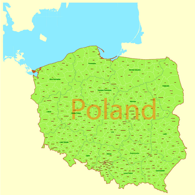
Printable PDF Vector Map Poland Admin, exact Mercator Projection, editable Layered Adobe PDF, 5 Mb ZIP.
Exact boundaries Country, Provinces and Counties with names. Map for publishing, design, printing, publications, arts, projects, presentations, for architects, designers, and builders, business, logistics. The most accurate map of this level.
Layers: Ground_sea, Provinces, Names_provinces, Counties, Names_counties, Names_country, State_boundaries
Text format all names, for High-Quality Printing
DWG, DXF, CDR, ESRI Shapes, and other formats – by request, the same price, please contact.
Poland.
This vector map of Poland is used as a basis for design, editing, and further printing.
This is the most detailed, exact map of Poland for high-quality printing and polygraphy. You can always clarify the map development date by contacting us.
For your convenience, all objects on Poland vector map are divided into layers. And the editing is very easy – colors, lines, etc.
You can easily add any objects needed (e.g. shops, salons, sale points, gas station or attraction) on any layer of Poland vector map.
One of the advantages of Poland vector maps of our production is the relevance of cartographic data, we constantly update all our products.
Poland is a country located in Central Europe. It is divided into 16 administrative subdivisions, covering an area of 312,696 square kilometres (120,733 sq mi), and has a largely temperate seasonal climate. With a population of approximately 38.5 million people, Poland is the sixth most populous member state of the European Union. Poland’s capital and largest metropolis is Warsaw. Other major cities include Kraków, Łódź, Wrocław, Poznań, Gdańsk and Szczecin.
This vector map of Poland is used by:
designers, layout designers, printers, advertisers and architects. Our product – vector maps – is designed for further editing and printing in large formats – from @Wall format (a few meters) to A-0 and A-1, A-2, A-3.
The Poland map in vector format is used for design, urban planning, presentations and media visualizations.
The advertising and presentation map of Poland (usually the final designer marks the routes, and puts the client’s objects (shops, saloons, gas stations etc.)
The undoubted advantage is that people will NEVER throw out this advertising product – the map. In fact, as an advertising medium, a map is the most “long-playing” of the well-known polygraphic advertising media, with the longest lifespan, and the maximum number of interactions with the customer.
For travelers, maps are sold at the airports and gas stations around the world. Often the source is our vector maps.
Take a look, who purchases our vector maps of Poland in “Our Clients and Friends” page – these are large and small companies, from super-brands like Volvo and Starbucks, to small design studios and printing houses.
The establishment of the Polish state can be traced back to A.D. 966, when Mieszko I, ruler of the realm coextensive with the territory of present-day Poland, converted to Christianity. The Kingdom of Poland was founded in 1025, and in 1569 it cemented its longstanding political association with the Grand Duchy of Lithuania by signing the Union of Lublin. This union formed the Polish–Lithuanian Commonwealth, one of the largest (about 1 million km2) and most populous countries of 16th- and 17th-century Europe, with a uniquely liberal political system which adopted Europe’s first written national constitution, the Constitution of 3 May 1791.
It’s very easy to work with vector maps of Poland city, even for a not very experienced designer who can turn on and off the map layers, add new objects, change the colors of fill and lines according to customer requirements.
The undoubted advantage of Poland vector maps in printing is an excellent and detailed visualization, when customer can expand a large paper map and instantly define his location, find a landmark, an object or address on map, unlike using the popular electronic formats of Google and Yandex maps for example.
Printable vector maps of Poland are much more convenient and efficient than any electronic maps on your smartphone, because ALL DETAILS are displayed in the entire space of Poland map.
More than a century after the Partitions of Poland at the end of the 18th century, Poland regained its independence in 1918 with the Treaty of Versailles. In September 1939, World War II started with the invasion of Poland by Germany, followed by the Soviet Union invading Poland in accordance with the Molotov–Ribbentrop Pact. More than six million Polish citizens perished in the war. In 1947, the Polish People’s Republic was established as a satellite state under Soviet influence. In the aftermath of the Revolutions of 1989, most notably through the emergence of the Solidarity movement, the sovereign state of Poland reestablished itself as a presidential democratic republic.
Useful tips on working with vector maps of cities and countries in Adobe Illustrator.
«V» – launches the Selection tool (cursor, black arrow), which makes active any vector line.
«А» – launches the Direct Selection tool (white cursor), allows you to select curve elements and drag them to the desired place.
«R» – activates the Rotate tool, which helps you rotating selected objects around the center point by 360 degrees.
«E» – gives you the opportunity to use the Eraser tool and erase unnecessary parts.
«X» – switches between Fill and Stroke in the Tools section. Try to get used to this hot key and
you will quickly understand that you can’t live and work without it.
Guides are not limited to vertical and horizontal in Adobe Illustrator. You can also create a diagonal guide for example. Moreover, you can turn any contours into guides. Select the outline and go to View > Guides > Make Guides (Create Guides), or simply press Cmd/Ctrl + 5. You can also turn the guides back into an editable object. Go to menu, View > Guides > Unlock Guides (Release Guides), select the guide you want to edit and select View > Guides > Release Guides (Reset Guides), or just press Cmd/Ctrl + Option / Alt + 5).
Poland is a developed market and regional power. It has the eighth largest and one of the most dynamic economies in the European Union, simultaneously achieving a very high rank on the Human Development Index. Additionally, the Polish Stock Exchange in Warsaw is the largest and most important in Central Europe. Poland is a developed country, which maintains a high-income economy along with very high standards of living, life quality, safety, education and economic freedom. Poland has a developed school educational system.
You will probably want to change the color scheme used on our Poland vector map.
To quickly and effectively play with colors.
Of course, you can do it manually, all objects in our Poland vector map are divided according to types and layers, and you can easily change the color gamma of vector objects in groups and layers.
But there is more effective way of working with the whole VECTOR MAP of Poland and all layers:
The overview dialog «Edit colors»/«Repaint Graphic Object» (this dialog box name can change depending on the context):
If you have selected a part or a layer of Poland vector map and open the dialog box by clicking the icon in the Control panel, on the Samples palette or the Color Catalog, or if you choose Edit > Edit Colors> Repaint Graphic Object, then the «Repaint Graphic Object» dialog box appears, and you get access to «Assign» and «Edit» tabs.
The country provides free university education, state-funded social security and a universal health care system for all citizens. Poland has 15 UNESCO World Heritage Sites, 14 of which are cultural. Poland is a member state of the European Union, the Schengen Area, the United Nations, NATO, the OECD, the Three Seas Initiative, and the Visegrád Group.
If a picture or a map fragment is not selected, and you open the dialog box by clicking the icon in the Control panel, on the Samples palette or in the Color Catalog, the «Edit Colors» dialog box appears and you can only access the «Edit» tab.
Regardless of the name at the top of the dialog box, the right-hand side always displays the color group of the current document, as well as two default color groups: Print Color and Grayscale. These color groups can be selected and used any time.
Create and edit color groups of Poland vector map, and also assign colors using the «Edit Colors»/ а «Repaint Graphic Object» dialog box.
A. Creating and editing of a color group on the «Edit» tab
B. Assigning colors on the «Assign» tab
C. Select a group of colors from the «Color groups» list
The option «Repaint a graphic object» in the lower part of the dialog box allows you to preview the colors on a selected layer of Vector map, or a group of elements, and specify whether its colors will be redefined when the dialog box is closed.
Geography
Poland’s territory extends across several geographical regions, between latitudes 49° and 55° N, and longitudes 14° and 25° E. In the north-west is the Baltic seacoast, which extends from the Bay of Pomerania to the Gulf of Gdańsk. This coast is marked by several spits, coastal lakes (former bays that have been cut off from the sea), and dunes. The largely straight coastline is indented by the Szczecin Lagoon, the Bay of Puck, and the Vistula Lagoon.
The main areas of the dialog box are:
«Edit»
The «Edit» tab is designed to create a new or edit the existing color groups.
The harmony rules Menu and the Color Wheel are used to conduct experiments with color harmonies. The color wheel shows how colors are related in color harmony, and the color bars allow you to view and manipulate an individual color values. In addition, you can adjust the brightness, add and remove colors, save color groups and view colors on the selected Vector Map of Poland or a separated layers.
«Assign»
The «Assign» tab is used to view and control on how the original colors are replaced with colors from the color group like your corporate colors in the Vector Map of Poland city.
The assign color ability is provided only if the entire map, layer or fragment is selected in the document. You can specify which of new colors replace the current colors, whether the spot colors should be preserved and how colors are replaced (for example, you can replace colors completely or changing the color tone while maintaining the brightness). The «Assign» tab allows you to redefine colors in the Vector Map of Poland city, or in separate layers and fragments using the current color group or reducing the number of colors in the current Vector Map.
The centre and parts of the north of the country lie within the North European Plain. Rising above these lowlands is a geographical region comprising four hilly districts of moraines and moraine-dammed lakes formed during and after the Pleistocene ice age. These lake districts are the Pomeranian Lake District, the Greater Polish Lake District, the Kashubian Lake District, and the Masurian Lake District. The Masurian Lake District is the largest of the four and covers much of north-eastern Poland. The lake districts form part of the Baltic Ridge, a series of moraine belts along the southern shore of the Baltic Sea.
Color groups
Is a list of all saved color groups for current document (the same groups appear in the «Samples» palette). You can edit and delete the existing color groups, as well as creating a new ones using the list of “Color Groups” in the dialog box. All changes appear in the «Samples» palette.
The highlighted color group shows, which color group is currently edited.
Any color group can be selected and edited, or used to redefine the colors in the selected vector map of Poland city, its fragments or elements.
Saving a color group adds this group to the specified list.
Opening the «Edit Colors»/«Repaint Graphic Object» dialog box.
Open the «Edit Colors»/«Repaint Graphic Object» dialog box using one of the following methods:
«Edit»> «Edit Colors»> «Repaint Graphic object» or «Repaint With Style».
South of the Northern European Plain are the regions of Lusatia, Silesia and Masovia, which are marked by broad ice-age river valleys. Farther south is a mountainous region, including the Sudetes, the Kraków-Częstochowa Uplands, the Świętokrzyskie Mountains, and the Carpathian Mountains, including the Beskids. The highest part of the Carpathians is the Tatra Mountains, along Poland’s southern border.
Use these commands if you need to edit the colors in the selected vector map of Poland city.
«Repaint Graphic object» button on the «Control» panel.
Use this button if you need to adjust colors of Poland vector map using the а «Repaint graphic object» dialog box.
The specified button is available if the selected vector map or its fragment contains two or more colors.
Note. This color editing method is convenient for global color adjustment in a vector map, if global colors were not used when creating a Map of Poland.
The «Edit colors» button or «Edit or apply colors» on the «Color Catalog» palette
Click this button if you need to edit colors on the «Color Catalog» palette or edit and then apply them to the selected Vector Map of Poland or its fragment.
Topography
The country extends 876 kilometers from north to south and 689 kilometers from east to west, at an area of 312,679 square kilometers including inland waters. The average elevation is 173 meters, and only 3% of Polish territory, along the southern border, is higher than 500 meters. The highest elevation is Mount Rysy, which rises 2,499 meters in the Tatra Range of the Carpathian Mountains, 95 kilometers south of Kraków. About 63 square kilometers along the Gulf of Gdańsk are below sea level.
The «Edit color group» button or «Edit or apply color group» on the «Samples» palette.
Click this button if you need to edit the colors in the specific color group or edit and apply them to the selected Vector Map of Poland or a group of its elements, for example, the whole layer “Streets and lines”. You can also double-click the color group in the Samples panel to open the dialog box.
If the map file is too large and your computer freezes or even can’t open it quickly:
1. Try to reduce the color resolution of the video card (display) to 256 colors while working with a large map.
2. Using Windows Task Manager, select all the application you don’t need, while working with map, just turn them off.
3. Launch Adobe Illustrator. (DO NOT OPEN the vector map file)
4. Start the Windows Task Manager using administrator rights > Find the “Illustrator” process > set the «real time» priority,
5. Open the file. When you see the LEGACY FONT popup window – click “OK” (do not update). You can restore the TEXT later.
6. Can also be useful: When file is opened – Edit > Settings > Basic Settings > disable smoothing. /// It looks scary, but works quickly)))
We recommend saving the file in Adobe Illustrator 10 version. It’s much more stable when working with VERY BIG size files.
Topographic regions
Poland is traditionally divided into five topographic zones from north to south.
The largest, the central lowlands or “Polish Plain” (Polish: Niż Polski or Nizina Polska), is narrow in the west, then expands to the north and south as it extends eastward. Along the eastern border, this zone reaches from the far northeast to within 200 kilometers of the southern border. The terrain in the central lowlands is quite flat, and earlier glacial lakes have been filled by sediment. The region is cut by several major rivers, including the Oder (Odra), which defines the Silesian Lowlands in the southwest, and the Vistula (Wisla), which defines the lowland areas of east-central Poland.
To the south of the lowlands are the lesser Poland uplands, a belt varying in width from 90 to 200 kilometers, formed by the gently sloping foothills of the Sudeten and Carpathian mountain ranges and the uplands that connect the ranges in southcentral Poland. The topography of this region is divided transversely into higher and lower elevations, reflecting its underlying geological structure. In the western section, the Silesia-Kraków Upthrust contains rich coal deposits.
Further information: List of mountains in Poland
The third topographic area is located on either side of Poland’s southern border and is formed by the Sudeten and Carpathian ranges. Within Poland, neither of these ranges is forbidding enough to prevent substantial habitation; the Carpathians are especially densely populated. The rugged form of the Sudeten range derives from the geological shifts that formed the later Carpathian uplift. The highest elevation in the Sudeten is Śnieżka (1,602 meters) in the Karkonosze Mountains. The Carpathians in Poland, formed as a discrete topographical unit in the relatively recent Tertiary Era, are the highest mountains in the country. They are the northernmost edge of a much larger range that extends into the Czech Republic, Slovakia, Ukraine, Hungary, and Romania. Within Poland the range includes two major basins, the Oświęcim and Sandomierz, which are rich in several minerals and natural gas.
To the north of the central lowlands, the lake region includes primeval forests – one of the last remaining in Europe and much of Poland’s shrinking unspoiled natural habitat. Glacial action in this region formed lakes and low hills in the otherwise flat terrain adjacent to Lithuania and the Baltic Sea. Small lakes dot the entire northern half of Poland, and the glacial formations that characterize the lake region extend as much as 200 kilometers inland in western Poland. Wide river valleys divide the lake region into three parts. In the northwest, Pomerania is located south of the Baltic coastal region and north of the Warta and Noteć rivers. Masuria occupies the remainder of northern Poland and features a string of larger lakes. Most of Poland’s 9,300 lakes that are more than 10,000 square metres in area are located in the northern part of the lake region, where they occupy about 10% of the surface area.
The Baltic coastal plains are a low-lying region formed of sediments deposited by the sea. The coastline was shaped by the action of the rising sea after the Scandinavian ice sheet retreated. The two major inlets in the smooth coast are the Pomeranian Bay on the German border in the far northwest and the Gulf of Gdańsk in the east. The Oder River empties into the former, and the Vistula forms a large delta at the head of the latter. Sandbars with large dunes form lagoons and coastal lakes along much of the coast.
Political geography
Poland’s current voivodeships (provinces) are largely based on the country’s historic regions, whereas those of the past two decades (to 1998) had been centred on and named for individual cities. The new units range in area from less than 10,000 square kilometres (3,900 sq mi) for Opole Voivodeship to more than 35,000 square kilometres (14,000 sq mi) for Masovian Voivodeship. Administrative authority at voivodeship level is shared between a government-appointed voivode (governor), an elected regional assembly (sejmik) and an executive elected by that assembly.
The voivodeships are subdivided into powiats (often referred to in English as counties), and these are further divided into gminas (also known as communes or municipalities). Major cities normally have the status of both gmina and powiat. Poland has 16 voivodeships, 379 powiats (including 65 cities with powiat status), and 2,478 gminas.
Poland
Country in Europe
Poland is an eastern European country on the Baltic Sea known for its medieval architecture and Jewish heritage. Warsaw, the capital, has shopping and nightlife, plus the Warsaw Uprising Museum, honoring the city’s WWII-era resistance to German occupation. In the city of Kraków, 14th-century Wawel Castle rises above the medieval old town, home to Cloth Hall, a Renaissance trading post in Rynek Glówny (market square).
Capital: Warsaw
Dialing code: +48
Currency: Polish złoty
Religion: 87.6% Roman Catholicism; 7.1% No Answer; 3.1% Other Faith; 2.2% Atheism
Minority languages: Kashubian, German, Ukrainian, Belarusian, Rusyn, Romani, Yiddish
Population: 37.95 million

 Author: Kirill Shrayber, Ph.D. FRGS


