Extended Description of the Vector Map
Printable PDF Vector Map China, exact high detailed editable layered Adobe PDF scalable, editable, text format all names, 101 MB ZIP
Names all provinces, cities and principal water objects, main airports
Map for design, printing, arts, projects, presentations, for architects, designers, and builders, business, logistics.
The most exact and detailed map of China
Map for editing and High-Quality Printing

Layers list:
- Legend
- Names Countries
- Names Provinces
- Names Places
- Names Airports
- Points Places and Capitals
- Points Airports
- Names Water Areas
- Main Roads
- Railroads
- Waterways
- Country Boundaries
- Provinces Areas (colored poygons)
- Islands
- Water objects (areas)
China has an extensive network of roads and rivers that play a critical role in its transportation, economy, and cultural development. Below is an overview of the principal roads and major rivers in China:
Principal Roads in China
- National Highways (G-Numbered Routes) :
- China’s national highway system connects all provinces, major cities, and border regions. Some of the most important highways include:
- G1 Jingha Expressway : Connects Beijing to Harbin, running through northeastern China.
- G2 Jinghu Expressway : Links Beijing to Shanghai, one of the busiest routes in the country.
- G30 Lianyungang–Khorgas Expressway : A key east-west route connecting coastal Jiangsu Province to Xinjiang near the Kazakhstan border.
- G4 Jinggangao Expressway : Runs from Beijing to Hong Kong and Macau, passing through major cities like Zhengzhou and Changsha.
- Expressways :
- China has the world’s largest expressway network, with over 160,000 kilometers as of recent estimates. Key expressways include:
- Beijing–Shanghai Expressway : A vital north-south corridor for commerce and travel.
- Shanghai–Chengdu Expressway : An east-west route linking the Yangtze River Delta to central and western China.
- Guangzhou–Kunming Expressway : Connects southern Guangdong Province to southwestern Yunnan Province.
- Belt and Road Initiative (BRI) Corridors :
- The BRI includes several domestic and international road networks aimed at enhancing connectivity within China and beyond. For example:
- The China-Pakistan Economic Corridor (CPEC) extends road links into Pakistan.
- The China-Myanmar Economic Corridor enhances trade routes between southwestern China and Southeast Asia.
- Tibetan Plateau Roads :
- These roads traverse challenging terrain and are essential for connecting remote areas:
- Qinghai-Tibet Highway : Links Xining in Qinghai Province to Lhasa in Tibet, crossing high-altitude regions.
- Sichuan-Tibet Highway : Connects Chengdu in Sichuan Province to Lhasa, offering stunning but rugged landscapes.
Major Rivers of China
China’s rivers have historically been lifelines for agriculture, transportation, and culture. They continue to be crucial for water supply, hydroelectric power generation, and shipping.
- Yangtze River (Chang Jiang) :
- Length: ~6,300 km (3,915 miles), making it the longest river in Asia and the third-longest in the world.
- Importance: The Yangtze flows through 11 provinces, including major cities like Chongqing, Wuhan, Nanjing, and Shanghai. It supports massive agricultural output, provides hydroelectric power (via the Three Gorges Dam), and serves as a vital shipping route.
- Yellow River (Huang He) :
- Length: ~5,464 km (3,395 miles), known as the “Mother River of China.”
- Importance: Historically significant for Chinese civilization, the Yellow River basin was the cradle of ancient Chinese culture. However, frequent flooding has earned it the nickname “China’s Sorrow.”
- Pearl River (Zhu Jiang) :
- Length: ~2,400 km (1,491 miles).
- Importance: This river system drains southern China and forms the Pearl River Delta, one of the most economically dynamic regions globally, encompassing cities like Guangzhou, Shenzhen, and Hong Kong.
- Heilongjiang (Amur River) :
- Length: ~4,444 km (2,761 miles; shared with Russia).
- Importance: Forms part of the border between China and Russia. It supports fishing industries and is geopolitically significant.
- Mekong River (Lancang Jiang) :
- Length: ~4,350 km (2,703 miles; shared with Myanmar, Laos, Thailand, Cambodia, and Vietnam).
- Importance: Originates in Tibet and flows through Yunnan Province before entering Southeast Asia. It is vital for regional trade, agriculture, and biodiversity.
- Huai River :
- Length: ~1,000 km (621 miles).
- Importance: Divides northern and southern China climatically and culturally. It also plays a role in flood control and irrigation.
- Salween River (Nu Jiang) :
- Length: ~2,815 km (1,749 miles; shared with Myanmar and Thailand).
- Importance: Flows through southwestern China and is known for its biodiversity-rich gorge systems.
- Yarlung Tsangpo River (Brahmaputra) :
- Length: ~2,900 km (1,802 miles; shared with India and Bangladesh).
- Importance: Originates in Tibet and flows into South Asia. Known for its potential for hydropower and its dramatic course through the Himalayas.
Interconnections Between Roads and Rivers
- Many of China’s roads and highways run parallel to or cross its major rivers, facilitating access to inland regions and supporting trade.
- Bridges over rivers like the Yangtze and Yellow River are engineering marvels and integral to the country’s infrastructure.
- Ports along rivers such as the Yangtze and Pearl serve as hubs for domestic and international trade.
In summary, China’s principal roads and rivers form the backbone of its transportation and economic systems. Together, they enable efficient movement of goods, people, and resources across this vast nation while preserving historical and ecological significance.

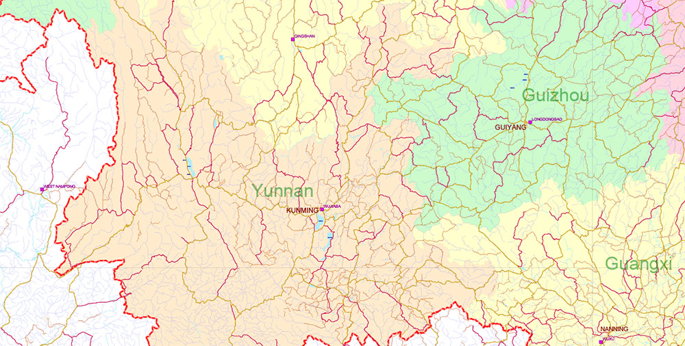
China High Detailed PDF Vector Map: Admin, Roads, Cities and Water areas Editable Layered Adobe PDF

China High Detailed PDF Vector Map: Admin, Roads, Cities and Water areas Editable Layered Adobe PDF

China High Detailed PDF Vector Map: Admin, Roads, Cities and Water areas Editable Layered Adobe PDF

China High Detailed PDF Vector Map: Admin, Roads, Cities and Water areas Editable Layered Adobe PDF

China High Detailed PDF Vector Map: Admin, Roads, Cities and Water areas Editable Layered Adobe PDF

China High Detailed PDF Vector Map: Admin, Roads, Cities and Water areas Editable Layered Adobe PDF

China High Detailed PDF Vector Map: Admin, Roads, Cities and Water areas Editable Layered Adobe PDF

China High Detailed PDF Vector Map: Admin, Roads, Cities and Water areas Editable Layered Adobe PDF

China High Detailed PDF Vector Map: Admin, Roads, Cities and Water areas Editable Layered Adobe PDF

China High Detailed PDF Vector Map: Admin, Roads, Cities and Water areas Editable Layered Adobe PDF

China High Detailed PDF Vector Map: Admin, Roads, Cities and Water areas Editable Layered Adobe PDF
China High Detailed PDF Vector Map: Admin, Roads, Cities and Water areas Editable Layered Adobe PDF

China High Detailed PDF Vector Map: Admin, Roads, Cities and Water areas Editable Layered Adobe PDF

China High Detailed PDF Vector Map: Admin, Roads, Cities and Water areas Editable Layered Adobe PDF

China High Detailed PDF Vector Map: Admin, Roads, Cities and Water areas Editable Layered Adobe PDF

China High Detailed PDF Vector Map: Admin, Roads, Cities and Water areas Editable Layered Adobe PDF

China High Detailed PDF Vector Map: Admin, Roads, Cities and Water areas Editable Layered Adobe PDF

China High Detailed PDF Vector Map: Admin, Roads, Cities and Water areas Editable Layered Adobe PDF

China High Detailed PDF Vector Map: Admin, Roads, Cities and Water areas Editable Layered Adobe PDF

China High Detailed PDF Vector Map: Admin, Roads, Cities and Water areas Editable Layered Adobe PDF

 Author: Kirill Shrayber, Ph.D. FRGS