Extended Description of the Vector Map
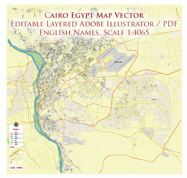
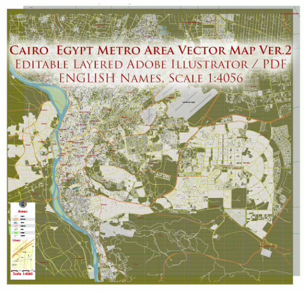
Printable Vector Map of Cairo Metro Area Egypt high detailed scale 1:4065 full editable Adobe Illustrator Street Map in layers, scalable, text / curves format all names (ENGLISH), 18 MB ZIP
All street names, Main Objects, Admin Areas. Map for design, printing, arts, projects, presentations, for architects, designers, and builders, business, logistics.

Layers list:
- Legend
- Grids
- Names of places
- Names Admin Areas
- Names of main streets
- Names of secondary streets
- Arrows of streets
- Main Streets, roads,
- Railroads
- Secondary streets
- Railroads
- Airports and heliports
- Water objects (rivers, lakes, ponds)
- Color fills (parks, hospital areas, land use, etc.)
- Admin Areas
- Background
The most exact and detailed map of the city in scale.
For Editing and High-Quality Printing
Detailed Geographical Description of Cairo, Egypt
Cairo, the capital of Egypt, is one of the most historically and culturally significant cities in the world. Its geographical setting is unique, shaped by its proximity to the Nile River, its desert surroundings, and its position as a crossroads between Africa, Asia, and Europe. Below is a detailed geographical description of Cairo:
1. Location
- Coordinates : Cairo is located at approximately 30.0444° N latitude and 31.2357° E longitude .
- Region : It lies in northeastern Egypt , in the northern part of the African continent.
- Proximity to Key Features :
- The city is situated on the banks of the Nile River , specifically near the apex of the Nile Delta , where the river splits into multiple distributaries before emptying into the Mediterranean Sea.
- It is close to the Eastern Desert to the east and the Western Desert (part of the Sahara) to the west.
- Cairo is approximately 165 kilometers (103 miles) south of the Mediterranean coast and about 120 kilometers (75 miles) west of the Suez Canal.
2. Topography
- Elevation : Cairo sits at an average elevation of 23 meters (75 feet) above sea level. However, its elevation varies slightly across the city due to its sprawling layout.
- Terrain :
- The city is located on a flat plain formed by the Nile’s alluvial deposits, which have created fertile land suitable for agriculture.
- To the east, the terrain rises sharply toward the Muqattam Hills , a limestone ridge that forms a natural boundary for the city.
- To the west, the arid Western Desert stretches out, with sand dunes and rocky plateaus dominating the landscape.
- The Nile Valley itself is relatively narrow in this region, flanked by desert on both sides.
3. Climate
- Type : Cairo has a hot desert climate (BWh) according to the Köppen climate classification.
- Temperature :
- Summers (June to August) are extremely hot, with daytime temperatures often exceeding 40°C (104°F) .
- Winters (December to February) are mild, with daytime highs averaging around 20°C (68°F) and nighttime lows dropping to 10°C (50°F) .
- Precipitation : Rainfall is minimal, averaging only about 25 mm (1 inch) annually. Most rain falls during the winter months, but it is rare and sporadic.
- Humidity : Despite its desert location, Cairo experiences moderate humidity levels due to its proximity to the Nile and the Mediterranean Sea.
4. Hydrography
- The Nile River :
- The Nile is the lifeblood of Cairo, providing water for drinking, irrigation, and transportation.
- The river flows from south to north through the city, dividing it into two main sections: the eastern and western banks.
- Several islands lie within the Nile in Cairo, including Gezira Island (home to the upscale Zamalek district) and Rodah Island .
- Canals and Waterways :
- A network of canals branches off from the Nile, supporting agriculture and urban water needs.
- The Ismailia Canal , which connects the Nile to the Suez Canal, passes near Cairo.
5. Urban Layout
- City Structure :
- Cairo is a sprawling metropolis, spreading over an area of approximately 3,085 square kilometers (1,191 square miles) .
- The city is divided into several distinct zones:
- Old Cairo (Coptic Cairo) : Located in the southern part of the city, this area is home to ancient Christian churches, monasteries, and historic sites.
- Islamic Cairo : Situated in the heart of the city, this district contains numerous mosques, madrasas, and medieval architecture.
- Downtown Cairo : The modern core of the city, featuring wide boulevards, government buildings, and commercial hubs.
- New Cairo : A rapidly developing suburban area to the east, characterized by residential compounds, universities, and business parks.
- Giza : Technically a separate governorate, Giza is closely linked to Cairo and includes the famous Pyramids and the Sphinx.
- Population Density : Cairo is one of the most densely populated cities in Africa, with over 20 million people in its metropolitan area.
6. Natural Resources
- Agriculture :
- The fertile Nile Valley supports the cultivation of crops such as wheat, maize, cotton, and sugarcane.
- Irrigation systems allow for year-round farming despite the arid climate.
- Minerals :
- The surrounding deserts contain deposits of limestone, sandstone, and other minerals, which are used in construction and industry.
7. Environmental Challenges
- Air Pollution :
- Cairo suffers from severe air pollution due to vehicle emissions, industrial activities, and dust storms from the surrounding deserts.
- Water Scarcity :
- Rapid population growth and climate change pose challenges to the availability of clean water, despite the presence of the Nile.
- Urban Sprawl :
- Unplanned expansion into the desert threatens agricultural land and increases pressure on infrastructure.
8. Significance as a Geographic Hub
- Strategic Location :
- Cairo’s position near the Nile Delta and the Suez Canal makes it a vital link between Africa, Asia, and Europe.
- Historically, it served as a trade and cultural center connecting the Mediterranean world with sub-Saharan Africa and the Middle East.
- Transportation :
- Cairo is a major transportation hub, with the Cairo International Airport , extensive road networks, and rail connections to other parts of Egypt and beyond.
Conclusion
Cairo’s geography is defined by its relationship with the Nile River, its desert surroundings, and its role as a bridge between continents. The city’s flat terrain, fertile soil, and strategic location have made it a center of human activity for millennia. However, modern challenges such as pollution, water scarcity, and urbanization highlight the need for sustainable development to preserve this historic and dynamic metropolis.

Cairo Metro Area Egypt Vector Map High Detailed Street Map (ENGLISH NAMES) Adobe Illustrator in layers

Cairo Metro Area Egypt Vector Map High Detailed Street Map (ENGLISH NAMES) Adobe Illustrator in layers

Cairo Metro Area Egypt Vector Map High Detailed Street Map (ENGLISH NAMES) Adobe Illustrator in layers

Cairo Metro Area Egypt Vector Map High Detailed Street Map (ENGLISH NAMES) Adobe Illustrator in layers

Cairo Metro Area Egypt Vector Map High Detailed Street Map (ENGLISH NAMES) Adobe Illustrator in layers

Cairo Metro Area Egypt Vector Map High Detailed Street Map (ENGLISH NAMES) Adobe Illustrator in layers

Cairo Metro Area Egypt Vector Map High Detailed Street Map (ENGLISH NAMES) Adobe Illustrator in layers

Cairo Metro Area Egypt Vector Map High Detailed Street Map (ENGLISH NAMES) Adobe Illustrator in layers

Cairo Metro Area Egypt Vector Map High Detailed Street Map (ENGLISH NAMES) Adobe Illustrator in layers

Cairo Metro Area Egypt Vector Map High Detailed Street Map (ENGLISH NAMES) Adobe Illustrator in layers

Cairo Metro Area Egypt Vector Map High Detailed Street Map (ENGLISH NAMES) Adobe Illustrator in layers

Cairo Metro Area Egypt Vector Map High Detailed Street Map (ENGLISH NAMES) Adobe Illustrator in layers

Cairo Metro Area Egypt Vector Map High Detailed Street Map (ENGLISH NAMES) Adobe Illustrator in layers

Cairo Metro Area Egypt Vector Map High Detailed Street Map (ENGLISH NAMES) Adobe Illustrator in layers

Cairo Metro Area Egypt Vector Map High Detailed Street Map (ENGLISH NAMES) Adobe Illustrator in layers

Cairo Metro Area Egypt Vector Map High Detailed Street Map (ENGLISH NAMES) Adobe Illustrator in layers

Cairo Metro Area Egypt Vector Map High Detailed Street Map (ENGLISH NAMES) Adobe Illustrator in layers

Cairo Metro Area Egypt Vector Map High Detailed Street Map (ENGLISH NAMES) Adobe Illustrator in layers

Cairo Metro Area Egypt Vector Map High Detailed Street Map (ENGLISH NAMES) Adobe Illustrator in layers

Cairo Metro Area Egypt Vector Map High Detailed Street Map (ENGLISH NAMES) Adobe Illustrator in layers

Cairo Metro Area Egypt Vector Map High Detailed Street Map (ENGLISH NAMES) Adobe Illustrator in layers

Cairo Metro Area Egypt Vector Map High Detailed Street Map (ENGLISH NAMES) Adobe Illustrator in layers

Cairo Metro Area Egypt Vector Map High Detailed Street Map (ENGLISH NAMES) Adobe Illustrator in layers

Cairo Metro Area Egypt Vector Map High Detailed Street Map (ENGLISH NAMES) Adobe Illustrator in layers


 Author: Kirill Shrayber, Ph.D. FRGS
