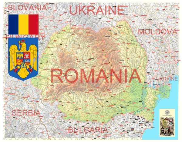
Romania is a country located in Southeastern Europe, and it is known for its rich history, diverse landscapes, and vibrant culture.
Vectormap.Net provide you with the most accurate and up-to-date vector maps in Adobe Illustrator, PDF and other formats, designed for editing and printing. Please read the vector map descriptions carefully.
Here is a detailed description of some of the main cities, ports, towns, and principal roads in Romania:
Main Cities:
- Bucharest:
- The capital and largest city of Romania.
- Known for its impressive architecture, including the Palace of the Parliament, which is one of the largest buildings in the world.
- Cultural attractions include the Village Museum, the National Museum of Art, and the Athenaeum.
- Cluj-Napoca:
- A major city in Transylvania, known for its historical architecture and vibrant cultural scene.
- Home to Babes-Bolyai University, one of the largest and oldest universities in Romania.
- Timișoara:
- Often referred to as the “City of Roses” or the “Little Vienna.”
- Significant for its role in the 1989 Revolution, which led to the fall of the Communist regime in Romania.
- Iași:
- The cultural and academic center of northeastern Romania.
- Features historical landmarks such as the Palace of Culture and the Metropolitan Cathedral.
- Constanța:
- Romania’s largest and most important port city, located on the Black Sea coast.
- A major economic hub with a rich history, including ancient ruins and the Casino building.
- Brasov:
- Situated in the Carpathian Mountains, known for its medieval architecture and picturesque surroundings.
- A gateway to the ski resorts in the region and close to the famous Bran Castle.
Ports:
- Port of Constanța:
- The largest port in Romania and one of the largest on the Black Sea.
- Handles a significant portion of Romania’s imports and exports.
Towns:
- Sibiu:
- A medieval town in Transylvania, known for its well-preserved historic center.
- Designated as the European Capital of Culture in 2007.
- Sighișoara:
- A UNESCO World Heritage Site, known for its well-preserved medieval architecture.
- Birthplace of Vlad the Impaler, the historical figure associated with the Dracula legend.
- Târgu Mureș:
- A city with a mix of Romanian and Hungarian influences, reflecting the cultural diversity in the region.
Principal Roads:
- A1 Motorway:
- Connects Bucharest to the western part of the country, passing through cities like Pitești, Sibiu, and Timișoara.
- A2 Motorway:
- Connects Bucharest to the Black Sea coast, passing through cities like Constanța.
- E60 Road:
- A major European route that crosses Romania from the south to the north, connecting Bucharest to Oradea.
These descriptions provide just a snapshot of the many cities, ports, towns, and roads in Romania. The country’s diverse geography and rich history make it a fascinating destination with much to explore.


 Author: Kirill Shrayber, Ph.D. FRGS