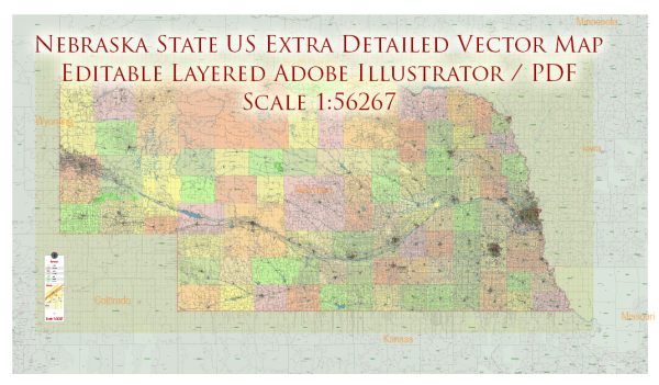
Nebraska, located in the Great Plains region of the United States, is known for its vast expanses of prairies and agricultural landscapes.
Vectormap.Net provide you with the most accurate and up-to-date vector maps in Adobe Illustrator, PDF and other formats, designed for editing and printing. Please read the vector map descriptions carefully.
Here is a detailed description of some of the main cities and towns, as well as principal roads in Nebraska:
Main Cities and Towns:
- Omaha:
- Located on the eastern border of Nebraska, Omaha is the largest city in the state.
- It is a major economic hub with a diverse economy, including finance, healthcare, and telecommunications.
- Attractions include the Henry Doorly Zoo and Aquarium, Old Market district, and the Bob Kerrey Pedestrian Bridge.
- Lincoln:
- As the state capital, Lincoln is situated in the southeastern part of Nebraska.
- It is home to the University of Nebraska and has a vibrant cultural scene with museums, theaters, and historic sites.
- The Nebraska State Capitol, Sunken Gardens, and the University of Nebraska’s campuses are notable landmarks.
- Bellevue:
- A suburb of Omaha, Bellevue is located in the eastern part of the state.
- Offutt Air Force Base, a significant military installation, is situated here.
- Fontenelle Forest and the Sarpy County Museum are notable attractions.
- Grand Island:
- Positioned in the central part of the state, Grand Island is a regional center for agriculture and industry.
- It hosts the Nebraska State Fair and is known for its parks, including Stuhr Museum of the Prairie Pioneer.
- Kearney:
- Located along the Platte River, Kearney is known for its agricultural and educational institutions.
- The Great Platte River Road Archway Monument and the Museum of Nebraska Art are popular attractions.
- Fremont:
- Situated to the northwest of Omaha, Fremont is an important city in Dodge County.
- Fremont is known for its historic downtown area and the proximity to Fremont Lakes State Recreation Area.
Principal Roads:
- Interstate 80 (I-80):
- Running from the western border to the eastern border, I-80 is a major east-west highway connecting cities like Omaha and Lincoln.
- It is a crucial transportation route for both commercial and passenger vehicles.
- Interstate 29 (I-29):
- Serving the eastern border of Nebraska, I-29 connects Omaha to cities in Iowa and the northern United States.
- U.S. Route 83 (US 83):
- Running through the central part of the state, US 83 connects North Platte, Valentine, and other towns.
- U.S. Route 6 (US 6):
- Known as the Grand Army of the Republic Highway, US 6 traverses Nebraska from west to east, passing through cities like Hastings and Lincoln.
- U.S. Route 20 (US 20):
- Running along the northern part of the state, US 20 connects Chadron, Valentine, and O’Neill.
- U.S. Route 30 (US 30):
- Following the historic Lincoln Highway route, US 30 crosses Nebraska from west to east, passing through cities like Sidney, North Platte, and Grand Island.
These are just a few examples, and Nebraska has an extensive network of state highways and local roads connecting its cities and towns. The state’s landscape is characterized by vast prairies, rolling hills, and the Platte River, making it a unique part of the American Midwest.


 Author: Kirill Shrayber, Ph.D. FRGS