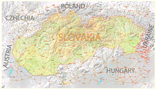
Slovakia, a landlocked country in Central Europe, is known for its picturesque landscapes, historic towns, and rich cultural heritage. Here’s a brief description of some of Slovakia’s principal cities, major waterways, and main roads:
Principal Cities:
- Bratislava:
- The capital and largest city of Slovakia.
- Situated on the banks of the Danube River.
- Known for its medieval old town, historic architecture, and the impressive Bratislava Castle.
- Cultural and economic center with a vibrant atmosphere.
- Košice:
- The second-largest city in Slovakia.
- Located in the eastern part of the country.
- Features well-preserved historical sites, including St. Elisabeth Cathedral and the Urban Tower.
- Known for its cultural events and festivals.
- Žilina:
- A city in northwestern Slovakia.
- Notable for its medieval castle and the Church of St. Paul the Apostle.
- An important industrial and economic center.
- Nitra:
- One of the oldest cities in Slovakia.
- Known for Nitra Castle, the Agrokomplex exhibition center, and the Nitra Synagogue.
- Historically significant as the seat of the first Christian bishopric in Slovakia.
Waterways:
- Danube River:
- One of the major rivers in Europe.
- Flows through Bratislava, forming part of the border with Austria.
- Important for transportation and tourism.
- Váh River:
- The longest river entirely within Slovakia.
- Flows through the cities of Žilina and Trenčín.
- A significant waterway for transportation and recreation.
Main Roads:
- D1 Motorway:
- Connects Bratislava with Žilina and continues to the Polish border.
- One of the most important and heavily trafficked highways in Slovakia.
- D2 Motorway:
- Connects Bratislava with the Czech border.
- An essential route for both domestic and international transportation.
- R1 Expressway:
- Connects Bratislava with Banská Bystrica.
- Part of the European route E58.
- I/18 Road:
- Connects Košice with Žilina, passing through major towns and cities.
- An important east-west road in Slovakia.
- I/64 Road:
- Connects Bratislava with Nitra and continues towards Zvolen.
- An essential route in the western and central parts of the country.
These cities, waterways, and roads contribute to Slovakia’s economic development, tourism, and cultural heritage, creating a diverse and dynamic landscape.
Vectormap.Net provide you with the most accurate and up-to-date vector maps in Adobe Illustrator, PDF and other formats, designed for editing and printing. Please read the vector map descriptions carefully.


 Author: Kirill Shrayber, Ph.D. FRGS