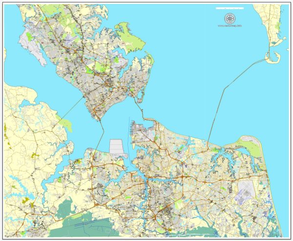
The transportation system in the Hampton Roads region of Virginia, which includes Newport News, Norfolk, Chesapeake, Portsmouth, and Virginia Beach, is characterized by a variety of modes of transportation to accommodate the needs of residents, businesses, and visitors. Here’s a general overview:
- Roads and Highways:
- The area is well-connected with a network of highways and roads, including Interstate 64 (I-64) that runs east-west through the region.
- Other major roads and expressways facilitate intra-city and inter-city travel.
- Bridges and Tunnels:
- Due to the region’s location on the Atlantic Ocean and its numerous waterways, a system of bridges and tunnels is essential for transportation. Examples include the Hampton Roads Bridge-Tunnel and the Monitor-Merrimac Memorial Bridge-Tunnel.
- Public Transit:
- Hampton Roads Transit (HRT) operates bus services throughout the region, providing a means of public transportation for residents and visitors.
- The Tide, a light rail system, serves Norfolk and provides an alternative mode of transit.
- Rail Transportation:
- Norfolk Southern and CSX Transportation operate freight rail services in the region.
- Amtrak provides passenger rail service, connecting the area to other cities along the East Coast.
- Ports:
- The Port of Virginia, with facilities in Norfolk, is a major gateway for international trade. It handles containerized cargo, bulk cargo, and is a key hub for global shipping.
- Airports:
- Norfolk International Airport is the primary airport serving the region, offering domestic and limited international flights.
- Newport News/Williamsburg International Airport also provides air travel services.
- Waterways:
- The Elizabeth River and the Chesapeake Bay play a crucial role in the region’s transportation, supporting maritime commerce and transportation.
- Cycling and Pedestrian Infrastructure:
- Efforts have been made to improve cycling and pedestrian infrastructure, with the development of trails, bike lanes, and walkable areas.
- Military Presence:
- The region is home to several military installations, including Naval Station Norfolk, which significantly influences transportation planning and infrastructure.
- Technology and Innovation:
- Ongoing efforts are being made to incorporate technology and innovation into the transportation system, such as intelligent transportation systems and smart traffic management.
The transportation system in Hampton Roads is designed to accommodate the diverse needs of its residents and the various industries that contribute to its economy, with an emphasis on connectivity given the region’s geographical and economic significance.


 Author: Kirill Shrayber, Ph.D. FRGS