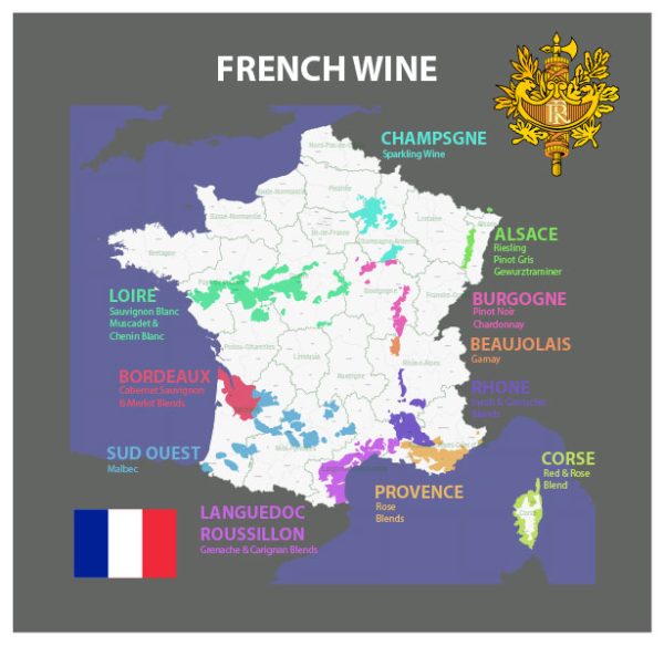
In France, wine regions are often associated with specific rivers that traverse or border the vineyards. Here are some of the principal rivers in key French wine regions:
- Bordeaux:
- Gironde River: The Gironde estuary is formed by the confluence of the Garonne and Dordogne rivers. The Bordeaux region is divided into the Left Bank (west of the Gironde) and the Right Bank (east of the Gironde).
- Burgundy:
- Saône River: The Saône River runs through the Burgundy region. The Côte d’Or, which includes the renowned vineyards of the Côte de Nuits and Côte de Beaune, is situated to the east of the Saône River.
- Rhône Valley:
- Rhône River: The Rhône River is central to the Rhône Valley wine region. The vineyards are located on both the left and right banks of the river.
- Loire Valley:
- Loire River: The Loire Valley is named after the Loire River, and it is one of the most diverse wine regions in France. The vineyards stretch along the Loire and its tributaries.
- Alsace:
- Rhine River: While not entirely in France, the Alsace wine region is located along the eastern border, near the Rhine River, which separates France and Germany.
- Champagne:
- Marne River: The Marne River is a tributary of the Seine and flows through the Champagne region. The vineyards are often located on the slopes overlooking the river.
- Languedoc-Roussillon:
- Gard and Hérault Rivers: These rivers, along with others, traverse the Languedoc-Roussillon region, which is one of the largest wine-producing regions in France.
- Provence:
- Rhone River: Provence is influenced by the Rhône River, which runs through the region. The vineyards benefit from the Mediterranean climate.
Remember that these rivers are just one aspect of the complex terroir that contributes to the unique characteristics of wines from each region. The combination of soil, climate, grape varieties, and winemaking traditions also plays a significant role in shaping the final product.


 Author: Kirill Shrayber, Ph.D. FRGS