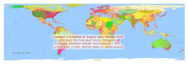
The Lambert cylindrical equal-area projection, commonly known as Lambert’s projection, is an equal-area map projection. While it aims to preserve the relative sizes of areas, it introduces distortions in other aspects. Here are some problems and distortions associated with Lambert’s projection:
- Shape Distortion: Similar to many cylindrical projections, Lambert’s projection exhibits shape distortion, particularly as one moves away from the equator. This distortion becomes more pronounced towards the poles, where features appear stretched or compressed horizontally.
- Distance Distortion: The projection distorts distances, especially as you move away from the standard parallel (the latitude where scale is true). Distances are generally accurate along the standard parallel but become increasingly distorted towards the poles.
- Direction Distortion: Like other cylindrical projections, Lambert’s projection suffers from direction distortion. The angles and bearings between locations are not accurately represented on the map, particularly away from the standard parallel.
- Pole Issues: Lambert’s projection is not suitable for mapping polar regions due to extreme distortion. The poles are either omitted or represented with severe distortion, making it impractical for mapping high-latitude areas.
- Limited for Navigation: Lambert’s projection, despite being equal-area, is not ideal for navigation purposes. Navigators often prefer conformal projections that preserve angles and shapes for accurate navigation.
- Map Size: The map extends indefinitely in the east-west direction, which can result in a distortion of the overall size of features. This characteristic can make it challenging to visualize the entire world in a way that accurately represents its size and shape.
Despite these distortions, Lambert’s projection has its applications, especially in thematic mapping where equal area is a crucial consideration. It is often used for mapping large regions or continents where maintaining an accurate representation of the relative sizes of areas is more important than preserving shapes or distances.


 Author: Kirill Shrayber, Ph.D. FRGS