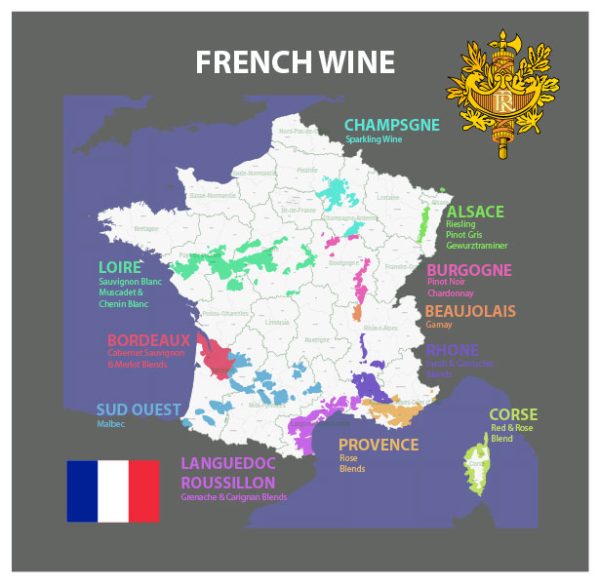
French wine has a rich history and diverse geography, making it one of the most renowned wine-producing countries in the world. Here’s an overview of the history and geography of French wine:
History:
- Ancient Origins: The history of French wine dates back to ancient times. The Greeks introduced grapevines to the region around 600 BC, but it was the Romans who significantly contributed to the development of viticulture in Gaul (ancient France).
- Monasteries and Middle Ages: During the Middle Ages, monasteries played a crucial role in preserving and improving winemaking techniques. They also identified and classified different grape varieties.
- The Royal Influence: The French royal courts further elevated the status of wine. Kings and nobles established vineyards and promoted the production of quality wines.
- Wine Laws and Classification: In the 19th century, the French government implemented wine laws to regulate production and protect the reputation of certain regions. The AOC (Appellation d’Origine Contrôlée) system was established in the early 20th century to define and regulate the geographical origin and production methods of French wines.
Geography:
France is divided into several wine regions, each known for its unique terroir (combination of soil, climate, and topography) and grape varieties. The main wine regions include:
- Bordeaux: Located in the southwest, Bordeaux is known for its red blends, often featuring Cabernet Sauvignon, Merlot, and Cabernet Franc. The region is divided into sub-regions such as Medoc, Pomerol, and Saint-Emilion.
- Burgundy: Situated in eastern France, Burgundy is famous for its Pinot Noir and Chardonnay wines. The region is subdivided into smaller appellations, including Côte de Nuits and Côte de Beaune.
- Champagne: Northeast of Paris, Champagne is renowned for its sparkling wine produced using the traditional method. Only wines from this region can be labeled as Champagne.
- Rhône Valley: This region in the southeast produces a wide range of wines. The northern Rhône is known for Syrah-based wines, while the southern Rhône produces blends featuring Grenache, Syrah, and Mourvèdre.
- Loire Valley: Along the Loire River, this region produces a variety of wines, including Sauvignon Blanc, Chenin Blanc, and Cabernet Franc. It is known for its diverse styles and appellations like Sancerre and Vouvray.
- Alsace: Located in northeastern France, Alsace is known for its aromatic white wines, particularly Riesling and Gewürztraminer.
- Provence: In the southeastern part of France, Provence is famous for its rosé wines, often made from Grenache, Cinsault, and Mourvèdre.
- Languedoc-Roussillon: This region in the south is one of the largest wine-producing areas in France, known for both quality and value wines.
Each of these regions contributes to the overall reputation of French wine, reflecting the diversity and complexity of the country’s viticultural heritage.


 Author: Kirill Shrayber, Ph.D. FRGS