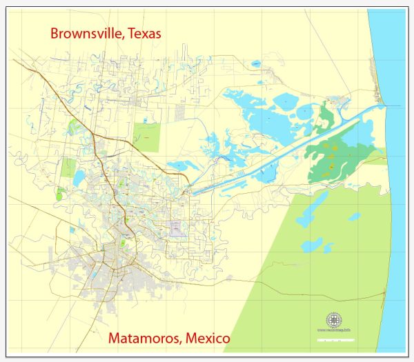
Brownsville, Texas, and Matamoros, Mexico, are neighboring cities located at the southernmost tip of Texas and northern Mexico, respectively. They are situated on the border between the United States and Mexico, separated by the Rio Grande River. Here’s a geographical description of both cities:
Brownsville, Texas:
- Location: Brownsville is in the southern part of the state of Texas, in the United States.
- Border: It is situated on the northern bank of the Rio Grande River, which forms the international border with Matamoros, Tamaulipas, Mexico.
- Gulf of Mexico: Brownsville is located along the Gulf of Mexico coastline, with access to the Gulf through the nearby Port of Brownsville.
- Climate: Brownsville has a subtropical climate with hot and humid summers and mild winters. It is prone to hurricanes and tropical storms due to its proximity to the Gulf of Mexico.
- Vegetation: The region features a mix of subtropical vegetation, including palm trees, native grasses, and shrubs.
- Economy: Brownsville is an important economic hub for trade and commerce, with a focus on international trade due to its proximity to Mexico. It’s also home to various industries and educational institutions.
Matamoros, Mexico:
- Location: Matamoros is in the state of Tamaulipas, Mexico, and is situated directly across the Rio Grande River from Brownsville, Texas.
- Border: Matamoros shares its border with Brownsville and is connected by several international bridges and crossings.
- Gulf of Mexico: Like Brownsville, Matamoros is also located along the Gulf of Mexico coast, which contributes to its economic significance as a port city.
- Climate: Matamoros has a similar subtropical climate to Brownsville, characterized by hot and humid summers and mild winters.
- Vegetation: The region around Matamoros features subtropical flora and fauna, with various species of palm trees, mangroves, and coastal plants.
- Economy: Matamoros is a significant industrial and manufacturing center in Mexico, with a focus on trade and commerce with the United States. The city’s proximity to the U.S. border and its access to the Gulf of Mexico contribute to its economic activity.
These two cities, despite being in different countries, share a unique and interconnected relationship due to their geographical proximity. They have a long history of cross-border trade and cultural exchange, making the Brownsville-Matamoros region a dynamic and diverse area.


 Author: Kirill Shrayber, Ph.D. FRGS