Editable Vector Map of the Wellington New Zealand in SVG format.
Can be edited in the following programs: Adobe Illustrator, CorelDraw, InkScape
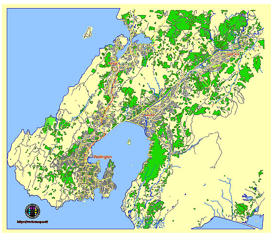
Principal streets and roads, names places, residential streets and roads, road number labels, water objects, land use areas.
Wellington New Zealand editable vector map svg free
DOWNLOAD ARCHIVE FOR FREE >>>
Distributed with Creative Commons CC-Zero = Creative Commons CC0 1.0 Universal Public Domain Dedication International License
SEE ALSO FULL VERSION OF THE Wellington New Zealand vector map (Adobe Illustrator, PDF etc.)
Wellington, the capital city of New Zealand, is known for its vibrant neighborhoods and beautiful landscapes. Here are some principal streets, roads, and districts you should know:
Streets and Roads:
- Lambton Quay: A major street in the central business district (CBD) lined with shops, cafes, and office buildings.
- Willis Street: Runs parallel to Lambton Quay and is another prominent commercial street in Wellington.
- Courtenay Place: Famous for its nightlife, bars, restaurants, and entertainment venues.
- Cuba Street: Known for its bohemian vibe, unique shops, cafes, and street art.
- Victoria Street: Connects the CBD with Te Aro and is lined with restaurants and bars.
- The Terrace: A street on the hillside above Lambton Quay, offering panoramic views of the city and harbor.
- Karori Road: Runs through the suburb of Karori, providing access to residential areas and local amenities.
- Hutt Road: Connects Wellington CBD with the Hutt Valley, passing through areas like Kaiwharawhara and Ngauranga.
City Districts:
- CBD (Central Business District): The heart of Wellington, where most businesses, government offices, and shopping centers are located.
- Te Aro: Known for its cultural diversity, nightlife, and entertainment options, including Cuba Street and Courtenay Place.
- Thorndon: Adjacent to the CBD and home to the New Zealand Parliament buildings and the historic Thorndon area.
- Kelburn: Located near the Wellington Botanic Garden and Victoria University of Wellington, offering residential areas and scenic views.
- Mount Victoria: A suburb known for its hilltop views overlooking the city and harbor, popular for its residential charm.
- Miramar: Known for its film industry (Weta Workshop and Weta Digital), as well as scenic coastal views and suburban living.
- Karori: A residential suburb with schools, parks, and local shops, situated west of the CBD.
- Petone: Across the harbor from Wellington CBD, in Lower Hutt, known for its historical significance and vibrant community.
These areas and streets showcase the diversity and charm of Wellington, offering a blend of urban amenities, natural beauty, and cultural experiences.
 Author: Kirill Shrayber, Ph.D. FRGS