Editable Vector Map of the Tulsa Oklahoma US in SVG format.
Can be edited in the following programs: Adobe Illustrator, CorelDraw, InkScape
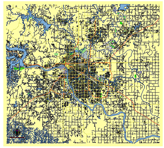
Principal streets and roads, names places, residential streets and roads, road number labels, water objects, land use areas.
Tulsa Oklahoma US editable vector map svg free
DOWNLOAD ARCHIVE FOR FREE >>>
Distributed with Creative Commons CC-Zero = Creative Commons CC0 1.0 Universal Public Domain Dedication International License
SEE ALSO FULL VERSION OF THE Tulsa Oklahoma US vector map (Adobe Illustrator, PDF etc.)
Tulsa, Oklahoma, is known for its vibrant culture, rich history, and distinctive districts. Here’s an overview of some of the principal streets, roads, and notable city districts in Tulsa:
Principal Streets and Roads:
- Peoria Avenue:
- A major north-south thoroughfare running through the city, connecting various neighborhoods and commercial areas.
- Riverside Drive:
- Scenic road along the Arkansas River, popular for recreational activities and views of the river. It runs parallel to River Parks, a series of parks along the river.
- 11th Street (Route 66):
- Part of the historic U.S. Route 66, running east-west through Tulsa and featuring various landmarks and historic sites.
- 21st Street:
- Another significant east-west street known for running through Tulsa’s midtown and residential areas.
- 71st Street:
- A major commercial corridor in South Tulsa, lined with shopping centers, restaurants, and businesses.
- Broken Arrow Expressway (U.S. Route 64):
- A key east-west freeway that connects Tulsa with the suburb of Broken Arrow.
- Interstate 44 (I-44):
- A major interstate highway running northeast-southwest through Tulsa, providing access to various parts of the city and beyond.
- Interstate 244 (I-244):
- An auxiliary interstate forming a loop around downtown Tulsa, known as the Martin Luther King Jr. Memorial Expressway on the north and the Crosstown Expressway on the south.
- U.S. Route 75:
- A north-south highway that cuts through the city, providing access to key areas and connecting Tulsa to other major cities.
- Sheridan Road:
- A significant north-south road running through the city, intersecting with many key east-west streets.
Notable City Districts:
- Downtown Tulsa:
- The central business district featuring historic buildings, high-rise offices, entertainment venues, and cultural attractions such as the BOK Center and the Tulsa Performing Arts Center.
- Brookside:
- A trendy district along South Peoria Avenue known for its boutique shopping, dining, and nightlife.
- Cherry Street (15th Street):
- A vibrant area filled with restaurants, cafes, antique shops, and the Cherry Street Farmers Market.
- Blue Dome District:
- Named after the historic Blue Dome building, this district is known for its nightlife, restaurants, bars, and entertainment venues.
- Brady Arts District (now called the Tulsa Arts District):
- A cultural hub with art galleries, museums (including the Woody Guthrie Center), performance spaces, and a variety of dining options.
- Greenwood District:
- Historically known as “Black Wall Street,” this area is rich in African-American history and heritage, featuring the Greenwood Cultural Center and the John Hope Franklin Reconciliation Park.
- Utica Square:
- A high-end shopping district in midtown Tulsa, featuring upscale stores, boutiques, and restaurants.
- East Village District:
- An up-and-coming area in downtown Tulsa with a mix of residential, commercial, and entertainment spaces.
- Midtown Tulsa:
- A predominantly residential area with tree-lined streets, historic homes, and parks. It is also home to the Philbrook Museum of Art and Woodward Park.
- South Tulsa:
- A suburban area known for its residential neighborhoods, schools, and shopping centers, including Woodland Hills Mall.
These streets and districts are integral parts of Tulsa’s landscape, each contributing to the city’s unique character and offering a variety of experiences for residents and visitors alike.
 Author: Kirill Shrayber, Ph.D. FRGS