Editable Vector Map of the Tampere Finland in SVG format.
Can be edited in the following programs: Adobe Illustrator, CorelDraw, InkScape
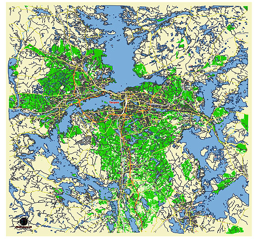
Principal streets and roads, names places, residential streets and roads, road number labels, water objects, land use areas.
Tampere Finland editable vector map svg free
DOWNLOAD ARCHIVE FOR FREE >>>
Distributed with Creative Commons CC-Zero = Creative Commons CC0 1.0 Universal Public Domain Dedication International License
SEE ALSO FULL VERSION OF THE Tampere Finland vector map (Adobe Illustrator, PDF etc.)
Tampere, located in southern Finland, is the third-largest city in the country and a significant urban center. Here are some of the principal streets, roads, and notable cities and towns in the region:
Principal Streets and Roads in Tampere:
- Hämeenkatu: This is the main street in Tampere, running through the city center and lined with shops, restaurants, and important landmarks.
- Itäinenkatu: An important street that connects the eastern parts of the city.
- Satakunnankatu: A significant street known for its proximity to cultural venues and commercial areas.
- Pirkankatu: Runs through the central and western parts of Tampere, leading to the Pyynikki observation tower.
- Teiskontie: A major road that connects central Tampere to the northeastern suburbs.
- Paasikiven-Kekkosentie: A key bypass road facilitating traffic around the city center.
- Rantatunneli: An important tunnel road that helps to alleviate traffic congestion in the city center by providing an alternative route.
Major Roads Connecting Tampere:
- E12: Also known as the “Tampere Motorway,” it connects Tampere to Helsinki and other major cities.
- E63: Runs from Turku through Tampere and continues northward, connecting several Finnish cities.
- Highway 9 (Valtatie 9): Connects Tampere to Turku and Kuopio, facilitating east-west travel.
- Highway 3 (Valtatie 3): Connects Tampere to Helsinki in the south and Vaasa in the north.
Nearby Cities and Towns:
- Nokia: Located southwest of Tampere, known for the multinational telecommunications company.
- Ylöjärvi: A town just northwest of Tampere, known for its beautiful nature and recreational opportunities.
- Pirkkala: A small town located immediately south of Tampere, known for its residential areas and proximity to Tampere-Pirkkala Airport.
- Kangasala: Situated east of Tampere, famous for its lakes and picturesque landscapes.
- Lempäälä: Located southeast of Tampere, known for its historical sites and shopping centers.
- Orivesi: Northeast of Tampere, offering a mix of cultural attractions and natural beauty.
Notable Neighborhoods in Tampere:
- Hervanta: A vibrant neighborhood known for its technological university, multicultural atmosphere, and innovative businesses.
- Kaleva: A central neighborhood with a mix of residential areas and commercial activities.
- Pyynikki: Famous for its ridges and the Pyynikki Observation Tower, offering panoramic views of the city.
- Laukontori: A central square and market area by the Tammerkoski rapids.
These streets, roads, and towns are crucial to the infrastructure and connectivity of Tampere, making it a vital hub in southern Finland.
 Author: Kirill Shrayber, Ph.D. FRGS