Editable Vector Map of the Sioux Falls South Dakota US in SVG format.
Can be edited in the following programs: Adobe Illustrator, CorelDraw, InkScape
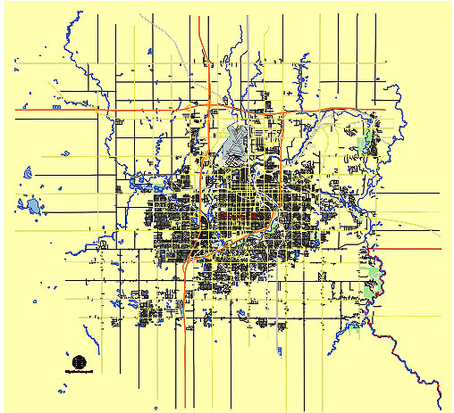
Principal streets and roads, names places, residential streets and roads, road number labels, water objects, land use areas.
Sioux Falls South Dakota US editable vector map svg free
DOWNLOAD ARCHIVE FOR FREE >>>
Distributed with Creative Commons CC-Zero = Creative Commons CC0 1.0 Universal Public Domain Dedication International License
SEE ALSO FULL VERSION OF THE Sioux Falls South Dakota US vector map (Adobe Illustrator, PDF etc.)
Sioux Falls, South Dakota, is a vibrant city with several principal streets, roads, and districts. Here are some of the key ones:
- Downtown Sioux Falls: This area is the heart of the city and includes Phillips Avenue, which is known for its historic buildings, restaurants, shops, and entertainment venues.
- Minnesota Avenue: One of the major north-south thoroughfares running through the city, lined with various businesses and residential areas.
- 41st Street: A significant east-west corridor featuring shopping centers, restaurants, and various commercial developments.
- I-229 (Veterans’ Parkway): This interstate loop connects various parts of Sioux Falls and provides access to major areas within the city.
- West 12th Street: Another important east-west route in Sioux Falls with various commercial and residential developments.
- East 10th Street: Known for its diverse mix of businesses, restaurants, and residential neighborhoods on the east side of the city.
- Western Mall Area: Home to the Western Mall and a variety of retail stores, restaurants, and businesses.
- Empire Mall Area: Anchored by the Empire Mall, one of the largest shopping centers in South Dakota, with numerous retail stores and restaurants nearby.
- East 26th Street: Connecting eastern Sioux Falls with residential neighborhoods, schools, and retail establishments.
- South Louise Avenue: A major road on the south side of the city, known for its commercial developments and access to residential areas.
- Sertoma Park Area: Located along the Big Sioux River, featuring parks, trails, and recreational facilities.
- Falls Park Area: Home to the iconic Falls Park, where the Big Sioux River cascades over a series of rock formations, offering scenic views and walking trails.
These streets, roads, and districts collectively contribute to the diverse and dynamic landscape of Sioux Falls, South Dakota.
 Author: Kirill Shrayber, Ph.D. FRGS