Editable Vector Map of the Shanghai China in SVG format.
Can be edited in the following programs: Adobe Illustrator, CorelDraw, InkScape
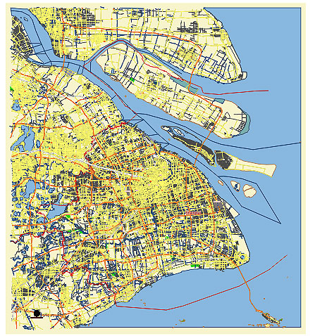
Principal streets and roads, names places, residential streets and roads, road number labels, water objects, land use areas.
Shanghai China editable vector map svg free
DOWNLOAD ARCHIVE FOR FREE >>>
Distributed with Creative Commons CC-Zero = Creative Commons CC0 1.0 Universal Public Domain Dedication International License
SEE ALSO FULL VERSION OF THE Shanghai China vector map (Adobe Illustrator, PDF etc.)
Shanghai, one of China’s largest and most dynamic cities, boasts a variety of notable streets, roads, and districts. Here’s an overview of some key areas:
Principal Streets and Roads
- Nanjing Road (南京路)
- Nanjing East Road: Famous for shopping, it’s a bustling pedestrian street lined with various shops and malls.
- Nanjing West Road: Also a major commercial street, known for its high-end shopping and proximity to Jing’an Temple.
- Huaihai Road (淮海路)
- Known for its luxury boutiques and international brands, Huaihai Road is often compared to Paris’ Champs-Élysées.
- The Bund (外滩)
- A waterfront area along the Huangpu River, famous for its historical colonial-era buildings and a stunning view of the modern skyline of Pudong.
- Yan’an Road (延安路)
- One of the main east-west arteries of the city, known for heavy traffic and its elevated highway.
- Century Avenue (世纪大道)
- Located in Pudong, it is a major thoroughfare that connects several key financial and cultural landmarks.
Major City Districts
- Huangpu District (黄浦区)
- The heart of old Shanghai, encompassing the Bund, Nanjing Road, and People’s Square. It’s a cultural and historical center with numerous landmarks.
- Jing’an District (静安区)
- Known for its blend of modern skyscrapers and traditional Shikumen buildings, as well as the famous Jing’an Temple and commercial areas.
- Xuhui District (徐汇区)
- A historic district with the French Concession area, famous for its tree-lined streets, colonial-era architecture, and vibrant café culture.
- Pudong New Area (浦东新区)
- Home to the city’s financial district, including the iconic Lujiazui skyline with landmarks like the Shanghai Tower, Jin Mao Tower, and Oriental Pearl Tower.
- Changning District (长宁区)
- Known for its residential neighborhoods, international schools, and the bustling Zhongshan Park.
- Minhang District (闵行区)
- A rapidly developing suburban area with a mix of industrial zones, residential areas, and educational institutions.
- Yangpu District (杨浦区)
- Home to several universities and known for its industrial heritage and ongoing urban renewal projects.
- Hongkou District (虹口区)
- A historic area with a rich Jewish heritage, known for its cultural venues like the Shanghai Jewish Refugees Museum and Lu Xun Park.
Iconic Landmarks and Areas
- Lujiazui (陆家嘴)
- The financial hub in Pudong, characterized by its towering skyscrapers and modern architecture.
- Xintiandi (新天地)
- A trendy entertainment and shopping area in the French Concession, known for its nightlife and preserved Shikumen buildings.
- Tianzifang (田子坊)
- A famous arts and crafts enclave in the French Concession, featuring narrow alleyways filled with boutiques, cafes, and art studios.
- People’s Square (人民广场)
- A large public square in Huangpu District, surrounded by important buildings like the Shanghai Museum, Shanghai Grand Theatre, and the Urban Planning Exhibition Hall.
- Zhujiajiao (朱家角)
- An ancient water town on the outskirts of Shanghai, known for its well-preserved Ming and Qing dynasty architecture and picturesque canals.
These streets and districts highlight the diverse and multifaceted character of Shanghai, blending historical heritage with modern dynamism.
 Author: Kirill Shrayber, Ph.D. FRGS