Editable Vector Map of the Seattle and Bellevue Washington US in SVG format.
Can be edited in the following programs: Adobe Illustrator, CorelDraw, InkScape
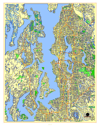
Principal streets and roads, names places, residential streets and roads, road number labels, water objects, land use areas.
Seattle and Bellevue Washington US editable vector map svg free
DOWNLOAD ARCHIVE FOR FREE >>>
Distributed with Creative Commons CC-Zero = Creative Commons CC0 1.0 Universal Public Domain Dedication International License
Seattle, Washington
Principal Streets and Roads:
- 1st Avenue – A major north-south arterial through downtown Seattle.
- 2nd Avenue – Runs parallel to 1st Avenue, also a significant downtown thoroughfare.
- 3rd Avenue – Another key north-south route through the downtown area.
- 4th Avenue – Serves downtown Seattle and is a major route for public transportation.
- 5th Avenue – Extends through downtown Seattle, known for shops and theaters.
- 6th Avenue – Runs through the central business district and Belltown.
- Pike Street – A major east-west street, famous for Pike Place Market.
- Pine Street – Another significant east-west street, crossing through downtown.
- Denny Way – Connects Capitol Hill to Seattle Center and Belltown.
- Broadway – A major north-south street in Capitol Hill.
- Rainier Avenue South – A key south Seattle arterial, passing through several neighborhoods.
- Aurora Avenue North (State Route 99) – A major north-south route, passing through downtown and continuing north.
- Alaskan Way – Runs along the waterfront, parallel to the Alaskan Way Viaduct.
- Lake City Way NE – A primary north-south route in northeast Seattle.
- Ravenna Boulevard – Connects several neighborhoods, known for its greenery.
- Greenwood Avenue North – Runs through the Greenwood and Phinney Ridge neighborhoods.
City Districts:
- Downtown – The central business district, home to major businesses, shopping, and entertainment.
- Pioneer Square – Historic district known for its nightlife and art galleries.
- Belltown – Vibrant neighborhood with nightlife, dining, and residential spaces.
- Capitol Hill – Known for its bohemian vibe, nightlife, and LGBTQ+ community.
- South Lake Union – Hub of tech companies, including Amazon’s headquarters.
- Fremont – Quirky neighborhood known for its arts scene and the Fremont Troll.
- Ballard – Maritime neighborhood with Scandinavian heritage and a thriving food scene.
- Queen Anne – Residential area with views of the Space Needle and Seattle skyline.
- West Seattle – Includes Alki Beach and offers a more suburban feel.
- University District – Home to the University of Washington, with a student-driven atmosphere.
- International District (Chinatown-International District) – Cultural hub with diverse Asian restaurants and shops.
Bellevue, Washington
Principal Streets and Roads:
- Main Street – Runs east-west through downtown Bellevue, lined with shops and restaurants.
- NE 8th Street – Major east-west thoroughfare through Bellevue, connecting downtown with the rest of the city.
- Bellevue Way NE – North-south route that serves as a major arterial through downtown.
- 148th Avenue NE – A significant north-south route connecting various neighborhoods.
- Factoria Boulevard SE – Serves the Factoria area, a key commercial district.
- 116th Avenue NE – Runs parallel to Interstate 405, connecting various neighborhoods.
- 164th Avenue NE – A major north-south road in the Crossroads neighborhood.
- Lake Washington Boulevard SE – Scenic route along the lake, connecting Bellevue to Renton.
- Richards Road – North-south route serving the Eastgate neighborhood.
- Coal Creek Parkway SE – Runs southeast from Bellevue, connecting to Newcastle.
City Districts:
- Downtown Bellevue – The city’s central business district, with high-rises, shopping, and dining.
- Crossroads – Diverse neighborhood known for its shopping center and multicultural community.
- Factoria – Commercial district with shopping centers, office parks, and residential areas.
- Eastgate – Residential area with easy access to I-90 and the Bellevue College campus.
- Wilburton – Residential and commercial area east of downtown, home to the Bellevue Botanical Garden.
- West Bellevue – Upscale residential neighborhood with large homes and proximity to the lake.
- Bridle Trails – Equestrian-friendly neighborhood with large lots and horse trails.
- Newport – Residential area in south Bellevue, known for good schools and family-friendly environment.
- Somerset – Residential community on a hill, offering panoramic views of the region.
- Woodridge – Suburban neighborhood with parks and recreational facilities.
These streets, roads, and districts form the backbone of Seattle and Bellevue, offering a mix of commercial, residential, and cultural hubs.
 Author: Kirill Shrayber, Ph.D. FRGS