Editable Vector Map of the Salt Lake City Utah US in SVG format.
Can be edited in the following programs: Adobe Illustrator, CorelDraw, InkScape
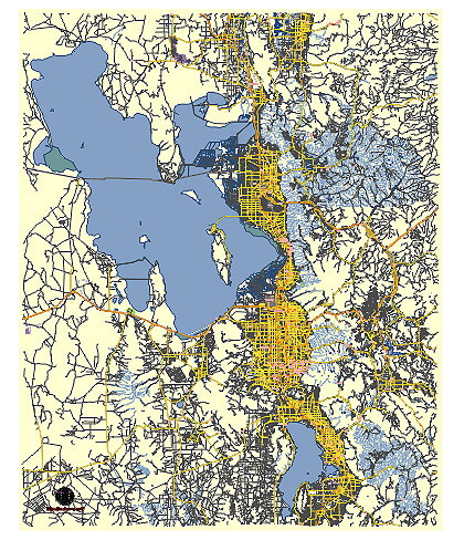
Principal streets and roads, names places, residential streets and roads, road number labels, water objects, land use areas.
Salt Lake City Utah US editable vector map svg free
DOWNLOAD ARCHIVE FOR FREE >>>
Distributed with Creative Commons CC-Zero = Creative Commons CC0 1.0 Universal Public Domain Dedication International License
SEE ALSO FULL VERSION OF THE Salt Lake City Utah US vector map (Adobe Illustrator, PDF etc.)
Salt Lake City, the capital of Utah, has several prominent streets, roads, and districts that define its landscape. Here’s a detailed overview:
Principal Streets and Roads
- State Street (U.S. Route 89):
- A major north-south route that runs through the heart of Salt Lake City.
- Passes by key landmarks like the Utah State Capitol and downtown business district.
- Main Street:
- Central to the downtown area, known for historic buildings, shops, restaurants, and cultural attractions.
- Connects the Capitol Theatre and the City Creek Center.
- Temple Square:
- Although not a street, it is a central block around which the city is oriented.
- Features the Salt Lake Temple and other important buildings of the Church of Jesus Christ of Latter-day Saints.
- 400 South (University Boulevard):
- A major east-west thoroughfare that connects downtown to the University of Utah.
- Known for its academic buildings and student housing areas.
- 700 East:
- A key north-south route that cuts through various residential neighborhoods and commercial areas.
- It transitions to Foothill Drive further south, providing access to the Bonneville Shoreline Trail and the Hogle Zoo.
- Foothill Drive:
- Extends southeast from the University of Utah to connect with I-215.
- Provides access to the East Bench and foothill neighborhoods.
- I-15 and I-80:
- Major interstates intersecting in Salt Lake City, facilitating regional and interstate travel.
- I-15 runs north-south while I-80 runs east-west.
- 400 West (North Temple):
- An important commercial corridor that hosts the Utah State Fairpark and various businesses.
- Connects to the Salt Lake City International Airport.
City Districts
- Downtown:
- The central business district with a mix of office buildings, shopping centers, restaurants, and nightlife.
- Includes landmarks such as Temple Square, the Salt Palace Convention Center, and City Creek Center.
- Sugar House:
- A historic neighborhood known for its vibrant commercial district, parks, and residential areas.
- Sugar House Park and Westminster College are notable landmarks.
- The Avenues:
- A primarily residential area with a mix of historic homes and newer constructions.
- Known for its grid-like street pattern and proximity to downtown.
- Capitol Hill:
- Home to the Utah State Capitol building and some of the city’s oldest neighborhoods.
- Offers panoramic views of the city and surrounding mountains.
- University of Utah:
- Centered around the university campus, this area includes academic buildings, research centers, and student housing.
- The Natural History Museum of Utah and the Red Butte Garden are nearby attractions.
- Rose Park:
- A diverse residential community in the northwest part of the city.
- Known for its parks and family-friendly environment.
- Liberty Wells:
- A neighborhood south of downtown, named after Liberty Park, which is the city’s largest park.
- Features a mix of early 20th-century homes and newer developments.
- East Bench:
- An affluent area located along the foothills of the Wasatch Range.
- Offers upscale homes and scenic views, with easy access to outdoor activities.
- Glendale:
- A diverse community in the southwestern part of Salt Lake City.
- Known for its parks and recreational facilities like the Jordan River Parkway.
Each of these streets and districts contributes to the unique character and functionality of Salt Lake City, making it a vibrant and dynamic urban area.
 Author: Kirill Shrayber, Ph.D. FRGS