Editable Vector Map of the Salem Oregon US in SVG format.
Can be edited in the following programs: Adobe Illustrator, CorelDraw, InkScape
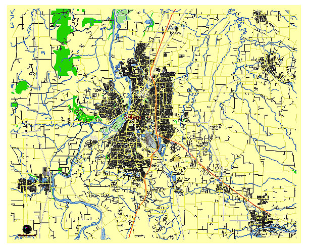
Principal streets and roads, names places, residential streets and roads, road number labels, water objects, land use areas.
Salem Oregon US editable vector map svg free
DOWNLOAD ARCHIVE FOR FREE >>>
Distributed with Creative Commons CC-Zero = Creative Commons CC0 1.0 Universal Public Domain Dedication International License
SEE ALSO FULL VERSION OF THE Salem Oregon US vector map (Adobe Illustrator, PDF etc.)
Salem, the capital city of Oregon, has several notable streets, roads, and districts. Here’s a rundown of some of the key ones:
Principal Streets and Roads
- Commercial Street:
- A major north-south arterial street running through downtown Salem, filled with shops, restaurants, and historic buildings.
- Liberty Street:
- Parallel to Commercial Street, Liberty Street is another significant road through downtown with a mix of businesses and government buildings.
- Lancaster Drive:
- A busy thoroughfare in northeast Salem, lined with shopping centers, restaurants, and other commercial establishments.
- Center Street:
- Running east-west, Center Street connects the downtown area to the east side of Salem, including the Oregon State Capitol.
- State Street:
- Another major east-west road, passing through downtown and providing access to the Capitol and Willamette University.
- Wallace Road:
- Located in West Salem, this road is important for accessing residential areas and local businesses.
- Mission Street:
- Connecting to the south, this street leads towards Salem Hospital and Bush’s Pasture Park.
- Silverton Road:
- Extending northeast, Silverton Road leads out of the city towards the rural areas and the town of Silverton.
Principal City Districts
- Downtown District:
- The heart of Salem, featuring government buildings like the Oregon State Capitol, as well as a variety of shops, restaurants, and cultural attractions.
- Capitol Mall:
- Centered around the State Capitol building and Capitol State Park, this area is a focal point for government activity and public events.
- West Salem:
- Located across the Willamette River, West Salem is primarily residential with some commercial areas. It includes the scenic Wallace Marine Park.
- South Salem:
- A residential area known for its schools, parks, and suburban feel, extending towards the hills south of the city.
- Northeast Salem:
- A diverse district with a mix of residential, commercial, and industrial areas. Lancaster Drive is a key commercial corridor here.
- Southeast Salem:
- Predominantly residential, this area includes several parks and schools, as well as the historic Deepwood Estate.
- North Salem:
- A mix of residential and commercial areas, with important roads like Portland Road and Silverton Road providing access to and from the city.
These streets and districts form the backbone of Salem, connecting its diverse neighborhoods and providing a variety of amenities and services to residents and visitors alike.
 Author: Kirill Shrayber, Ph.D. FRGS