Editable Vector Map of the Perth Australia in SVG format.
Can be edited in the following programs: Adobe Illustrator, CorelDraw, InkScape
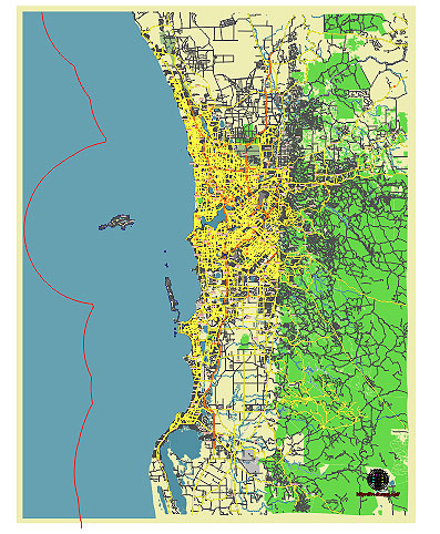
Principal streets and roads, names places, residential streets and roads, road number labels, water objects, land use areas.
Perth Australia vector map svg free
DOWNLOAD ARCHIVE FOR FREE >>>
Distributed with Creative Commons CC-Zero = Creative Commons CC0 1.0 Universal Public Domain Dedication International License
SEE ALSO FULL VERSION OF THE Perth Australia vector map (Adobe Illustrator, PDF etc.)
Perth, the capital city of Western Australia, is known for its vibrant culture, beautiful landscapes, and bustling urban life. Here are some of the principal streets, roads, and city districts of Perth:
Principal Streets and Roads
- St George’s Terrace: This is the main commercial street in Perth’s central business district (CBD). It’s home to many office buildings, banks, and corporate headquarters.
- Hay Street: Running parallel to St George’s Terrace, Hay Street is another major thoroughfare in the CBD, known for its shopping precincts, cafes, and historic buildings.
- Murray Street: This street is a bustling retail area with a variety of shops, restaurants, and entertainment options.
- William Street: William Street stretches through the CBD and Northbridge, featuring a mix of cultural, dining, and nightlife spots.
- Beaufort Street: Extending from the CBD to the northern suburbs, Beaufort Street is lined with cafes, bars, boutiques, and is a popular dining destination.
- Canning Highway: This major road connects Perth with Fremantle and runs along the southern side of the Swan River, providing scenic views and access to riverside suburbs.
- Mitchell Freeway: A key freeway in Perth that runs north-south through the city, linking northern suburbs with the CBD.
- Kwinana Freeway: Running south from the CBD, this freeway connects central Perth with southern suburbs and the regional city of Mandurah.
- Great Eastern Highway: This major highway connects Perth to the eastern suburbs and the interior of Western Australia, heading towards the airport and beyond to the outback.
- Scarborough Beach Road: Leading to one of Perth’s most popular beaches, this road is known for its vibrant nightlife, dining, and beachside activities.
Principal City Districts
- Perth CBD: The heart of the city, the CBD is the commercial and financial hub, filled with skyscrapers, shops, restaurants, and cultural institutions.
- Northbridge: Located just north of the CBD, Northbridge is known for its nightlife, multicultural restaurants, cafes, bars, and cultural venues, including the Art Gallery of Western Australia and the State Theatre Centre.
- West Perth: An inner suburb west of the CBD, known for its mix of residential, commercial, and governmental buildings, and the scenic Kings Park.
- East Perth: This district features riverside parks, residential developments, and landmarks like the WACA Ground and Claisebrook Cove.
- Subiaco (Subi): A vibrant district to the west of the CBD, known for its cafes, boutiques, restaurants, and Subiaco Oval, the former main stadium for Australian rules football.
- Leederville: North of the CBD, Leederville is a trendy area known for its cafes, bars, restaurants, and indie shops.
- Mount Lawley: A stylish suburb known for its heritage buildings, bustling Beaufort Street, and vibrant dining and entertainment scene.
- South Perth: Located across the Swan River from the CBD, South Perth offers stunning city views, the popular South Perth Esplanade, and the Perth Zoo.
- Fremantle (Freo): Although technically a separate city, Fremantle is closely associated with Perth. It’s a historic port city known for its well-preserved 19th-century architecture, maritime heritage, vibrant arts scene, and the famous Fremantle Markets.
- Victoria Park: An inner southeastern suburb known for its cafes, restaurants, and the lively Albany Highway strip.
These streets and districts represent the diverse and dynamic nature of Perth, offering a mix of cultural, commercial, and recreational opportunities.
 Author: Kirill Shrayber, Ph.D. FRGS